 MineArchive
Fairy Cave Quarry
| Location | Fairy Lane, between Stoke St Michael and Oakhill, Mendip Hills, Somerset — 51.2259, -2.4921 (approximate) |
|---|---|
| Commodity | Limestone |
| Type | Quarry |
| Worked | 1920s–1977 |
| Maximum depth | No more than about 30 metres, in two lifts of about 15 metres |
| Operators | Mendip Stone Company (1947–1963), Hobbs (Quarries) Ltd (1963–1977) |
Overview
A limestone quarry between Stoke St Michael and Oakhill on the Mendips, begun in the early 1920s, enlarged by Hobbs (Quarries) from 1963 and closed in 1977. As its face cut back above St Dunstan's Well it broke into a string of caves, about 4,575 metres of passage, some 840 metres of which the quarrying destroyed.
History
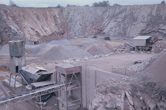
Fairy Cave Quarry lies on the east side of Fairy Lane, about two kilometres east of Oakhill, between Stoke St Michael and Oakhill in the limestone of the Mendip Hills. Quarrying began on the site in the early 1920s, but commercial working started only after planning permission was granted in 1947, under the Mendip Stone Company. In 1963 the quarry was bought by Hobbs (Quarries) Ltd, a much larger limestone firm, and output grew. It covered about 29 acres and was worked in two lifts of about 15 metres each, no more than 30 metres deep, with its offices and other buildings on the west side of the lane. Its manager until 1972, Ted Garlick, joined the Cerberus Caving Club soon after it was founded in 1956, and through him the club was given the use of a cottage on quarry property in 1958.
As the face was cut back into the hillside above St Dunstan's Well Rising, a Bristol Waterworks abstraction point, it broke into cave after cave: Balch, Conning Tower, Fernhill, Hillier's, Hillwithy, Shatter, W/L and Withyhill. Fairy Cave itself was the only one not found by quarrying. Some 4,575 metres of passage were entered, and about 840 metres were destroyed by the workings. Because of the caves and the risk to water supplies in what became a water conservation area, no further extensions to the planning permission were granted, and production ended at the start of 1977. The quarry has since been used for rock climbing.
Geology
Mendip limestone cut by the Withybrook Fault; the caves carry water now fed by the Withybrook Slocker swallet to the south.
Workings
An open quarry of about 29 acres worked in two lifts, with offices and plant buildings on the west side of Fairy Lane.
Closure
Production ended at the beginning of 1977; no further planning extensions were granted because of the caves and the water supply.
What remains
Disused since 1977; caves intercepted by the workings survive in the quarry.
Redevelopment
Unknown.
Nearby mines
- New Rock Colliery — 2.0 miles (3.2 km) N
- Gurney Slade Quarry — 2.4 miles (3.8 km) NW
- Doulting Quarry — 2.5 miles (4.0 km) S
- Vobster Breach Colliery — 2.6 miles (4.2 km) E
- Wellsways Colliery — 2.9 miles (4.6 km) N
Straight-line distance, within 9 miles (15 km). Show on the map.
Recorded claims
Individual factual claims, each attached to the source(s) that support it below. Where sources disagree, both are kept.
- Quarrying began on the site in the early 1920s. 1,2
- Hobbs (Quarries) Ltd acquired the quarry in 1963 and worked it on a much larger scale. 1,2
- Cutting back above St Dunstan's Well Rising, the quarry intercepted a series of caves. 1,2
- About 4,575 metres of cave passage were entered, and about 840 metres destroyed by quarrying. 2
- The quarry ceased production in 1977. 1,2
Photographs & further reading
The quarry's history and the caves it found, from the society's 1977 study.
View sourceThe quarry, its owners and a list of its caves.
View sourceSources
- (secondary) Fairy Cave Quarry — Wikipedia
- (secondary) Fairy Cave Quarry — Cerberus Spelaeological Society
Record created: 4 October 2026 · Last researched: 4 October 2026