 MineArchive
Fremington Edge Quarry
| Also known as | Fremington Chert Quarry, Fremington Edge Chert Quarry |
|---|---|
| Location | Fremington Edge, above Reeth, Swaledale, North Yorkshire — 54.4057, -1.9457 (exact) |
| Commodity | Chert |
| Type | Stone |
| Worked | By 1905–1950 |
| Maximum depth | Unknown. |
| Operators | Boulder Flint Co. Ltd. (1910–?) |
Overview
Fremington Edge Quarry worked chert from underground levels high on the escarpment north of Reeth, and was the best-remembered and last-surviving chert quarry in Swaledale and Arkengarthdale. Its stone did not build or roof anything: chert is a hard, near-pure silica, and it went to the Staffordshire potteries to be used as the grinding medium that reduced flint to the fine white powder china is made from. The Durham Mining Museum's run of statutory returns shows it working from at least 1905 to 1950, and its spoil heaps are still conspicuous on the Edge.
History
Fremington Edge is a three-mile wall of crags and scree north of Reeth, forming the south-eastern side of Arkengarthdale where that dale meets Swaledale. It stays above 1,300 feet for its whole length and reaches 1,552 feet at the northern end. The Edge is scattered with the remains of old lead and chert mines, with many disused shafts and spoil heaps, and it was formed after the last Ice Age when meltwater from the retreating glaciers caused a landslip that exposed the rocky outcrops.
Chert was quarried in the two dales from about 1904 until 1954, and this was the principal working. The market was the Staffordshire potteries, where in the eighteenth century Josiah Wedgwood, trying to emulate fine oriental porcelain, had found that flint ground between chert stones produced a superior white base for china manufacture. The chert went south by lorry.
The statutory returns give the shape of the working life. The mine appears with an output of chert in 1905, 1910, 1915, 1921, 1925, 1930, 1935, 1945 and 1950. Its workforce was 18 in 1905, ten of them below ground, rising to 23 in 1910 with 21 below — the deepest commitment to underground working in the run — then 16 in 1915, 21 in 1921, and falling away to 9 in 1925 and 8 in 1930. It recovered to 13 in 1935, dropped to 6 in 1945, and stood at 10 in 1950, evenly split above and below ground. The Boulder Flint Co. Ltd. is recorded as owner from the 1910s and still held it in 1914, when sixteen men worked underground and two on the surface.
Two men were killed at the quarry in the years the returns cover. Michael Hillery, a miner aged 30, died on 25 April 1907, killed by a fall of roof which came down at a clay back next the face and broke down the timber. Albert Harker, a miner aged 28, died on 2 August 1912, killed by a fall of side at the face. They were separate accidents five years apart, and neither is recorded here as a disaster: this archive's test is two or more deaths in a single incident.
Geology
Chert is a hard, dense form of silica — cryptocrystalline quartz — which occurs in the Carboniferous limestones of the northern Pennines as beds and nodular bands within the limestone sequence. It is that near-purity and hardness that made it valuable: chert is hard enough to grind flint without contaminating it, which is precisely what the pottery trade needed. The Edge exposes the Yoredale succession of alternating limestones, shales and sandstones, and carries the remains of lead workings as well as chert ones; the same ground that yielded lead ore in veins yielded chert in beds, and the two industries overlapped in place and sometimes in the workings themselves.
Geological setting: Sedimentary Beds and Seams (well documented example)
Workings
Underground. The larger commercial quarries of Swaledale and Arkengarthdale in the first half of the twentieth century often took their stone from underground mines rather than from open faces, sometimes reusing old lead workings, and this quarry was worked in underground levels high on Fremington Edge. The employment returns bear that out: in 1910, 21 of the 23 people on the books worked below ground. Large spoil heaps from those workings remain easily visible today, and a miners' track still runs up onto the Edge.
Closure
The chert trade in the two dales ran from about 1904 to 1954, and this quarry was its last survivor. It was still returning chert, and ten people, in 1950. No source gives a precise closure date or a reason, but the end of chert quarrying here belongs to the wider mid-century change in how the pottery industry prepared its raw materials rather than to anything that happened on the Edge.
What remains
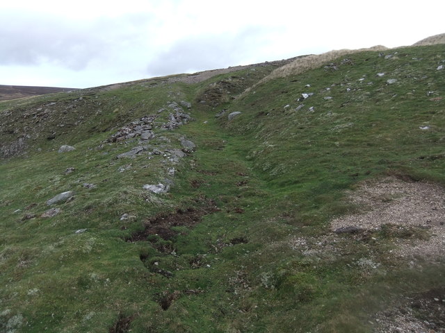
Disused, and legible. The spoil heaps from the underground workings remain easily visible high on Fremington Edge, and a miners' track photographed in October 2016 still climbs the escarpment. The Edge is open country in the Yorkshire Dales National Park, crossed for its full length by a footpath and a dry stone wall.
Large spoil heaps from the underground workings, conspicuous on the escarpment, and the miners' track running up to them. The Edge also carries the remains of the lead mines that worked the same ground, with many disused shafts and further spoil heaps.
Related mines
- Billy Bank Mine — The Boulder Flint Company worked both: chert from Fremington Edge, and copper at Billy Bank found while seeking chert.
Nearby mines
- Hurst Mines — 0.8 miles (1.2 km) NW
- Wetshaw Mine — 0.9 miles (1.4 km) W
- Booze Mine — 1.4 miles (2.3 km) W
- Slei Gill Mine — 1.8 miles (2.8 km) W
- Sir Francis Level (Lownathwaite Mine) — 1.8 miles (2.9 km) W
Straight-line distance, within 9 miles (15 km). Show on the map.
Recorded claims
Individual factual claims, each attached to the source(s) that support it below. Where sources disagree, both are kept.
- The Durham Mining Museum's records show an output of chert from Fremington Edge in 1905, 1910, 1915, 1921, 1925, 1930, 1935, 1945 and 1950. 1
- Employment at the quarry was 18 in 1905 (10 below ground, 8 surface), 23 in 1910 (21 below, 2 surface), 16 in 1915, 21 in 1921, 9 in 1925, 8 in 1930, 13 in 1935, 6 in 1945 and 10 in 1950. 1
- The 1914 List of Mines records Fremington Edge Quarry at Reeth, working chert, owned by the Boulder Flint Co. of Reeth, Richmond, with 16 employed underground and 2 at surface. 2
- Michael Hillery, a miner aged 30, was killed at the quarry on 25 April 1907 by a fall of roof which came down at a clay back next the face and broke down the timber. 1
- Albert Harker, a miner aged 28, was killed at the quarry on 2 August 1912 by a fall of side at the face. 1
- Chert was quarried in Swaledale and Arkengarthdale from about 1904 until 1954 and sold primarily to the Staffordshire potteries, where Josiah Wedgwood had discovered in the 18th century that flint ground between chert stones produced a superior white base for china manufacture. 3
- Fremington Edge was the best-remembered and last-surviving chert quarry in the two dales, operated in underground workings high on the Edge, and large spoil heaps from those workings remain easily visible today. 3
- Fremington Edge is a 3-mile wall of crags and scree north of Reeth, staying above 1,300 feet for its full length and reaching 1,552 feet at its northern end; it is scattered with the remains of old lead and chert mines, and the chert was taken by lorry to Staffordshire. 4
Photographs & further reading
The Durham Mining Museum's operational record: output and employment across nine statutory returns from 1905 to 1950, and the names and circumstances of the two men killed here.
View sourceThe archaeology group's account of how chert and flagstone were got in these dales, largely underground and often through abandoned lead workings, and why the Staffordshire potteries wanted the stone.
View sourceSources
- (primary) Fremington Edge (Chert) — Durham Mining Museum
- (primary) 1914 List of Mines under the Metalliferous Mines Act: York, North Riding — Durham Mining Museum
- (secondary) Chert and Flagstone Quarries — Swaledale and Arkengarthdale Archaeology Group (SWAAG)
- (secondary) Fremington Edge — Wikipedia
Record created: 5 September 2026 · Last researched: 5 September 2026