 MineArchive
Hurst Mines
| Location | Hurst Mining Field, between Fremington Edge and Marrick, Swaledale, North Yorkshire — 54.4158, -1.9539 (approximate) |
|---|---|
| Commodities | Lead, Barite, Fluorspar |
| Type | Metal |
| Worked | By late 16th century–1890 (brief 1938 rework at Prys Mine) |
| Maximum depth | varied by shaft; Prys Level worked four sub-levels to 45 fathoms |
| Operators | London Lead Company (1747–1778) |
Overview
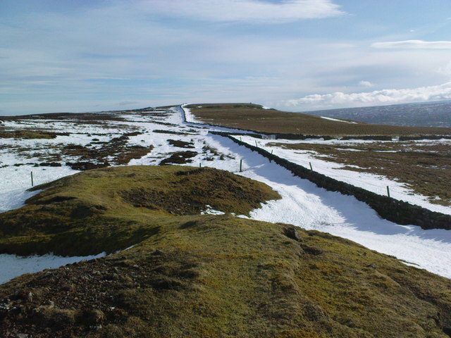
The Hurst Mining Field is a nine-square-mile lead-mining district on the plateau between Fremington Edge and the Clints valley, Swaledale, worked from at least the late 16th century until final abandonment in 1890. One of the most heavily capitalised setts in the dale — a 1718 lease specified 147 employed men — it comprised the core Hurst Mines complex together with the associated Prys, Copperthwaite and Jingle Pot workings, and left the starkest surface remains in Swaledale: two surviving engine-house chimneys and a landscape of shafts and spoil likened to a First World War battlefield.
History
Two 1592 survey plans show a large spread of shafts already worked on the Copperthwaite, Jingle Pot and Hurst veins, together with a mill at Marrick, indicating the field was substantially known and worked by the late 16th century, when the mines belonged to the Marquis of Winchester (later Duke of Bolton). Around 1679 the Duke leased part of Copperthwaite, Jingle Pot and Hind Rake to Humphrey Wharton and Philip Swale, with ore required to be sold and dressed within the Manor of Marrick. In 1718 the Duke let the mines to a substantial capital venture — Samuel Mellor and Thomas Jones of Flintshire with John Halsall and William Thomson of London — whose lease specified 147 men employed across fifteen working shafts and drainage into a 500-fathom Old Water Level.
On 11 June 1747 the London Lead Company took over the lease of the mines and the Manor of Marrick for 31 years, rebuilding the Marrick smelt mill. In 1849 J. Spence and Sons sank the 225ft Underset Shaft at Copperthwaite, and from 1852 a continuous, well-documented run of production figures survives under a succession of operators — the Hurst Company, Hurst Mining Company, Yorkshire Lead Mines Company Ltd, and finally Hurst Lead Mines Ltd. In 1862 Robert Daykin, agent at Hurst and Prys, gave evidence to the Kinnaird Commission on the employment of children and young persons, describing serious ventilation problems at Prys Level dependent on a natural swallow-hole air circuit.
A Craven Herald announcement of 22 July 1882 recorded the sale of Hurst's mining plant and machinery to a Sunderland iron merchant, 'sounding the death knell' for the mine; ore was reportedly then ripped from support pillars with no regard for future workings, briefly boosting output before falling lead prices and a lawsuit brought final abandonment in 1890. Morale was reportedly so poor by the end that some 200 tons of dressed ore was left in tubs underground. A small, poorly financed attempt to rework Prys Mine was made in 1938 by the North Riding Lead Mining Company, using bucket drainage and hand drilling, but was soon abandoned.
Geology
Lead, with baryte and fluorspar in the same ground, on the Copperthwaite, Jingle Pot, Hurst and Hind Rake veins above Marrick in Swaledale.
Workings
The field's beds lie in a monocline, with the main ore-bearing Main Lime and Chert overlain by Red Beds/Crow Lime and Chert and underlain by the Underset Lime and Chert; gangue minerals were chiefly pink barytes and calcite, with minor fluorspar and occasional white witherite. Major veins included the Racca (Grinton Dam) Vein, the field's dominant lode, together with the Wellington, Woodgarth, Cleminson, Blindham-Redshaft, Trench, Copperthwaite, Copperthwaite North and Jingle Pot veins. Principal workings included Queens Level, the main drive at 1097ft above sea level with the field's main dressing floors at its mouth; Cat Shaft, 40 fathoms deep with its own chimney and steam engine; Hurst Horse Level, the highest major level at 1277ft; and Wellington Whim Shaft on Fremington Edge, marking the field's western boundary. The separate Prys Mine group, worked via the March, Dolphin, Richardsons, Suntors and Prys shafts, installed a hydraulic pumping engine around 1870, fed by a reservoir and watercourse from Cogdale Beck, draining four sub-levels down to 45 fathoms through a natural swallow-hole.
Closure
A small, poorly financed attempt to rework Prys Mine was made in 1938 using bucket drainage and hand working.
What remains
Two engine-house chimneys survive prominently opposite the site of Hurst Hall, one square (on Cat Shaft, with a dressed-stone engine bed) and one round, both said to have withstood army attempts to demolish them with cannon fire during the Second World War. The Grinding Mill Dam survives west of Hurst Hall with traces of gin circles on several shafts. Prys Level has the best-preserved features in the field — an intact 'shop' building, two bridges over the beck, a well-preserved set of bouse teams and a waterwheel pit — while Queens Level's dressing floors have largely disappeared, leaving only mounting bolts and part of a waterwheel pit. As of a 1978 survey only Prys and Queens Levels remained open underground, with Queens found extremely unstable and unsafe to enter. The wider spoil-heap landscape between Fremington Edge and Hurst village has been likened to a First World War battlefield.
Nearby mines
- Wetshaw Mine — 0.7 miles (1.1 km) SW
- Fremington Edge Quarry — 0.8 miles (1.2 km) SE
- Booze Mine — 1.3 miles (2.0 km) SW
- Slei Gill Mine — 1.4 miles (2.2 km) W
- Arkendale Mine — 1.6 miles (2.6 km) W
Straight-line distance, within 9 miles (15 km). Show on the map.
Recorded claims
Individual factual claims, each attached to the source(s) that support it below. Where sources disagree, both are kept.
- The Duke of Bolton's 1718 lease of the mines specified 147 men employed across fifteen working shafts, 13-22 fathoms deep, draining into a 500-fathom Old Water Level. 1
- The London Lead Company took over the lease of the mines and the Manor of Marrick on 11 June 1747 for 31 years, rebuilding the Marrick smelt mill. 1
- Robert Daykin, agent at Hurst and Prys, gave evidence to the Kinnaird Commission on the employment of children and young persons in mines, describing serious ventilation problems at Prys Level dependent on a natural swallow-hole air circuit. 1
- Yorkshire Mineral Statistics record ore output peaking at 1,171 tons of ore (749.5 tons of lead) in 1867, with other strong years in 1886 and 1888 under Hurst Lead Mines Ltd. 1
- Falling lead prices and a lawsuit brought final abandonment in 1890; workforce had already fallen from 92 in 1877 to just 26 by 1880. 1
- The BGS mine plans catalogue holds records for Hurst Mines and Hurst Lead Mines, including plans and sections for Pryes (Prys) Level and Queen Level, held publicly. 2
Sources
- (secondary) The Hurst Mining Field, Yorkshire (British Mining No. 23, 1983, pp. 61-77) — L. O. Tyson, Northern Mine Research Society
- (primary) Hurst mine plan records — British Geological Survey mine plans catalogue
Record created: 26 August 2026 · Last researched: 26 August 2026