 MineArchive
Ashington Colliery
| Location | Ashington, 15 miles north of Newcastle upon Tyne, Northumberland — 55.1839, -1.5961 (approximate) |
|---|---|
| Commodities | Coal, Fireclay |
| Type | Coal |
| Worked | 1867 (Bothal Pit sunk)–March 1988 |
| Maximum depth | 180 yards (Carl and Duke pits) |
| Operators | Harrison, Carr and Company, Henderson and Company, Ashington Coal Company (1880–1947), National Coal Board (1947–1986), British Coal Corporation (1986–1988) |
Overview
Ashington Colliery worked the coal under the Northumberland town that grew up around it, from the sinking of the Bothal Pit in 1867 to closure in 1988. Six shafts and two drifts, all of them shallow, took a dozen named seams in turn, and at its peak in 1921 the pit employed 5,455 people, 4,076 of them below ground. The rows of company housing that spread east of the railway made Ashington what was long called the world's largest mining village. The site is now a business park, its spoil heaps grown over into woodland.
History
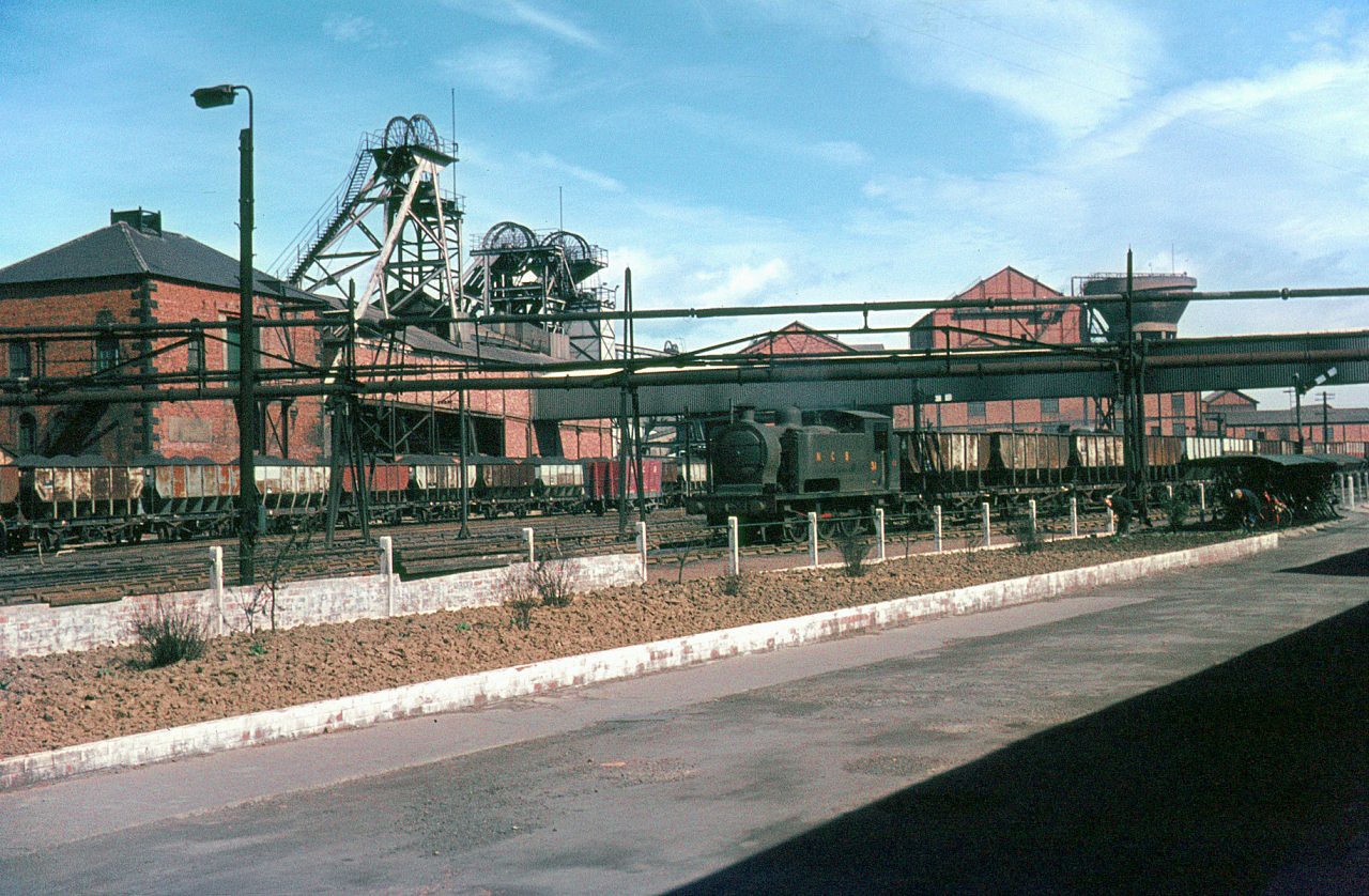
Coal had been drawn here long before the colliery took its modern shape: bell-shaped pits and monastic workings were found under Ashington during tunnelling in the twentieth century. The Bothal Pit was sunk in November 1867, reaching the Main seam at only 72 yards, and the Carl Pit followed on 24 March 1873 and the Duke Pit in 1885, both put down to the Low Main at 180 yards. Harrison, Carr and Company held the mine in the 1850s and Henderson and Company in the 1860s, but the colliery belongs to the Ashington Coal Company, which had it from the 1880s until nationalisation. By 1900 the company also owned Linton and Woodhorn, employing 4,354 people across the three under one manager, E. O. Southern; Robert L. Booth had managed Ashington through the 1880s and 1890s and Joseph J. Hall held it by 1902. Employment climbed from 2,848 in 1894 to 5,455 in 1921, and in the 1930s the Ashington pits were raising about half of the three million tons of household and steam coal that the group sold each year. The Bothal Barns Drift was opened in the 1920s and the Coneygarth Drift in 1924. The Plessey seam was abandoned on 9 September 1937 and the Yard seam in 1944; in 1947, the year the colliery passed to the National Coal Board, it raised 948,000 tons. By the 1970s it was down to the Three Quarter and Tilley seams with a quarter of its old workforce, and 350 people were left in 1988. The Duke of Portland had built the first housing here in the 1840s to draw in people escaping the Great Famine in Ireland; the company then laid out the Hirst grid, its north-south streets named after British trees and its east-west streets numbered as avenues, and some of the incomers arrived from Cornwall with tin-mining skills.
Geology
The colliery worked the Coal Measures of the Northumberland coalfield, a thick alternation of sandstones, mudstones and coals that the sinkers recorded as post and metal. The Bothal Pit's log runs from soil and clay through white post and soft blue metal, a whin stone band carrying water at about 19 metres, black metal with cockle shells and thin coals, to the supposed High Main seam at 43 metres and the supposed Grey seam at 65 metres. The seams are shallow and close together, which is why the colliery was worked by a number of small shafts to different beds rather than two deep ones. Named seams worked over its life include the High Main, Main, Yard, Low Main, Five Quarter, Bensham, Plessey, Diamond, Bentinck, Bottom Main, Middle Main, Three Quarter, Tilley and Victoria. In the Five Quarter district off the Duke Pit the seam ran 3 feet 8 inches thick including two dirt bands, with moderately hard shale above and below, about 500 feet of cover and a gradient of one in eighteen, and the ground was broken by goaf-breaks from earlier working in the Low Main ten fathoms beneath.
Geological setting: Sedimentary Beds and Seams (well documented example)
Workings
Six shafts, three of them drawing coal and three for ventilation and other duties, all 13 feet in diameter: the Bothal Pit of 1867 at 72 yards to the Main seam, the Carl and Duke pits at 180 yards to the Low Main, and the New Moor and Portland pits. The Carl upcast was specially fitted for raising and lowering men. Two drifts were added, Bothal Barns in the 1920s and Coneygarth in 1924. The workforce was overwhelmingly underground, 4,076 of 5,455 in 1921. Coal cutting was heavily mechanised between the wars, served by compressed air from a Brown Boveri turbo compressor driven by a 1,020 horsepower Metropolitan-Vickers turbine, with a second reciprocating compressor by Walker; the winders and haulage engines exhausted into Rateau accumulators feeding a 1,500 kilowatt mixed-pressure turbine. Two sets of screens graded the coal, the large Yard seam coal loaded separately as a household grade, the rest cleaned on spiral separators and a pneumatic plant. Fireclay was raised alongside the coal from 1894 into the 1970s.
Closure
The Durham Mining Museum gives closure in March 1988, with the colliery still returning household and steam coal and 350 people employed in that year. The Northern Mine Research Society's list of Northumberland collieries gives October 1986, the date the Bothal shaft itself was closed. The buildings were cleared and the pit yard redeveloped.
What remains
Nothing of the colliery stands. The pit yard on the north-west side of Ashington is now the Wansbeck business park, and the ground north of it, where the spoil heaps stood, has been planted as woodland with laid-out paths and interpretation boards showing the site as a working colliery. Part of the site is in use as sports pitches.
No colliery building survives. The shaped ground of the old bings under the woodland, and the line of the Ashington Collieries railway, are what is left to see.
Redevelopment
The pit yard became the Wansbeck business park under a regeneration scheme and houses light industry; the spoil ground beside it is public woodland with a pond at its centre.
Related mines
- Ellington Colliery — Both belonged to the Ashington Coal Company, whose Ashington, Linton, Woodhorn and Ellington pits together sold about three million tons of coal a year between the wars.
- Lynemouth Colliery — Both were Ashington Coal Company pits; the company built a new colliery township at Lynemouth, and the Ashington railway later carried coal to the power station there.
- Woodhorn Colliery — Both were Ashington Coal Company collieries at Ashington, worked together from the 1890s to nationalisation and linked by the company's own railway; Woodhorn Museum now stands on the Woodhorn site.
Nearby mines
- Woodhorn Colliery — 2.0 km E
- Pegswood Colliery — 3.6 km W
- Lynemouth Colliery — 4.1 km NE
- Choppington 'A' Pit — 4.3 km S
- Choppington 'B' Pit — 4.5 km S
Straight-line distance, within 15 km. Show on the map.
What's uncertain
Points where sources disagree or the record could not be settled; both accounts are kept. All open questions in the archive.
- The first shaft was sunk in 1866. (disputed) 3
- The colliery closed in March 1988. (disputed) 1
- The colliery closed in October 1986. (disputed) 5
Recorded claims
Individual factual claims, each attached to the source(s) that support it below. Where sources disagree, both are kept.
- The Bothal Pit was sunk in November 1867 to the Main seam at 72 yards. 1,2
- The first shaft was sunk in 1866. (disputed) 3
- Six shafts were worked, three drawing coal and three for ventilation and other duties, each 13 feet in diameter. 3
- The Carl and Duke pits reached the Low Main seam at 180 yards. 3
- Employment peaked at 5,455 in 1921, of whom 4,076 worked below ground. 1
- The colliery raised 948,000 tons of household and steam coal in 1947. 1
- The Plessey seam was abandoned on 9 September 1937 and the Yard seam in 1944. 1
- Held by the Ashington Coal Company from the 1880s until nationalisation in 1947. 1,4
- The colliery closed in March 1988. (disputed) 1
- The colliery closed in October 1986. (disputed) 5
- The colliery site is occupied by a business park, with the former spoil ground planted as woodland. 6,7
Photographs & further reading
Owners, shafts, output, employment year by year, seams worked and a long list of those killed at the colliery.
View sourceA trade-press description of the colliery at its most mechanised, with shaft depths, seam sections and the surface plant.
View sourceSources
- (primary) Ashington Colliery — Durham Mining Museum
- (primary) Ashington Colliery, Bothal Pit: shaft details and strata sunk through, 1867 — Durham Mining Museum
- (primary) Ashington Colliery (Colliery Engineering) — Durham Mining Museum
- (primary) Ashington Coal Co., Ltd. — Durham Mining Museum
- (secondary) Ashington Area: collieries after nationalisation — Northern Mine Research Society
- (secondary) Ashington — Wikipedia
- (observational) Site of Ashington Colliery (photograph, 2023) — Geograph Britain and Ireland
Record created: 24 September 2026 · Last researched: 24 September 2026