 MineArchive
Wheal Basset (Basset Mines)
| Location | Carnkie, Carn Brea, Cornwall — 50.2100, -5.2850 (approximate) |
|---|---|
| Commodities | Tin, Copper |
| Type | Metal |
| Worked | From 1815–1918 |
| Operators | Basset Mines Ltd (1896–1918) |
Overview
Basset Mines, on the north-west slopes of Carn Brea between Camborne and Redruth, brought together three older setts — South Wheal Frances, West Wheal Basset and Wheal Basset itself — into one of the last major Cornish mining companies still operating in the early 20th century, before the collapsing price of tin finally closed it in 1918.
History
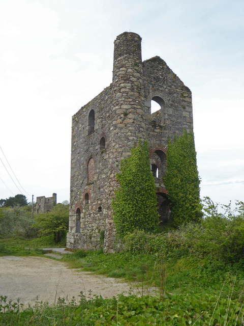
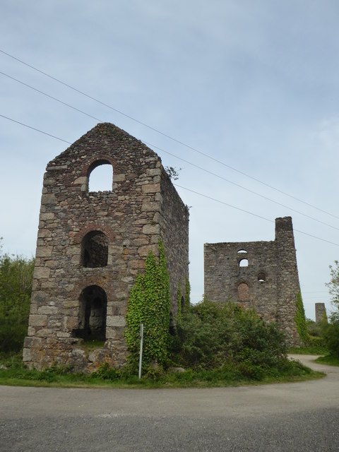
Copper had been worked at Wheal Basset and its neighbouring setts since at least 1815, part of the dense cluster of mines that made the Camborne-Redruth district one of the richest copper-producing areas in the world through the 18th and early 19th centuries. As the shallower copper lodes were worked out through the 1820s and 1830s, deeper workings struck the rich tin-bearing Great Flat Lode running beneath the district, and the mines switched increasingly to tin. In 1896 three neighbouring setts — South Wheal Frances, West Wheal Basset and Wheal Basset — were formally amalgamated into a single company, Basset Mines Limited, headquartered in Redruth. At Lyle's Shaft, a new 80-inch Cornish engine — built by Harvey & Co in 1879-80 to pump water from the workings — was housed in a purpose-built engine house, stone for which was quarried by demolishing four earlier, now-redundant engine houses on the sett. A matching whim engine house for winding was added alongside it in 1880. The company continued working through the early 20th century, but the collapse in tin prices during and after the First World War finally forced Basset Mines to close in 1918.
Geology
The mine worked tin- and copper-bearing lodes within the Camborne-Redruth orefield, including the rich, gently dipping Great Flat Lode struck at depth beneath the district's older, steeper copper lodes — part of the same hydrothermal, granite-related Cornubian mineralisation worked across west Cornwall.
Geological setting: Hydrothermal Deposits (well documented example), Veins and Lodes (well documented example)
Workings
Lyle's Shaft was equipped from 1879-80 with an 80-inch Cornish engine for pumping and, from 1880, a matching whim engine house for winding; the West Basset Stamps, built by the Tuckingmill Foundry in 1875, stand above one of the finest surviving 19th-century tin dressing floors anywhere in the world.
Closure
Falling tin prices during and after the First World War forced Basset Mines to close in 1918, ending large-scale mining across the combined sett.
What remains
The Lyle's Shaft pumping and whim engine houses survive at Carnkie, along with the West Basset Stamps engine house and its associated 19th-century tin dressing floor — among the most complete surviving mine-processing landscapes in Cornwall.
Related mines
- South Wheal Frances — Amalgamated with Wheal Basset into Basset Mines Ltd in 1896.
Nearby mines
- Carn Camborne Mine — 0.2 miles (0.3 km) SW
- Cook's Kitchen Mine — 0.5 miles (0.9 km) NE
- Dolcoath Mine — 0.5 miles (0.9 km) N
- Tincroft Mine — 0.7 miles (1.1 km) NE
- Carn Brea Mine — 0.9 miles (1.4 km) NE
Straight-line distance, within 9 miles (15 km). Show on the map.
Recorded claims
Individual factual claims, each attached to the source(s) that support it below. Where sources disagree, both are kept.
- In its early working alone, the mine extracted 14,178 tons of black tin and 94,200 tons of 8.5% copper ore; the combined Basset Mines company worked from 1896 until falling tin prices closed it in 1918. 1
- Lyle's Shaft's 80-inch Cornish pumping engine, built by Harvey & Co and housed from 1879-80, used stone quarried by demolishing four earlier engine houses on the same sett. 1,2
- Basset Mines of Redruth was registered on 9 January 1896 to take over the tin mines worked on the cost-book principle at Illogan, previously owned by the Wheal Basset Mines and the South Frances United Mines. 3
- Between 1815 and 1900 Wheal Basset produced 94,200 tons of 2.5% copper ore and 13,178 tons of black tin. Basset Mines, whose chairman Francis Oats died in September 1918, shut down in December 1918 after the slump in the price of tin that followed the First World War. 1
Photographs & further reading
An April 2010 walk over the surface remains: the pumping house and its grated Lyes shaft, the vanner house, stamps and dressing floor, the winding house, and the line of the tramway that carried ore from the (now caved) adit down to the dressing floor and on to South Wheal Frances. Notes the consolidation work that has stabilised the buildings and sealed the underground entrances.
View sourceA March 2022 tour of several Basset family sites around Carn Brea in one visit, beginning at South Wheal Frances, with the history of the company's amalgamation into Basset Mines in 1895 and the discovery of the Great Flat Lode in 1872. Useful for seeing how the separate setts of the group relate to one another on the ground.
View sourceSources
- (secondary) Basset Mines — Wikipedia
- (primary) Stamps Engine House to West Basset Stamps on North Wheal Basset Sett — Historic England (Listed Building record)
- (secondary) Basset Mines (Graces Guide, from the Stock Exchange Year Book 1908) — Grace's Guide to British Industrial History
- (primary) Basset North and West Carn Brea mine plans (BGS Mine Plans Catalogue) — British Geological Survey / The Coal Authority
Record created: 23 August 2026 · Last researched: 24 September 2026