 MineArchive
Weetslade Colliery
| Also known as | Lizzie Pit, Burradon (Lizzie) Pit |
|---|---|
| Location | Weetslade, between Wideopen and Dudley, North Tyneside (historically Northumberland), Tyne and Wear — 55.0436, -1.5961 (approximate) |
| Commodity | Coal |
| Type | Coal |
| Worked | 1903–10 September 1966 |
| Maximum depth | 1,140 feet (347 m) to the Beaumont Seam; coal wound from the Bensham inset at 800 feet |
| Operators | Burradon and Coxlodge Coal Company (1903–?), Hazlerigg and Burradon Coal Co. Ltd (?–1946), National Coal Board (1947–1966) |
Overview
A Northumberland-coalfield colliery at Weetslade, between Wideopen and Dudley about seven miles north of Newcastle upon Tyne, sunk from August 1900 and opened in 1903 by the Burradon and Coxlodge Coal Company. Its workings adjoined and were connected underground with Burradon Colliery, though the two pits were ventilated and managed separately. Weetslade worked the Bensham and Low Main seams for most of its life, was fully mechanised from 1944 with arcwall cutters, Joy loaders and battery-powered shuttle cars, and on 1 October 1951 an explosion of firedamp in the Bensham Seam killed five men and set off one of the longest recovery operations in British mining (see Disasters, below). The pit closed on 10 September 1966; its surface plant went on washing Burradon coal until 1980, and the great spoil heap is now Weetslade Country Park.
History
Sinking of the Lizzie Pit began on 6 August 1900, and the account of strata kept for the North of England Institute of Mining and Mechanical Engineers records the shaft passing the High Main at 538 feet, the Yard at 739 feet, the Bensham at 790 feet and the Low Main at 879 feet before reaching the Beaumont Seam at 1,139 feet. The colliery opened in 1903 under the Burradon and Coxlodge Coal Company, whose Burradon Colliery lay immediately to the east; the two sets of workings were connected underground and the 1920 Ordnance Survey sheet labels the new pit 'Burradon (Lizzie) Pit'. Coal left by a branch of the Seaton Burn Wagonway. In its early decades Weetslade worked the Five Quarter, High Main and Yard seams, all of which had been given up by the 1940s, when the Bensham and Low Main carried the output. By the 1940s the owner was the Hazlerigg and Burradon Coal Co. Ltd, which ran Hazlerigg, Burradon and Weetslade together; the 1940 return gives a combined Burradon and Weetslade workforce of 1,170. In 1944 the Bensham Seam was judged suitable for complete mechanisation on the American pattern: caterpillar-mounted Universal arcwall cutting machines, Joy loaders, battery shuttle cars and a trunk belt conveyor, all electrically driven, working a bord and pillar layout with places arcwalled 14 feet wide between pillars 86 feet square. Nationalisation in 1947 put the pit into 'C' Group of No. 1 Area of the Northern Division, employing 521 people that year on an output of 160,000 tons of household, manufacturing and steam coal. By September 1951 the pit was raising about 700 tons a day, 450 from the Low Main and 250 from the Bensham, with 408 men underground and 183 on the surface. The 3rd East District of the Bensham had been troubled since 1950 by water breaking through fault planes from flooded Yard Seam workings 50 feet above, and on 1 October 1951 an explosion of firedamp there killed the deputy Thomas Whitney and four workmen; the recovery of the district, complicated by flooding and by hydrogen given off by submerged shuttle-car batteries, was not finished until April 1953 (see Disasters, below). The Bensham was still being worked in 1965 alongside the Low Main and the deeper Beaumont, and employment actually rose in the pit's last years, from 638 in 1960 to 1,066 in 1965, 917 of them underground. Weetslade closed on 10 September 1966. The washery kept running on coal from Burradon until that pit closed in 1975, and the surface site was finally abandoned in 1980. The Tyne and Wear Historic Environment Record dates the end of mining at the site to 1960, but the Durham Mining Museum and Co-Curate both give 1966, and the seam returns for 1964 and 1965 show coal still being worked.
Geology
Weetslade worked the Middle Coal Measures of the Northumberland coalfield, a Carboniferous sequence of sandstones ('post' in the local sinking vocabulary), mudstones ('grey metal'), fireclays ('seggar') and coal seams laid down as sedimentary beds. The Lizzie Pit sinking record shows the seams in descending order: the High Main, 4 feet 6 inches thick at 538 feet; a thin Grey seam; the Yard, 3 feet at 739 feet; the Bensham, a 7-foot section including partings at 790 feet; the Low Main, 3 feet at 879 feet; and the Beaumont, 2 feet 8 inches at 1,139 feet. The Bensham as worked was 3 feet of top coal and 2 feet of bottom coal separated by a stone band varying from 5 inches to 3 feet 6 inches, dipping at 1 in 22 to the south-east under a blue shale roof and over a thick seggar floor, and yielded a good house and steam coal with 36 per cent volatile matter. Large faults cut the Bensham workings south of the shaft and forced changes to the ventilation layout as development crossed them; fault planes also carried water down from the abandoned, flooded Yard Seam workings into the 3rd East District, the flooding that preceded the 1951 explosion.
Geological setting: Faults and Fractures (well documented example), Sedimentary Beds and Seams (well documented example)
Workings
One shaft and one surface drift, 200 yards apart. The Lizzie Pit shaft, the downcast, was 12 feet in diameter and sunk to the Beaumont Seam at 1,140 feet, with coal wound from an inset at the Bensham Seam at 800 feet. The drift was the upcast, with an Aeroto surface fan passing 67,750 cubic feet of air a minute at a water gauge of 44 inches; a 61,800 cubic feet per minute booster fan stood in the main return 700 yards from the shaft to serve the Bensham development. The Bensham Seam was worked bord and pillar, mechanised from 1944: arcwall machines cut out the stone band, Joy loaders filled it into shuttle cars for stowing in old stentons, and the blasted coal went the same way to a belt conveyor running to a loading station known as the Hopper, about 1,700 yards from the shaft, where an endless-rope haulage took over. A group of about six working places under one deputy was known locally as a 'flat'. Each shuttle car carried two one-ton lead-acid batteries, changed at the end of every shift at an underground charging station. The Weetslade workings connected underground with Burradon Colliery, but the two mines kept separate ventilation systems and separate management.
Closure
Closed by the National Coal Board on 10 September 1966. Nothing is recorded of the reason; the pit was still raising coal from three seams and employing over a thousand people in 1965. The surface plant continued as a washery for Burradon coal until 1980, after which the site lay derelict until it was landscaped as Weetslade Country Park, opened in 2006.
What remains
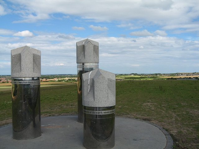
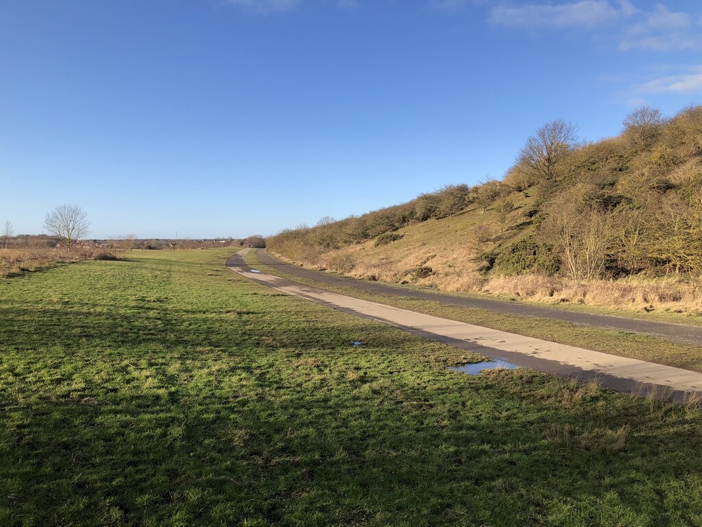
The colliery site and its three spoil heaps, the largest up to 25 metres high and visible from Newcastle city centre, have been landscaped into Weetslade Country Park, 43 hectares managed by Northumberland Wildlife Trust for the Land Trust and opened on 17 June 2006. A sculpture of three drill heads stands on the summit at about 95 metres above sea level; the old wagonway through the park carries the Reivers coast-to-coast cycle route. Geograph photographs from 2007 and 2022 show grassed slopes, reed beds and ponds with no colliery buildings in view. The pithead baths were recorded as an extant building by the Historic Environment Record in 2000, as one of only three surviving locally, and an early-nineteenth-century metal bridge over the Seaton Burn Wagonway cutting also survives.
Landscaped spoil heaps forming Weetslade Country Park, with the drill-head sculpture on the summit; the pithead baths building was extant in 2000 and a small early-nineteenth-century metal bridge spans the wagonway cutting.
Redevelopment
Weetslade Country Park (opened 17 June 2006), a Northumberland Wildlife Trust reserve on the former colliery and spoil heap.
Related mines
- Burradon Colliery — Weetslade's workings were connected underground with Burradon's, though separately ventilated and managed; both pits shared the same owners, and after Weetslade closed in 1966 its washery treated Burradon coal until 1980.
- Hazlerigg Colliery — Both were run by the Hazlerigg and Burradon Coal Co. Ltd before nationalisation, and before that by the Burradon and Coxlodge Coal Company.
Nearby mines
- Burradon Colliery — 0.8 miles (1.2 km) NE, Northumberland
- Wideopen Colliery — 0.9 miles (1.4 km) W
- Dudley Colliery — 1.0 miles (1.6 km) N
- West Moor Colliery — 1.3 miles (2.2 km) SE
- Seaton Burn Colliery — 1.8 miles (2.8 km) NW
Straight-line distance, within 9 miles (15 km). Show on the map.
Disasters & major incidents
-
Weetslade Colliery Explosion
1 October 1951 · Explosion · 5 fatalities
At 6.45 a.m. on Monday 1 October 1951 an explosion of firedamp swept the 3rd East District of the Bensham Seam at Weetslade Colliery, killing the deputy Thomas Whitney and the four men of his pumping and repair shift. The district had been gassed out for five days after flooding from old workings above wrecked its return airway and the manager short-circuited the ventilation to keep a pump running. Recovering the bodies took until November 1952 and the investigation until April 1953, held up first by rising water and then by the discovery of an explosive hydrogen-methane mixture given off by broken shuttle-car batteries, which forced the district to be deliberately flooded. The inquiry could not fix a definite cause, but found the only possible source of ignition to be an arc on the battery of a shuttle car the men had been using to move a fan.
What's uncertain
Points where sources disagree or the record could not be settled; both accounts are kept. All open questions in the archive.
- The Tyne and Wear HER entry states that mining ceased in 1960, with washing and sorting of Burradon coal continuing to 1980; the DMM, Co-Curate and the 1964 and 1965 seam returns all indicate coal was worked until 1966. (disputed) 4,2
Recorded claims
Individual factual claims, each attached to the source(s) that support it below. Where sources disagree, both are kept.
- Sinking of the Lizzie Pit shaft began on 6 August 1900. 1,2,3
- The colliery opened in 1903. 4,5,3
- Weetslade Colliery closed on 10 September 1966. 4,3
- The Tyne and Wear HER entry states that mining ceased in 1960, with washing and sorting of Burradon coal continuing to 1980; the DMM, Co-Curate and the 1964 and 1965 seam returns all indicate coal was worked until 1966. (disputed) 4,2
- The downcast shaft was 12 feet in diameter and sunk to the Beaumont Seam at 1,140 feet, with coal wound from the Bensham inset at 800 feet; the sinking record gives the Beaumont at 1,139 feet. 1,5
- The sinking record gives the High Main at 538 ft 9 in, the Yard at 739 ft, the Bensham at 790 ft 6 in, the Low Main at 879 ft 6 in and the Beaumont at 1,139 ft. 1
- Owned by the Burradon and Coxlodge Coal Co. Ltd in the 1910s, the Hazlerigg and Burradon Coal Co. in the 1940s, and the National Coal Board from 1947. 4,3,6
- Weetslade's workings adjoined and were connected with those of Burradon Colliery, but the two mines had separate ventilation systems and separate management. 5,3
- In 1944 the Bensham Seam was fully mechanised with caterpillar-mounted Universal arcwall cutters, Joy loaders, battery shuttle cars and a trunk belt conveyor, working bord and pillar with places 14 feet wide and pillars 86 feet square. 5
- In 1947 the colliery produced 160,000 tons of household, manufacturing and steam coal and employed 521 people, 350 of them below ground. 4,7,3
- In September 1951 the pit was producing about 700 tons a day, 450 from the Low Main and 250 from the Bensham, with 408 people underground and 183 on the surface. 5
- Employment rose to 1,066 in 1965, 917 of them underground, the highest figure in the NCB series for the pit. 4,7
- The surface drift was the upcast, with an Aeroto fan passing 67,750 cubic feet a minute at 44 inches water gauge, supplemented by a 61,800 cubic feet per minute booster fan in the main return 700 yards from the shaft. 5
- After closure the site continued in use as a washery until 1980. 2,3,8
- The colliery was served by a branch of the Seaton Burn Wagonway. 2,3
- The 1920 Ordnance Survey third edition shows the pit as 'Burradon (Lizzie) Pit'. 2
- Three spoil heaps survive; the main one rises up to 25 metres and is visible from Newcastle city centre. 9
- The pithead baths are recorded by the Tyne and Wear HER as one of only three surviving examples locally, possibly the only 1930-60 structures of the type left in Tyne and Wear and Northumberland. 10
- Weetslade Country Park, 43 hectares managed by Northumberland Wildlife Trust for the Land Trust, opened on 17 June 2006 with a drill-head sculpture on the summit. 3,11,8
- The BGS mine-plans catalogue holds a Mining Remediation Authority abandonment plan titled 'Weetslade' (catalogue NC581, Beaumont Or Harvey "N", dated 1966). 12
Photographs & further reading
Owners, output, employment, seams, shaft record, fatalities list and the full text of the 1951 inquiry report.
View sourceH.M. Divisional Inspector W. Brown's 1955 report, transcribed in full: the colliery, the 3rd East District, the explosion, the recovery and the cause.
View sourceThe Historic Environment Record's map-based account of how the colliery surface grew and changed from 1900 to 1980, with archive references.
View sourceThe reserve now occupying the colliery site and spoil heap: access, habitats and wildlife.
View sourceNewcastle University's summary of the colliery's dates, owners and afterlife, with linked photographs and records.
View sourceSources
- (primary) Account of the strata sunk through in the Lizzie Pit, Weetslade Colliery (An Account of the Strata of Northumberland and Durham as proved by Borings and Sinkings, Supplement, 1910) — North of England Institute of Mining and Mechanical Engineers, transcribed by the Durham Mining Museum
- (primary) Tyne and Wear HER 5445: Weetslade Colliery — Tyne and Wear Historic Environment Record (Sitelines)
- (secondary) Weetslade Colliery (1903 - 1966) — Co-Curate, Newcastle University
- (primary) Durham Mining Museum: Weetslade Colliery — Durham Mining Museum
- (primary) Report on the causes of, and circumstances attending, the explosion which occurred at Weetslade Colliery, Northumberland, on 1st October 1951 (Cmd. 9614) — W. Brown, H.M. Divisional Inspector of Mines, Ministry of Fuel and Power, 1955; transcribed by the Durham Mining Museum
- (secondary) GENUKI: Northumberland collieries T-W — GENUKI
- (primary) Durham Mining Museum: Weetslade Colliery NCB employment figures — Durham Mining Museum
- (observational) Drill Heads in Wideopen — Fabulous North
- (primary) Tyne and Wear HER 5446: Weetslade Colliery, Spoil heaps — Tyne and Wear Historic Environment Record (Sitelines)
- (primary) Tyne and Wear HER 5449: Weetslade Colliery, Pit Head Baths — Tyne and Wear Historic Environment Record (Sitelines)
- (secondary) Weetslade Country Park — Northumberland Wildlife Trust
- (primary) BGS / Mining Remediation Authority mine plans: WEETSLADE — British Geological Survey / Mining Remediation Authority
- (observational) Former site of Weetslade Colliery (photograph, 20 January 2022) — David Robinson, Geograph Britain and Ireland, via Wikimedia Commons
- (observational) Weetslade Colliery: views from the top of the old spoil tip (photograph, 16 July 2007) — Antonia, Geograph Britain and Ireland, via Wikimedia Commons
- (primary) Durham Mining Museum: newspaper article index for Weetslade Colliery — Durham Mining Museum


Record created: 8 September 2026 · Last researched: 9 September 2026