 MineArchive
Wideopen Colliery
| Location | East side of the Great North Road, Wideopen, North Tyneside, Tyne and Wear — 55.0459, -1.6173 (approximate) |
|---|---|
| Commodity | Coal |
| Type | Coal |
| Worked | from 1825 (first coal May 1827) |
| Maximum depth | 80 fathoms (146 m) to the High Main |
| Operators | Perkins and Thackrah (1825–?) |
Overview
A colliery on the east side of the Great North Road at Wideopen, north of Newcastle, sunk by Perkins and Thackrah from April 1825 and drawing its first coal in May 1827. It worked the High Main seam at 80 fathoms, lit its screens by gas and sent its coal, sold as 'Perkins' Wallsend', nearly ten miles by railway to the Tyne.
History
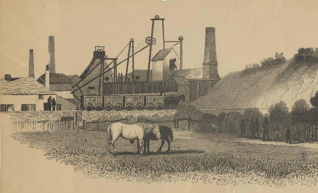
Wideopen Colliery lay in the parish of Long Benton, on the east side of the Great North Road about five and a half miles north of Newcastle. Messrs Perkins and Thackrah began sinking in April 1825, and the first coal was drawn in May 1827. There were two shafts side by side for drawing coal and a third for the pumping engine; the High Main seam, averaging 3 feet 10 inches, lay 80 fathoms down and was the only seam worked, for a 3-foot seam 25 fathoms below was left, and a boring to the Bensham, 76 fathoms below the High Main, found only 10 inches of good coal. The winding engines were of 18 and 24 horsepower and the pumping engine of 74. In November 1833 an engineman, John Gibson, was killed when one of the main pumping engine's boilers burst.
By 1844, when Thomas Hair drew the colliery for his Views of the Collieries, the screens were roofed against the weather and lit at night by gas from a gasometer near the pit, and a 6-horsepower engine drove a saw mill among the workshops. Coal went in half-chaldron rectangular waggons, of a pattern used only here and at Fawdon, 9¾ miles by railway with five stationary engines and several locomotives to the Tyne near Percy Main, and was sold as 'Perkins' Wallsend'. The colliery appears on the first edition Ordnance Survey of the 1860s, with a tunnel and shaft to the north-west that probably served as a secondary way into the mine. The site later became a motor scrapyard, which closed in 2011 for new housing; archaeological work in 2009-19 recorded a colliery winding house at East Wideopen Farm.
Geology
Northumberland coalfield: the High Main seam, about 3 feet 10 inches thick, with a 3-foot seam 25 fathoms below and the Bensham, 10 inches of good coal, 76 fathoms below the High Main.
Workings
Two drawing shafts side by side (A and B Pits) and a pumping shaft; 18 and 24 hp winding engines and a 74 hp pumping engine; a tunnel and shaft to the north-west on the 1860s map.
Closure
Unknown.
What remains
The site was a motor scrapyard until 2011 and has since been redeveloped for housing; a colliery winding house was recorded at East Wideopen Farm.
A colliery winding house at East Wideopen Farm was recorded archaeologically.
Redevelopment
Housing, after the scrapyard that occupied the site closed in 2011.
Nearby mines
- Weetslade Colliery — 0.9 miles (1.4 km) E
- Seaton Burn Colliery — 1.1 miles (1.8 km) NW
- Dudley Colliery — 1.2 miles (1.9 km) NE
- Hazlerigg Colliery — 1.2 miles (2.0 km) W
- Burradon Colliery — 1.5 miles (2.4 km) E, Northumberland
Straight-line distance, within 9 miles (15 km). Show on the map.
What's uncertain
Points where sources disagree or the record could not be settled; both accounts are kept. All open questions in the archive.
- The colliery was linked to the Brunton and Shields Wagonway. (disputed) 2
- Its coal was carried by the Fawdon Wagonway to Scotswood. (disputed) 3
Recorded claims
Individual factual claims, each attached to the source(s) that support it below. Where sources disagree, both are kept.
- Sinking began at Wideopen in April 1825 and the first coals were drawn in May 1827. 1,2,3
- The High Main seam, averaging 3 feet 10 inches, was 80 fathoms down and the only seam worked; a boring to the Bensham, 76 fathoms lower, found only 10 inches of good coal. 1,4
- In 1844 the colliery had workshops, a saw mill and a recently built gasometer lighting the screens at night, with two drawing shafts and a pumping shaft. 1,2
- Its coal went 9¾ miles by railway with five stationary engines to the Tyne near Percy Main, in half-chaldron rectangular waggons, and was sold as 'Perkins' Wallsend'. 1
- The colliery was linked to the Brunton and Shields Wagonway. (disputed) 2
- Its coal was carried by the Fawdon Wagonway to Scotswood. (disputed) 3
- The site became a motor scrapyard, which closed in 2011 to make way for new housing. 2,3
Photographs & further reading
The 1844 account of the colliery, its shafts, engines and railway.
View sourceSources
- (primary) Wideopen Colliery — Durham Mining Museum
- (secondary) Wideopen Colliery (HER 1077) — Tyne and Wear HER (Sitelines)
- (secondary) Wideopen — Wikipedia
- (primary) Wideopen Colliery: strata sunk through in the A and B Pits — Durham Mining Museum
Record created: 5 October 2026 · Last researched: 5 October 2026