 MineArchive
Tower Colliery
| Location | Hirwaun, Cynon Valley, Rhondda Cynon Taf — 51.7270, -3.5550 (exact) |
|---|---|
| Commodity | Coal |
| Type | Coal |
| Worked | From c. 1805–2008 |
| Maximum depth | 160 metres (1941 shaft) |
| Operators | National Coal Board (1947–1994), Goitre Tower Anthracite (1995–2008) |
Overview
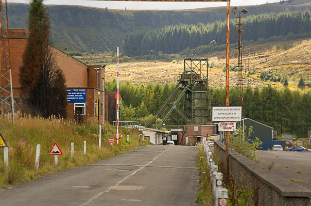
Tower Colliery, on the edge of Hirwaun in the Cynon Valley, closed as uneconomic in 1994 only for 239 of its own miners to buy it back with their redundancy money — reopening it as Britain's first worker-owned coal mine and running it profitably for another thirteen years, making it the last deep mine in Wales when it finally closed in 2008.
History
Coal had been worked around Hirwaun Common since around 1805, and the first drift mine bearing the Tower name was sunk in 1864, taking its name from a nearby folly, Crawshay's Tower, built in 1848. Up to fourteen coal seams were worked across the colliery's lease over its history, and a shaft sunk in 1941 reached a depth of 160 metres; a further drivage, Tower No. 3, was driven in 1958 to serve as the main intake airway. Under nationalised ownership as part of the National Coal Board / British Coal, Tower closed on 22 April 1994 on the grounds that it would be uneconomic to continue, threatening the loss of one of the Cynon Valley's largest employers. Led by NUM branch secretary Tyrone O'Sullivan, 239 miners each pledged £8,000 of their redundancy payouts to buy the colliery outright for around £2 million, forming the Tower Employees Buy-Out (TEBO). Tower reopened on 3 January 1995 under the miners' own company, Goitre Tower Anthracite, as the United Kingdom's first worker-owned deep coal mine. The buyout proved a striking success: in its first full year the workforce produced around 450,000 tonnes of high-grade anthracite and returned a pre-tax profit of over £4 million, working the colliery's Seven Feet/Five Feet seam, which by then offered around 1.3 metres of anthracite within a worked section of 1.65 metres. Tower finally closed on 25 January 2008, after thirteen years of profitable worker ownership, once its accessible coal reserves were exhausted — the last deep coal mine remaining in Wales.
Geology
The colliery worked coal seams of the South Wales Coalfield, a Carboniferous sequence of alternating sandstones, mudstones and coal seams folded into the broad Cynon Valley syncline; by the buyout period only the high-quality anthracite of the Seven Feet/Five Feet seam remained economically workable.
Geological setting: Anticlines and Synclines (historical documentary reference), Sedimentary Beds and Seams (well documented example)
Workings
Up to fourteen seams were developed across the colliery's 221-hectare lease over its working life. A shaft sunk in 1941 reached 160 metres, and Tower No. 3, driven in 1958, served as the mine's main intake airway; a coal washery was added on the surface in the mid-1980s.
Closure
Tower closed as uneconomic under British Coal in 1994, before reopening under worker ownership in 1995 and finally closing for good on 25 January 2008 once its accessible reserves were exhausted.
What remains
The colliery site has been redeveloped as Zip World Tower, an adventure/zip-line attraction built around the former pit's winding gear and headframe.
The colliery's winding gear and headframe survive on site, incorporated into the Zip World Tower attraction; further structures are recorded by Coflein, the Royal Commission on the Ancient and Historical Monuments of Wales.
Related mines
- Duffryn Rhondda Colliery — Tower Colliery later worked the coal reserves left behind when Duffryn Rhondda closed in November 1966 (NMRS).
- Fernhill Colliery — Fernhill's shafts were linked underground to Tower Colliery from 1966, the two collieries working as a single unit.
- Maerdy Colliery — Maerdy operated as an integrated system with Tower Colliery from 1986.
Nearby mines
- Rhydwain Colliery — 1.7 miles (2.8 km) E
- Dunraven Colliery — 2.1 miles (3.5 km) S
- Fernhill Colliery — 2.3 miles (3.7 km) S
- Rhigos Colliery — 2.7 miles (4.3 km) NW, Neath Port Talbot
- Bwllfa Dare Colliery — 2.9 miles (4.7 km) E
Straight-line distance, within 9 miles (15 km). Show on the map.
Disasters & major incidents
-
Tower Colliery explosion, 1962
1962 · Explosion · 9 fatalities
At 10.30 a.m. on 12 April 1962 firedamp exploded in the MC3 heading at Tower Colliery, Hirwaun, as electricians restored power after extending a cable. The heading's auxiliary fan had been stopped for about ninety minutes; nine men resting at the foot of the heading were killed and nine injured.
Culture
- Tower Colliery workers' buyout (Labour)
In 1994-95 the colliery's own miners bought it from British Coal with their redundancy money and ran it as a workers' co-operative until 2008.
Recorded claims
Individual factual claims, each attached to the source(s) that support it below. Where sources disagree, both are kept.
- 239 miners each pledged £8,000 of their redundancy payouts to buy the colliery for around £2 million, forming the Tower Employees Buy-Out and reopening it on 3 January 1995 as the UK's first worker-owned deep coal mine. 1,2
- In its first full year under worker ownership the colliery produced around 450,000 tonnes of high-grade anthracite and returned a pre-tax profit of over £4 million. 1
- A shaft sunk in 1941 reached 160 metres depth, and Tower No. 3, driven in 1958, served as the mine's main intake airway; up to fourteen seams were worked across the colliery's history. 1,3
- Located at about 51.727 N, 3.555 W. 1
Photographs & further reading
An update report from visits between December 2022 and September 2023, made because the most recent account the author could find dated from 2017. Photographs of the lattice-girder headframe over the No. 4 shaft — sunk 495 feet between 1941 and 1944 and used for winding men only — including drone shots, after four attempts defeated by the weather on Rhigos mountain.
View sourceSources
- (secondary) Tower Colliery — Wikipedia
- (secondary) Tower - Coal and Community case study — University of Wolverhampton
- (primary) Tower/Hirwaun Common/Upcast/Bute/River Level and associated mine plans — British Geological Survey / The Coal Authority
Record created: 23 August 2026 · Last researched: 23 August 2026