 MineArchive
Duffryn Rhondda Colliery
| Also known as | Duffryn Navigation Colliery, Dyffryn Rhondda Colliery |
|---|---|
| Location | Duffryn Rhondda (Croeserw), near Cymmer, Afan Valley, Neath Port Talbot — 51.6486, -3.6751 (exact) |
| Commodity | Coal |
| Type | Coal |
| Worked | Levels by 1899; shafts sunk from June 1903–November 1966 |
| Maximum depth | 1,504 yards (1,375 m) at No.2 Pit after the 1960-62 deepening |
| Operators | Duffryn Rhondda Company (?–1903), Duffryn Rhondda Colliery Company Limited (1903–1917), Imperial Navigation Coal Company Limited (1917–1929), Duffryn Rhondda (1929) Limited (1929–1930), Welsh Associated Collieries Limited (1930–1935), Powell Duffryn (1935–1947), National Coal Board (1947–1966) |
Overview
Duffryn Rhondda Colliery, at Duffryn between Cymmer and Croeserw in the upper Afan Valley, was the valley's largest steam-coal pit for most of the twentieth century: two deep shafts sunk from 1903 beside older slants, more than a thousand men on the books in most years from 1910 to closure, a No.2 pit deepened to 1,504 yards in 1962, and an end in November 1966 when the National Coal Board judged its seams unworkable by machine.
History
The colliery stood at Duffryn, between Cymmer and Croeserw in the upper Afan Valley, beside the Rhondda and Swansea Bay Railway. Coflein and Welsh Coal Mines both say it was sunk "sometime prior to 1880" by the Duffryn Rhondda Coal Company as a slant and two shafts; the NMRS account, from Ray Lawrence's work, dates the sinking of the two shafts to June 1903 and gives manpower from 1899, when 143 men were employed, and the railway opened a miners' platform named Duffryn Rhondda Colliery in 1898. The likeliest reading is that the slants into the No.2 Rhondda seam came first and the deep pits followed. The Duffryn Rhondda Colliery Company was registered on 12 January 1903 to take over the older Duffryn Rhondda Company, and sinking began that June: No.1 shaft, the downcast, reached the Gorllwyn seam at 525 yards, and No.2, the upcast, was sunk to the Lower Nine-Feet, the two shafts 45 yards apart and 20 feet in diameter. By April 1907 the local paper was calling it a colliery that would soon be "one of the largest in West Wales", turning out 400 to 500 tons a week from a new pit 530 yards deep; by September it was raising that much a day from the Two-Feet seam, and the workforce, 682 in 1905, passed 950 in 1910 and 1,000 in 1912 (Welsh Coal Mines gives 1,500 by 1910). The company did not survive its own expansion. In February 1914 the colliery was put up for auction at Cardiff and withdrawn after bids of no more than £51,000; the receivers laid off 1,000 men in March, and work restarted at the end of the month under a new agent. By 1917 the pit was in the hands of the Imperial Navigation Coal Company, chaired by Sir D. R. Llewellyn, which also held the neighbouring Cynon Colliery, and in 1918 the pits employed 1,191 men and the levels 190. The NMRS list of small collieries of the Afan Valley records the same colliery under the name Duffryn Navigation, owned by the Imperial Navigation Coal Company and managed by D. J. Rees, with 1,200 men in 1920-24, 1,300 in 1925-26 and 850 in 1929; the colliery's own NMRS page gives 200 and 300 for 1920 and 1922 but 1,590 for 1923 (750 at No.1 pit, 550 at No.2 and 290 at the No.2 slant, raising 360,000 tons), so the smaller figures look like misprints for the same run. Duffryn Rhondda (1929) Limited was formed under Llewellyn in 1929, merged into Welsh Associated Collieries on 29 January 1930, and passed with it to Powell Duffryn Associated Collieries in 1935. In 1920 the pits were working the Seven-Feet at 800 yards and the New (Bute) seam at 811 yards, both dipping at about 20 degrees, with No.1 winding two trams in 60 seconds; the No.2 Rhondda house-coal slant used two electric haulages to bring coal two miles to the surface and was ventilated by a 21-foot Walker fan. Recorded deaths include Edwin Hill, 36, under a roof fall on 6 June 1910, and in 1912 Richard Rees, 32, under a fall, John Edwards, a crane driver found dead on his crane, and Albert Pullen, 27, a haulier killed when the pedestal bolts of a haulage engine broke and a runaway journey ran into a group of hauliers at the foot of an incline. Manpower recovered from 467 in 1930 to 1,420 in 1934, and in 1935 the pits employed 1,250 men underground and 165 on the surface in the Six-Feet, Seven-Feet, New and Four-Feet steam-coal seams, with their own washery. Pithead baths for 1,496 men were built in 1938. Under the National Coal Board from 1947, in the Maesteg Area's Afan Group, the colliery employed a little over 1,000 men through the 1950s and raised 230,000 to 272,000 tons a year from a machine-cut Six-Feet face where each collier had a six-yard stent yielding 22 tons on a 48-hour turnover. From 1959 methane drained from the seams at Duffryn Rhondda, Glyncorrwg and Avon was piped to the Aberavon gasworks to supply 45,000 homes. Cementation deepened No.2 pit between September 1960 and February 1962 to a pit bottom at 1,504 yards, and in June 1963 the downcast winder was electrified at a cost of £133,000. Three years later, in July 1966, the NCB told the union that power loading had failed in the difficult conditions and the pit was losing £4 on every ton; the NUM's case that it was among the most modern collieries in the coalfield with almost unlimited reserves did not save it, and it closed in November 1966. Tower Colliery later worked the reserves it left behind.
Geology
Steam coals of the South Wales Coalfield, classed as type 201B dry steam coal: low volatile, generally non-caking, 5 to 9 per cent ash and 0.6 to 1.5 per cent sulphur, sold for ships', locomotive and power-station boilers. The pits worked the Six-Feet (77 inches with dirt bands), the Bute or 'New' seam (36 inches), the Lower Nine-Feet, called the Seven-Feet here (48 inches), the Four-Feet (48 inches, with partings), the Upper Nine-Feet (30 to 48 inches) and the Lower Pentre, known locally as the Two-and-a-Half (29 inches), with the Gorllwyn at the first shaft bottom; the slants worked the No.2 Rhondda seam of the Upper Coal Series for house coal. The seams at the pits dipped at about 20 degrees, rising to the south. The BGS memoir for the Pontypridd and Maesteg district describes the No.2 Rhondda group splitting locally west of Duffryn, where the lower leaf is known as the Wernddu Rider.
Geological setting: Sedimentary Beds and Seams (historical documentary reference)
Workings
No.1 shaft (downcast) was sunk to the Gorllwyn seam at 525 yards and deepened in 1921 to 708 yards, just below the Six-Feet; No.2 (upcast) to the Lower Nine-Feet, with landings at the No.2 Rhondda level and at 516 yards and a pumping lodge at 360 yards. The two 20-foot shafts were 45 yards apart, with a cross-measures drift to prove the lower seams; Cementation deepened No.2 in 1960-62 to a pit bottom at 1,504 yards (1,375 m). Two slants into the No.2 Rhondda seam ran about two miles underground on electric haulages. A 1920s description gives 110 working places twelve yards apart along a face three-quarters of a mile long, coal moving by horse to a double parting two and a half miles from pit bottom, then by main-and-tail rope and endless-rope haulage along a dead-straight three-track main road, a journey of 25 to 30 trams arriving every twenty minutes. Ventilation was by a 21-foot Walker fan rated at 300,000 cubic feet a minute. By the 1950s the Six-Feet face was undercut by machine to five feet, got with compressed-air picks and loaded by hand onto a scraper-chain conveyor.
Closure
In July 1966 the NCB informed the NUM that attempts to install power-loading equipment had failed in the difficult conditions and the pit was losing £4 on every ton; the union argued that it was one of the most modern collieries in the coalfield with almost unlimited reserves. The colliery closed in November 1966. The Mining Remediation Authority holds abandonment plans for the Six-Feet and Four-Feet dated 11 November 1966 and for the Upper Nine-Feet dated 4 November 1966; Coflein and Welsh Coal Mines give the closure as 1966/7. Tower Colliery later worked reserves the closure left behind.
What remains
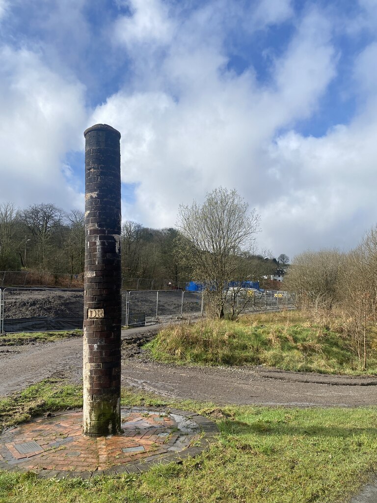
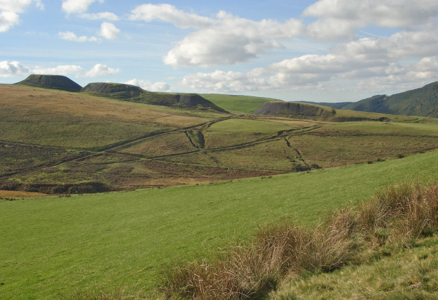
The pit-top has gone. A sculpture beside the site commemorates the colliery; a March 2024 photograph shows it with work under way behind to stabilise the colliery waste. The four great spoil tips on Foel Trawsnant, south of the village, still dominate the view across Cwm Afan in photographs of 2010 and 2024. No underground access or exploration reports have been found.
Four main spoil tips south of Duffryn, together about 600 m north to south and up to 100 m broad, recorded by RCAHMW aerial reconnaissance in 2011 (Coflein NPRN 402097); a memorial sculpture near the pit site; and the trackbed of the Rhondda and Swansea Bay Railway with the site of Duffryn Rhondda Halt, which served the pit's miners from 1898 and closed with the colliery on 7 November 1966.
Redevelopment
The colliery tips were being stabilised in 2024. No other redevelopment of the colliery site has been identified.
Related mines
- Cynon Colliery — Both Cymmer pits were held by the Imperial Navigation Coal Company from 1917-20 to 1929 (Sir D. R. Llewellyn); the Mining Remediation Authority catalogues a combined 'Duffryn Rhondda No.1 & No.2 / Cynon shaft' Six-Feet plan, and the 1,590 men recorded across the company's three Cymmer pits in 1923 are Duffryn Rhondda's own.
- Tower Colliery — Tower Colliery later worked the coal reserves left behind when Duffryn Rhondda closed in November 1966 (NMRS).
Nearby mines
- Cynon Colliery — 1.5 km S
- Tonmawr Colliery — 2.1 km NW
- Caerau Colliery — 2.6 km SE, Bridgend
- Coegnant Colliery — 2.9 km SE, Bridgend
- Whitworth Colliery — 3.0 km W
Straight-line distance, within 15 km. Show on the map.
Recorded claims
Individual factual claims, each attached to the source(s) that support it below. Where sources disagree, both are kept.
- Sunk 'sometime prior to 1880' by the Duffryn Rhondda Coal Company as a slant and two shafts (Coflein; Welsh Coal Mines). (disputed) 1,2
- Manpower is recorded from 1899 (143 men); a miners' railway platform opened as Duffryn Rhondda Colliery in 1898; sinking of the two deep shafts began in June 1903 under the company registered on 12 January 1903. (disputed) 3,4,5
- No.1 shaft (downcast) reached the Gorllwyn seam at 525 yards and was deepened to 708 yards, below the Six-Feet, in 1921; No.2 (upcast) was sunk to the Lower Nine-Feet; the 20-foot shafts were 45 yards apart. 3
- No.2 pit was deepened by Cementation between September 1960 and February 1962 to a pit bottom at 1,504 yards (1,375 m). 3
- The workforce reached 1,500 by 1910 (Welsh Coal Mines; Coflein). (disputed) 1,2
- NMRS manpower: 682 in 1905, 954 in 1910, 1,042 in 1912, 692 at the pits and 426 at the levels in 1913-15. (disputed) 3
- In 1918 the pits employed 1,191 men and the levels or slant 190. 3,1
- Listed as 'Duffryn Navigation Colliery, Cymmer' in the NMRS Afan Valley small-collieries roundup: owned 1920-24 by the Imperial Navigation Coal Company, managed by D. J. Rees, 1,200 men in 1920-24, 1,300 in 1925-26 and 850 in 1929. (disputed) 6
- The NMRS colliery page lists 200 men in 1920, 300 in 1922 and 1924-25, but 1,590 in 1923 (No.1 pit 750, No.2 pit 550, No.2 slant 290) with an output of 360,000 tons; the 200 and 300 figures look like misprints for 1,200 and 1,300. (disputed) 3
- The Duffryn Rhondda Colliery Company was registered on 12 January 1903 to take over the Duffryn Rhondda Company; in February 1914 the colliery was auctioned at Cardiff and withdrawn at bids of £40,000 to £51,000, and the receivers laid off 1,000 men in March 1914. 3,4
- Owned by the Imperial Navigation Coal Company by 1917-18; Duffryn Rhondda (1929) Limited formed 1929 under Sir D. R. Llewellyn; merged into Welsh Associated Collieries on 29 January 1930; to Powell Duffryn Associated Collieries in 1935; to the National Coal Board on 1 January 1947 (South Western Division, No.2 Maesteg Area, Afan Group). 3,1,4
- Edwin Hill, 36, was killed by a roof fall on 6 June 1910; in 1912 Richard Rees (12 April, roof fall), John Edwards (2 September, found dead on his crane) and Albert Pullen (22 October, runaway haulage journey) died at the colliery. 3
- Pithead baths for 1,496 men were built in 1938; the downcast winding engine was electrified in June 1963 at a cost of £133,000. 3
- In the 1950s the colliery employed 1,030 to 1,140 men and raised 216,000 to 272,000 tons a year; from 1959 methane from Duffryn Rhondda, Glyncorrwg and Avon was piped to the Aberavon gasworks to supply 45,000 homes. 3
- In July 1966 the NCB told the NUM that power loading had failed and the pit was losing £4 a ton; it closed in November 1966. Abandonment plans for the Six-Feet and Four-Feet are dated 11 November 1966. 3,7
- Coflein and Welsh Coal Mines give the closure as 1966/7. (uncertain) 1,2
- The coals were type 201B dry steam coals; the pits worked the Six-Feet, Bute (New), Lower Nine-Feet (Seven-Feet), Upper Nine-Feet, Four-Feet, Lower Pentre (Two-and-a-Half) and Gorllwyn seams, the slants the No.2 Rhondda. 3
- The No.2 Rhondda seam group splits locally in the Afan Valley west of Duffryn, where the lower leaf is known as the Wernddu Rider (BGS district memoir, which does not name the colliery). 8
- Four main spoil tips south of the colliery, together about 600 m north-south and 100 m broad, were documented by RCAHMW aerial reconnaissance in 2011 and photographed in 2010 and 2024. 9,10
- A sculpture near the site commemorates the colliery; a March 2024 photograph shows work in progress to stabilise the colliery waste behind it. 11
- Tower Colliery later worked the coal reserves left behind by the closure of Duffryn Rhondda. 3
Photographs & further reading
The RCAHMW site record with the ten-figure grid reference and a 2011 summary.
View sourceAerial-survey record of the four tips south of the village with their dimensions.
View sourceCompany registration of 1903 and the 1930 amalgamation agreement, from the Stock Exchange Year Book and National Archives.
View sourceShort history with photographs of the pits in the 1930s and 1960s and a 1918 workforce group.
View sourceThe tips seen from Foel Penycastell, with links to two further photographs of the same heaps.
View sourceThe memorial sculpture near the site, with tip-stabilisation work in progress behind it.
View sourceThe Rhondda and Swansea Bay Railway halt that served the colliery's miners from 1898 until the pit closed in November 1966.
View sourceRay Lawrence's full account: shaft depths, seams, ownership, the 1914 receivership, named deaths, a year-by-year manpower and output list to 1964, and the 1966 closure.
View sourceSources
- (secondary) Duffryn Rhondda Colliery, Cymmer — Welsh Coal Mines
- (primary) Dyffryn Rhondda Colliery; Duffryn Rhondda Colliery (NPRN 80557) — Coflein / RCAHMW
- (secondary) Duffryn Rhondda Colliery — Northern Mine Research Society (Ray Lawrence)
- (secondary) Duffryn Rhondda Colliery Co — Grace's Guide to British Industrial History
- (secondary) Duffryn Rhondda Halt railway station — Wikipedia
- (secondary) Small Collieries in the Afan Valley and surrounding areas — Northern Mine Research Society
- (primary) BGS / Mining Remediation Authority mine plans: DUFFRYN RHONDDA, Six Feet, abandoned 11 November 1966 (SWA780) — British Geological Survey / Mining Remediation Authority
- (primary) Geology of the South Wales Coalfield Part IV, the country around Pontypridd and Maesteg — British Geological Survey
- (primary) Duffryn Rhondda Colliery Spoil Heaps, S of Dyffryn (NPRN 402097) — Coflein / RCAHMW
- (observational) Duffryn Rhondda Colliery spoil heaps, Foel Trawsnant (photograph, 16 October 2010) — Geograph (eswales)
- (observational) Duffryn Rhondda Colliery sculpture (photograph, March 2024) — Geograph (Alan Hughes)
Record created: 14 September 2026 · Last researched: 16 September 2026