 MineArchive
Red Scar Mine
| Location | near Grimwith Reservoir, east of Hebden, North Yorkshire — 54.0948, -1.9166 (exact) |
|---|---|
| Commodity | Lead |
| Type | Metal |
| Worked | 1862–1877 |
| Maximum depth | Unknown. |
| Operators | Grimwith Mining Company (1862–1877) |
Overview
A short-lived Victorian lead mine in Upper Wharfedale, developed by the Grimwith Mining Company from 1862 on the strength of nearby success at Grassington Moor and Greenhow, and abandoned within fifteen years once flooding and poor ore proved the venture unviable.
History
The Grimwith Mining Company signed a 21-year lease on the Red Scar site, near Grimwith Reservoir some two miles east of Hebden, in 1862, encouraged by the rich veins already being worked nearby on Grassington Moor and at Greenhow, as well as smaller operations at Appletreewick and Hebden Gill. An office and lodge house were built around 1867 to house workers at the remote site, the company's directors expressing confidence to shareholders that proved misplaced: flooding and poor-quality veins forced the mine's closure in 1877, only fifteen years into the lease. Underground the venture is still legible: Red Scar Level, begun in 1863, runs in for about half the length its plan shows before a collapse near a shaft junction, and a second level on one of the east-west veins can be followed past partial collapses to workings once reached from a surface shaft, with a little coal met on the way. A level near the water is probably drowned, the reservoir having been enlarged in the 1970s.
Geology
Lead of the Wharfedale orefield near Grimwith; the vein is not named on the record.
Workings
Targeted lead veins in the same mineralised ground as Grassington Moor and Greenhow; ore dressing was carried out at an on-site dressing floor, one of the last built anywhere in the Yorkshire Dales.
Closure
Closed in 1877, only fifteen years into the Grimwith Mining Company's 21-year lease, after flooding and poor-quality veins made the operation unviable.
What remains
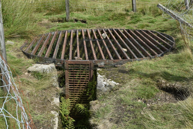
The ruined office building and lodge house, with a distinctive first-floor oriel window overlooking the site, still dominate the location; a shaft nearby has been fitted with a protective cage over an earlier fence.
The ruined office/lodge building and at least one capped/caged shaft.
Nearby mines
- Grassington Moor Mines — 1.9 miles (3.0 km) W
- Frankland Fold Mine — 2.3 miles (3.7 km) W
- Stony Grooves Mine — 2.8 miles (4.5 km) E
- Beever Mine — 3.3 miles (5.3 km) W
- Greenhow Mines — 3.8 miles (6.0 km) E
Straight-line distance, within 9 miles (15 km). Show on the map.
Recorded claims
Individual factual claims, each attached to the source(s) that support it below. Where sources disagree, both are kept.
- The Grimwith Mining Company signed a 21-year lease on Red Scar in 1862; the mine closed in 1877, only fifteen years in, after flooding and poor-quality veins. 1
- A shaft at the site, previously only fenced, has since been fitted with a protective metal cage. 2
- The Grimwith Mining Company's directors expressed confidence to shareholders about the venture's prospects, confidence that proved misplaced once flooding and poor veins forced closure. 1
- An explorer in March 2025 recorded the levels of the Red Scar (or Grimwith) mine on the moors above Grimwith Reservoir, alongside those of the Old Prosperous (Groove Gill) mine, as attempts on the veins between Grassington Moor and Ashfold Side that found some ore but had shut by 1877. Red Scar Level, driven from 1863, is open for about half the length shown on the mine plan, ending at a collapse near a junction and a descending shaft, with sticks across the roof perhaps for air ducting; another level targeting an east-west vein is mostly accessible past several partial collapses, with a way up to strata once worked from a surface shaft and a crawling offshoot coal level; one level near the reservoir is probably below the waterline since the reservoir was enlarged in the 1970s. 3
Photographs & further reading
The Yorkshire Dales National Park's own gazetteer entry, the main source for this record.
View sourceSources
- (primary) Red Scar lead mine and ore works — Out of Oblivion (Yorkshire Dales National Park)
- (observational) Closed shaft at Red Scar Lead Mine (Geograph) — Geograph Britain and Ireland
- (observational) Mines 55 - Grimwith Lead Mines, Yorkshire, 2025 (28DaysLater, urbanchemist) — 28DaysLater
Record created: 31 August 2026 · Last researched: 24 September 2026