 MineArchive
Stony Grooves Mine
| Also known as | Stoney Groove, Merryfield Hole, Hirefeldberg Mine, Ramsgill Lead Mine |
|---|---|
| Location | Ashfold Side, Bewerley, Nidderdale, North Yorkshire — 54.0933, -1.8332 (approximate) |
| Commodities | Lead, Barite |
| Type | Metal |
| Worked | 13th century–1889 |
| Maximum depth | The New Shaft at Merryfield Hole was sunk 55 fathoms (about 100 m). |
| Operators | Byland Abbey (1200–1540), John Homer and Company (1800–?), Ransgill Mining Company Ltd (1873–?), Bewerley United Lead and Barytes Mining Company (1887–1889) |
Overview
Lead mines on both banks of Ashfold Side Beck in Nidderdale, where the working runs from medieval hushing to a Cornish boiler and a steam pump. Byland Abbey mined the north side from the 13th century; the Stony Grooves leases on the south are first mentioned in 1705, and the two were finally worked as one venture until the cost of draining the deep levels closed them in 1889.
History
Ashfold Side Beck marks the ancient boundary between two mineral royalties, and the two halves of the mine have separate histories because of it. On the north side, the ground at Merryfield Hole is recorded as Hirefeldberg mine, worked by Byland Abbey from the 13th century into the 16th; that mining is thought to have been surface work, and shows as the hushed opencuts there. The Stony Grooves mines on the south side are first mentioned in 1705 but were well established by then, worked by regularly spaced shallow shafts and small opencuts along the top of the vein. John Homer and Company were working Merryfield by 1800, and by 1826 a New Shaft had been sunk at Merryfield Hole, opposite the Stony Grooves site, 55 fathoms deep and equipped with a Cornish boiler plant and a steam pump until the Wonderful Level could be driven up to it. Through the 19th century the leases were worked in tandem by a series of independent partnerships, the mines concentrating around single shaftheads in the late 18th and early 19th centuries and taking steam power later; the Ransgill Mining Company Ltd was formed in 1873 to work High and Low Stony Groove, leased from Barnaby and Hutchinson, and the Bewerley United Lead and Barytes Mining Company followed in 1887 and later bought the mineral rights. Ore was carried from High Stony Grooves to the dressing floors at Low Stony Grooves on a tramway along the top of Ashfold Gill. In the last years Merryfield Hole was combined with Stony Grooves and worked as a single venture, and the rising cost of draining the lower levels brought final closure in 1889, the company winding up that year.
Geology
The lead-bearing veins run in the Millstone Grit of the Namurian, roughly down the line of Ashfold Gill: the Bycliffe vein of Grassington Moor, having run some eight miles east, becomes the Stony Groove and Providence veins here, both trending north-west to south-east. The oldest rocks on the north-east side of the fault are the Red Scar Grit with the Follifoot Grits.
Workings
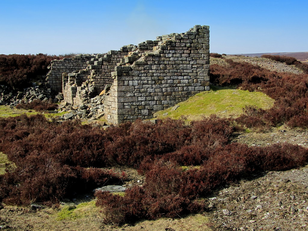
The monument falls in nine separate areas along both sides of the beck. In the west, on the south bank, Upper Stony Grooves shows three phases in one place: opencut working directly on the vein, with shallow surface workings, spoil tips and the remains of small huts; then regularly spaced shallow shafts along the top of the vein; then the concentration of the mine on a single shafthead. At Merryfield Hole the distinctive hushed opencuts are the mark of the medieval working. The dressing floors at Low Stony Grooves are the only ones left in recognisable form on the Greenhow field, being the last to be worked and probably laid out by the Bewerley United company: they are set out on four levels, the first with two bouse teams taking ore from the shaft head, the second holding part of the water wheel pit and probably a trommel or other sizing machinery, the third centred on the water wheel with the crusher and jigging machinery, and the lowest for treating the fines, where the remains of a centre-head buddle survive — possibly the only one ever built on the field. Part of the water supply system that served all this is scheduled with the mines.
Closure
Working was intermittent for centuries and ended for good in 1889, when the increasing cost of draining the lower levels defeated the Bewerley United Lead and Barytes Mining Company and it wound up.
What remains
The ruins, earthworks and buried remains are a scheduled monument in nine areas of protection on unenclosed moorland. The dressing floors at Low Stony Grooves survive in recognisable form with their bouse teams, wheel pit and centre-head buddle; ore storage compartments stand above the beck, and a lead mining trail runs through the valley, which is a well-known walking spot. Explorers' reports of 2025 and 2026 describe the underground workings along this stretch of the vein as still enterable in places.
Hushed opencuts at Merryfield Hole, shallow shafts and opencuts along the veins, shaft mounds, the ruins of small huts, the four-level dressing floors at Low Stony Grooves with bouse teams, wheel pit and centre-head buddle, the tramway line along Ashfold Gill, and leats and dams of the water system.
Redevelopment
None. The site is unenclosed moorland either side of Ashfold Side Beck.
Related mines
- Prosperous Lead Mine — The Prosperous smelt mill served the Stony Grooves and Providence mines as well as its own, and when Prosperous was given up in 1873 its plant was sold and reused at Stony Grooves and Merryfield.
Nearby mines
- Prosperous Lead Mine — 1.0 km E
- Greenhow Mines — 1.8 km S
- Coldstones Quarry — 3.9 km W
- Scotgate Ash Quarry — 5.0 km E
- Red Scar Mine — 5.6 km SW
Straight-line distance, within 15 km. Show on the map.
Recorded claims
Individual factual claims, each attached to the source(s) that support it below. Where sources disagree, both are kept.
- The Merryfield Hole area, known as Hirefeldberg mine, was mined by Byland Abbey from the 13th century into the 16th, the working of that period taking the form of surface extraction shown by the hushed opencuts. 1
- The Stony Grooves mines on the south side of the beck are first mentioned in 1705 but were well established by that date. 1
- By 1826 the New Shaft at Merryfield Hole had been sunk 55 fathoms deep and equipped with a Cornish boiler plant and a steam pump, until the Wonderful Level could be driven up to it. 2
- The Ransgill Mining Co. Ltd was formed in 1873 to work High and Low Stony Groove, leased from Barnaby and Hutchinson, and the Bewerley United Lead and Barytes Mining Company followed in 1887 and later bought the mineral rights. 2
- The increasing cost of draining the lower levels led to final closure in 1889. 1,2
- The dressing floors at Low Stony Grooves are the only ones remaining in recognisable form on the Greenhow field, set out on four levels and including the remains of a centre-head buddle, possibly the only one built on the field. 2
Photographs & further reading
Les Bloom's account of a 2007 excursion to the mines, with the succession of companies from John Homer to Bewerley United, the New Shaft of 1826 and a description of the four-level dressing floors.
View sourceA database record for the Merryfield workings listing the succession of lessees from 1537 onwards and the published literature on the Greenhow lead field.
View sourceSources
- (primary) Stony Grooves and Merryfield Hole lead mines, Bewerley (List entry 1018223) — Historic England
- (secondary) Stoney Groove and Merryfield Lead Mining area, Greenhow (Les Bloom) — Upper Wharfedale Field Society
- (observational) Mines 61 — Ashfold Side Lead Mines, Yorkshire, 2025–2026 — 28DaysLater
Record created: 22 September 2026 · Last researched: 22 September 2026