 MineArchive
Prince Edward Gold Mine
| Also known as | Moel Croesau Mine, Prince Edward Mine, Moel y Croesau Mine, Bwlch y Llu |
|---|---|
| Location | Moel y Croesau, about 4 km north-east of Trawsfynydd, Merioneth, Gwynedd — 52.9293, -3.8698 (approximate) |
| Commodity | Gold |
| Type | Metal |
| Worked | Recorded 1895 (as Moel Croesau)–1935 |
| Maximum depth | Unknown; the workings include flooded winzes below the main adit and stopes rising towards shallow upper workings. |
Overview
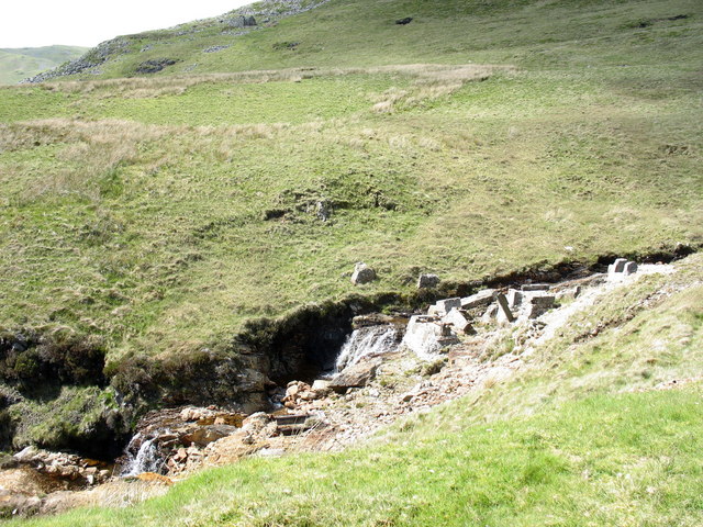
A small, remote gold mine on the slopes of Moel y Croesau, about four kilometres north-east of Trawsfynydd, isolated some six miles north of the rest of the Merioneth gold belt. First recorded in 1895 as Moel Croesau, it was worked on and off until 1935 and yielded 278 ounces of gold from 123 tons of ore, most of it in 1911-12. Its gold is said to have gone into a bar from which royal wedding rings were made. Its drainage adit, strongroom, miners' barracks and river-bed mill foundations survive on open access land.
History
The mine sits on Moel y Croesau, the 'hill of crosses', and first appears in the record in 1895 under that name; one trip report suggests it was probably first worked around 1885. It was later called Prince Edward, and also Prince of Wales and Bwlch y Llu. It was worked sporadically until 1935. The recorded output was 123 tons of gold ore yielding 278 ounces of gold, most of it during 1911 and 1912, its most productive period; the gold came in pockets said to have been very rich. The veins also carry sphalerite, galena and chalcopyrite with quartz and pyrite, but only the gold was developed. Mindat, citing T.A. Morrison's Goldmining in Western Merioneth and G.W. Hall's The Gold Mines of Merioneth, says the gold for Princess Marina's wedding ring, and for later royal rings, came from a bar made jointly of gold from this mine, Marina Mine and the Roman Deep at Dolaucothi. It dates that to 1935, though the wedding itself took place in November 1934. Trip reports add that gold for the regalia of Edward's investiture as Prince of Wales in 1911 came from the mine and gave it its name; Mindat does not say so, and that detail is unconfirmed here. The mine was remote, and its workmen lived in barracks beside it during the week and went home to their families at weekends. Its mill stood in and beside the river, with a rock crusher, stamps, a vibrating table and slimes boxes driven by a waterwheel. Inside the main adit a strongroom was built with an iron gate and a second set of steel doors, which a local story says a farmer later blew off with dynamite in search of gold.
Geology
Gold in quartz veins with pyrite, and some sphalerite, galena and chalcopyrite; black manganese-like deposits and traces of copper coat much of the mine. It is the most northerly mine of the Dolgellau (Merioneth) gold belt.
Geological setting: Veins and Lodes (historical documentary reference)
Workings
A main drainage adit by the river leads past a strongroom to cross-cuts, stoped ground rising at an angle, two flooded winzes (one with the remains of a pulley and an incline with rails) and an air winch base, and connects with shallow upper workings entered at SH 7446 3868, allowing a through trip. On the surface Coflein maps workings over about 550 by 430 metres, with levels and spoil heaps along the river for about 400 metres and linear workings on the higher ground to the south and east.
Closure
Worked sporadically from the 1890s and closed in 1935; the most productive years were 1911-12.
What remains
A ruin on open access land. The adit is gated with a narrow gap, and inside it is wet with collapses, a water-filled passage behind a rock fall and flooded winzes. The strongroom's inner steel doors lie twisted. A large pyrite boulder at the top entrance has been drilled and smashed.
A concrete-rendered brick office and store, the row of miners' barracks, a possible powder store, concrete foundation blocks of the mill in the river bed, and waterwheel foundations straddling the stream.
Redevelopment
None; pylon refurbishment work in the 2010s laid a rough hardcore track that eases the walk up.
Related mines
- Dolaucothi Gold Mines — Gold from Dolaucothi was combined with Prince Edward's into the bar used for royal rings.
- Gwynfynydd Gold Mine — Both belong to the Merioneth gold belt; Gwynfynydd lies about six miles to the south.
Nearby mines
- Gloddfa Ganol Quarry — 7.1 km NW
- Manod Quarry — 7.1 km N
- Graig Ddu Quarry — 7.3 km N
- Rhiwbach Quarry — 7.6 km N
- Blaen y Cwm Quarry — 7.8 km N
Straight-line distance, within 15 km. Show on the map.
What's uncertain
Points where sources disagree or the record could not be settled; both accounts are kept. All open questions in the archive.
- One trip report says the mine was probably first worked around 1885. (uncertain) 3
- Mindat dates the ring bar to 1935; Princess Marina married in November 1934. (disputed) 7
- Two trip reports say gold for Edward's 1911 investiture as Prince of Wales came from the mine and gave it its name; Mindat does not mention this. (uncertain) 3,5
Recorded claims
Individual factual claims, each attached to the source(s) that support it below. Where sources disagree, both are kept.
- Recorded output was 123 tons of gold ore producing 278 oz of gold, most of it in 1911-1912. 1,2
- The mine was worked from 1895 to 1935; it was first referred to in 1895 under the name Moel Croesau. 1,2
- One trip report says the mine was probably first worked around 1885. (uncertain) 3
- Coflein records gold mine workings covering about 550 m east-west by 430 m north-south, the main mine buildings at SH 7425 3851, and the remains of a waterwheel and dressing-plant foundations. 4
- Inside the adit is a strongroom with an iron gate; its second, inner steel doors were blown off, reportedly by a local farmer looking for gold. 1,2
- The mill by the river had a rock crusher, Canadian stamps, a vibrating table separator and slimes boxes, with a waterwheel. 1
- Because the mine was remote, the workmen lived in barracks beside it during the week and returned home at weekends. 5
- The BGS holds a coloured plan of Prince Edward Mine among its gold mine plans for Gwynedd. 6
- Gold for Princess Marina's wedding ring, and subsequent royal rings, came from a bar made jointly from Prince Edward, Marina Mine and Roman Deep (Dolaucothi) gold. 1,7
- Mindat dates the ring bar to 1935; Princess Marina married in November 1934. (disputed) 7
- Two trip reports say gold for Edward's 1911 investiture as Prince of Wales came from the mine and gave it its name; Mindat does not mention this. (uncertain) 3,5
- Mindat records 123 tons of gold ore yielding 278 oz, the majority between 1911 and 1912, and places the mine with Cwmprysor as the most northerly of the Merioneth gold mines. 7
Photographs & further reading
Trip report with photographs underground, including the strongroom doors and flooded incline.
View sourceTrip report with a set of underground photographs of drives, stopes and winzes.
View sourceRCAHMW site record mapping the extent of the workings, mill remains and buildings.
View sourceUnderground description of the adit, strongroom, winzes and stopes, surface remains and a 27-item bibliography.
View sourceLocality page with a short history, output figures, the royal-ring bar and references to Morrison and Hall.
View sourceSources
- (secondary) Prince Edward — Buddlepit Mine Database
- (observational) Prince Edward Goldmine, Trawsfynydd, Wales, Jan 2015 — 28DaysLater (The Kwan)
- (observational) Prince Edward Gold mine, Trawsfynydd, North Wales, July 2021 — 28DaysLater (HughieD)
- (secondary) Prince Edward Gold Mine, Moel Croesau, near Trawsfynydd (NPRN 33985) — RCAHMW Coflein
- (observational) Prince Edward Goldmine, Trawsfynydd, North Wales, March 2022 — 28DaysLater (cunningcorgi)
- (primary) BGS mine plans: PRINCE EDWARD MINE (gold, Gwynedd) — British Geological Survey
- (secondary) Prince Edward Mine (Moel Croesau), Trawsfynydd, Gwynedd, Wales, UK — Mindat.org
Record created: 17 September 2026 · Last researched: 17 September 2026