 MineArchive
Polkemmet Colliery
| Location | Whitburn, West Lothian — 55.8580, -3.7040 (exact) |
|---|---|
| Commodity | Coal |
| Type | Coal |
| Worked | 1913 (sinking)–1986 (flooded 1984) |
| Maximum depth | 477m (No. 1 shaft); 479m (No. 2 shaft) |
| Operators | William Dixon Ltd (1913–1947) |
Overview
A major 20th-century deep coal mine at Whitburn, West Lothian, known locally as 'The Dardanelles', sunk 1913-21 by William Dixon Ltd and later run by the National Coal Board. Described by Historic Environment Scotland as Scotland's most important pit in terms of longevity and workforce, it supplied coking coal to Ravenscraig steelworks before flooding during the 1984-85 miners' strike — in disputed circumstances — forced its closure in 1986. Part of the wider estate is now Polkemmet Country Park, though that park in fact occupies the separate, adjoining Polkemmet House grounds rather than the colliery's own site.
History
Two shafts were sunk at Whitburn by William Dixon Ltd: No. 1 (upcast) in 1913 and No. 2 (downcast) in 1916, with production of coking and gas coal beginning in 1921. Ownership passed to the National Coal Board on nationalisation in 1947. A 1948 inspection recorded output of 1,320 tons a day from 981 employees, worked by longwall methods and processed through a Baum-type washer, with pithead baths dating from 1937. A major reconstruction in the mid-1950s replaced steam winding with electric winders and skip winding, and added new preparation, compressor and administration plant; the colliery's pithead baths became the second largest in Scotland, and its workforce peaked at 1,959 men in 1960 — by which measure, and by longevity, Historic Environment Scotland describes it as Scotland's most important pit. In its later years the colliery was a major supplier of coking coal to Ravenscraig steelworks at Motherwell, a role raised directly in the House of Commons when its closure was debated.
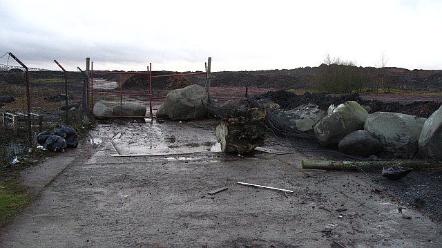
The colliery flooded at the end of August 1984, during the national miners' strike, after safety cover was withdrawn and pumping stopped; all underground equipment was damaged. A July 1985 Commons debate on the closure was sharply contested: the minister blamed 'the withdrawal of safety cover by the NUM', calling it 'that disgraceful act of vandalism', while the opposing MP argued NCB management had itself prevented maintenance of the kind carried out at other pits, and that Polkemmet could technically still be reopened. Historic Environment Scotland records the closure plainly as having occurred 'in controversial circumstances as a result of flooding'; the colliery formally closed in 1986. Afterward, spontaneous combustion in the spoil bing produced fumes 'instantly recognisable to regular travellers on the M8 motorway' when carried on the prevailing wind, until the site was later cleared by opencast recovery and land reclamation.
Older, smaller-scale workings predate the 20th-century colliery on the same ground: BGS mine plans separately record 'Harthill and Polkemmet' (Boghead Gas seam, abandoned 1879) and 'West Benhar, Polkemmet, Harthill, Benhar Nos. 1 & 3' (ironstone seams, abandoned 1883), evidence of earlier extraction before the main colliery was sunk.
Geology
Coal of the West Lothian field, on ground where ironstone seams had been worked and abandoned by 1883.
Workings
Two shafts, both 6.1 metres in diameter: No. 1 (upcast), 477 metres deep, sunk 1913; No. 2 (downcast), 479 metres deep, sunk 1916. The colliery worked coking and gas coal by longwall methods, with surface plant including a Simon Carves preparation plant and washer, compressor plant, locomotive shed, electrical workshop and administration block; its boilerhouse chimney was demolished in 1970.
Closure
The site underwent opencast coal recovery and land reclamation after closure.
What remains
The colliery site underwent opencast coal recovery and land reclamation after closure. Polkemmet Country Park, opened to the public in 1981, occupies the separate, adjoining Polkemmet House estate rather than the colliery's own footprint, and today includes a golf course, woodland walks and the Scottish Owl Centre.
Related mines
- Blairmuckhill Colliery — Neighbouring pits of the Harthill and Whitburn district.
- Whitrigg Colliery — Neighbouring West Lothian pits at Whitburn, working the same coalfield.
Nearby mines
- Southrigg Colliery — 0.5 miles (0.8 km) SW
- Greenrigg Colliery — 1.0 miles (1.7 km) SW
- Greenrigg Pit — 1.0 miles (1.7 km) SW
- Crofthead Colliery — 1.6 miles (2.6 km) SE
- Benhar Colliery — 1.7 miles (2.7 km) SW
Straight-line distance, within 9 miles (15 km). Show on the map.
Recorded claims
Individual factual claims, each attached to the source(s) that support it below. Where sources disagree, both are kept.
- No. 1 shaft (upcast) was sunk in 1913 and No. 2 (downcast) in 1916, both 6.1 metres in diameter and reaching 477 and 479 metres respectively; production began in 1921. 1
- The workforce peaked at 1,959 men in 1960; by longevity and workforce, Historic Environment Scotland describes Polkemmet as Scotland's most important pit, with the second-largest pithead baths in the country. 1
- The colliery flooded at the end of August 1984 after safety cover and pumping were withdrawn during the miners' strike; a July 1985 Commons debate saw the government blame the NUM for withdrawing safety cover while the opposing MP argued NCB management had itself prevented maintenance, and that the pit could technically be reopened. The colliery formally closed in 1986. 1,2
- BGS mine plans record older, separate workings on the same ground pre-dating the 20th-century colliery: 'Harthill and Polkemmet' (Boghead Gas seam, abandoned 1879) and 'West Benhar, Polkemmet, Harthill, Benhar Nos. 1 & 3' (ironstone seams, abandoned 1883). 3
- Polkemmet Country Park, opened to the public in 1981 on the separate, adjoining Polkemmet House estate bought by West Lothian District Council from the NCB in 1978, is not the same site as the colliery itself, which remained working for a further five years after the park opened. 4
Sources
- (primary) Polkemmet Colliery — Historic Environment Scotland (Canmore)
- (primary) Polkemmet Colliery, HC Deb 15 July 1985 — UK Parliament (Hansard)
- (primary) Polkemmet mine plan records — British Geological Survey / Coal Authority mine plans catalogue
- (secondary) Polkemmet Country Park — Wikipedia
Record created: 26 August 2026 · Last researched: 26 August 2026