 MineArchive
Nangiles Mine
| Also known as | Wheal Nangiles, Nangiles and Bread and Cheese Mine |
|---|---|
| Location | Twelveheads, near Chacewater, Cornwall — 50.2362, -5.1363 (approximate) |
| Commodities | Copper, Pyrite, Tin, Zinc |
| Type | Metal |
| Worked | by 1808–1915 |
| Maximum depth | 160 fathoms (c. 293 m) by 1870 |
| Operators | Falmouth Consolidated (1906–1916) |
Overview
A substantial 19th-century copper, tin and zinc mine at Twelveheads near Chacewater, worked from at least 1808, closed in 1848, reopened in 1862 with a new 80-inch pumping engine, and later absorbed into Falmouth Consolidated Mines. Its own drainage adit was the point through which the abandoned Wheal Jane workings released their notorious 1992 acid mine water discharge.
History
Nangiles was already at work by 1808, when it was known as Nangiles and Bread and Cheese Mine and was recorded as producing large quantities of copper, tin and zinc using a steam engine; a mine plan surviving from around 1810 shows a line of costean pits worked east-west along the old tin lode, suggesting activity here reaches back further still, though no firm earlier date can be confirmed. By 1819 the workings had reached 70 fathoms (about 128 m), but copper output was already falling behind that of neighbouring mines. The mine worked on into the 1840s before closing in 1848 alongside Wheal Andrew, a neighbouring mine on the opposite side of the river; blende (zinc ore) was sold from the site in 1856, but this did not lead to a sustained reopening. Nangiles resumed work properly in 1862, when a new 80-inch pumping engine was erected on Engine Shaft. By 1864 the mine also had a 30-inch stamps engine and a winding engine, and had reached 117 fathoms below adit; a separate 36-inch stamps engine, installed in 1871 by the Welsh Gold Mining Company and driving 84 stamp heads, was later sold on to West Condurrow in 1891 and ended up at Wheal Grenville. By 1870 the mine was 160 fathoms deep, employed around 90 people, and was chiefly productive of pyrite with some blende rather than copper. The mine water was so corrosive that the pumps had to be lined with brass, an expense that Hamilton-Jenkin records as a serious financial burden on the company. The 80-inch engine worked for about ten years before being sold to Wheal Rose United in 1872 and moved on again to Holmbush Mine in 1874; the ruined engine house on Engine Shaft was largely demolished in 1967, leaving only the bob wall standing. In 1906 Nangiles was brought into Falmouth Consolidated Mines alongside Wheal Jane, West Wheal Jane and Wheal Widden, and worked as part of that group until it was wound up in 1915–16. The Wheal Jane group investigated and worked the ground for tin again in 1969–79 and 1980–91, alongside its own much larger operation nearby. Wheal Jane's underground workings are connected to Nangiles's own drainage adit, and it was through this Nangiles Adit that the flooded, abandoned Wheal Jane mine released its acid mine water in the January 1992 discharge (see Disasters, below).
Geology
Nangiles worked the Mundic (or Baldu) and Nangiles Copper lodes, part of the same hydrothermally mineralised system of steep, roughly east-west vein lodes worked across the wider Gwennap/Chacewater district, carrying copper and tin near surface giving way to pyrite-rich ground at depth.
Geological setting: Veins and Lodes (well documented example)
Workings
Recorded shafts include Engine Shaft (130 fathoms/c. 234 m, site of the 1862 pumping engine), Bread and Cheese Shaft (90 fathoms/c. 165 m), Phillip's Shaft, Tregonning's Shaft, Little Bread and Cheese Shaft and Crane Shaft. The workings were closely tied to the neighbouring Bread and Cheese Mine, worked as a single concern with Nangiles from at least 1808.
Closure
Regular working ended with Falmouth Consolidated's closure in the mid-1910s; later 20th-century activity was limited to prospecting and investigation by the Wheal Jane group rather than sustained production.
What remains
A 2007 underground exploration report (28DaysLater) accessed the workings via Bread and Cheese Shaft and described extensively collapsed and unstable ground, rotten timbering and poor air in places — conditions consistent with a long-abandoned, unmaintained mine rather than anything safe to enter.
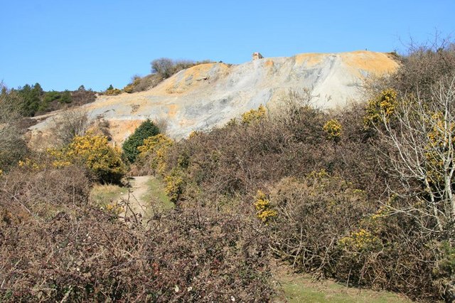
The principal surface feature is the large, distinctively coloured spoil ("burrow") heap running from Engine Shaft down towards the route of the former Redruth and Chacewater Railway, now the Bissoe Valley/Mineral Tramways trail. The top of the demolished engine house's bob wall is still visible at the crest of the spoil heap; the site lies on CRoW open-access land.
Related mines
- Wheal Grenville — An engine from Nangiles was sold on to West Condurrow in 1891 and eventually ended up at Wheal Grenville.
- Wheal Jane — Nangiles' own drainage adit was the exact point through which Wheal Jane's flooded workings released their notorious 1992 acid mine water discharge.
Nearby mines
- Great County Adit — 0.2 miles (0.3 km) SW
- Mount Wellington Mine — 0.4 miles (0.6 km) W
- Cusvey Mine — 0.5 miles (0.8 km) W
- Wheal Jane — 0.6 miles (1.0 km) NE
- Wheal Clifford — 1.1 miles (1.8 km) W
Straight-line distance, within 9 miles (15 km). Show on the map.
Disasters & major incidents
-
Wheal Jane acid mine water discharge, 1992
13 January 1992 · Flooding / Inundation · 0 fatalities
An estimated 50,000 m³ of acidic mine water burst from the flooding, abandoned Wheal Jane workings and turned the Carnon River and Fal estuary ochre-yellow — one of the most notorious mine-water pollution incidents in British history, and one still being actively treated more than three decades later.
What's uncertain
Points where sources disagree or the record could not be settled; both accounts are kept. All open questions in the archive.
- By 1864 the mine had reached 117 fathoms below adit and was equipped with a 30-inch stamps engine and a winding engine in addition to the pumping engine; a separate 36-inch stamps engine was installed in 1871 by the Welsh Gold Mining Company, driving 84 stamp heads, and was sold on to West Condurrow in 1891. (uncertain) 1,2
- The ground was investigated and worked for tin again by the Wheal Jane group in 1969–79 and 1980–91, alongside Wheal Jane's own much larger contemporary operation nearby. (uncertain) 1
Recorded claims
Individual factual claims, each attached to the source(s) that support it below. Where sources disagree, both are kept.
- By 1808 the mine, then known as Nangiles and Bread and Cheese Mine, was equipped with a steam engine and was actively raising copper, tin and zinc in large quantities. 1,2
- By 1819 the workings had reached 70 fathoms (about 128 m), though copper output was already starting to fall behind neighbouring mines. 1
- Nangiles closed in 1848 at the same time as its neighbour Wheal Andrew, on the opposite side of the river; blende was sold from the site in 1856 but did not lead to a sustained reopening. 1,2
- Work resumed in 1862 with a new 80-inch pumping engine erected on Engine Shaft; the engine worked for about ten years before being sold to Wheal Rose United in 1872 and later moved to Holmbush Mine in 1874. 1,2
- By 1864 the mine had reached 117 fathoms below adit and was equipped with a 30-inch stamps engine and a winding engine in addition to the pumping engine; a separate 36-inch stamps engine was installed in 1871 by the Welsh Gold Mining Company, driving 84 stamp heads, and was sold on to West Condurrow in 1891. (uncertain) 1,2
- By 1870 the mine was 160 fathoms deep, employed around 90 people, and was chiefly productive of pyrite with some blende rather than copper. 1,2
- The mine water was so corrosive that pumps had to be lined with brass, an expense Hamilton-Jenkin records as a serious financial burden on the company. 1,2
- In 1906 Nangiles was brought into Falmouth Consolidated Mines alongside Wheal Jane, West Wheal Jane and Wheal Widden, working as part of that group until it was wound up in 1915–16. 1
- The ground was investigated and worked for tin again by the Wheal Jane group in 1969–79 and 1980–91, alongside Wheal Jane's own much larger contemporary operation nearby. (uncertain) 1
- A mine plan of the Nangiles workings, covering tin and copper ores, is catalogued by the Mining Remediation Authority under reference OMR99A; no publicly viewable scan is currently available. 3
- A 2007 exploration via Bread and Cheese Shaft found extensively collapsed and unstable ground, rotten timbering and poor air in places. 4
- Wheal Jane's flooded, abandoned underground workings are connected to Nangiles's own drainage adit, and it was through this Nangiles Adit that the January 1992 acid mine water discharge was released (see the wheal-jane-discharge-1992 disaster record, whose own narrative names the Nangiles adit as the discharge point). 1
Sources
- (secondary) Nangiles Mine — Explore Cornwall
- (secondary) Nangiles — Buddlepit Mine Database
- (primary) BGS/Mining Remediation Authority mine plan: Nangiles (OMR99A) — British Geological Survey / Mining Remediation Authority
- (observational) Nangiles Mine, Cornwall 13/05/07 — 28DaysLater.co.uk
Record created: 29 August 2026 · Last researched: 29 August 2026