 MineArchive
Marston Hall Mine
| Also known as | William Hayes Mine, Hayes Mine, Marston Hall Works, Marston Hall Salt Works |
|---|---|
| Location | Marston, near Northwich, Cheshire — 53.2812, -2.5076 (approximate) |
| Commodity | Salt |
| Type | Mineral |
| Worked | 1850–1851 (sunk)–1905 (last worked) |
| Maximum depth | 315 ft; also given as 110 yards |
| Operators | William Hayes (1850–?), Marston Hall Salt Company Ltd (?–1888), Salt Union Ltd (1888–1905) |
Overview
A rock-salt mine at Marston, near Northwich, sunk in 1850–51 by William Hayes and worked from 1888 by the Salt Union, when it was called the largest mine in the trade. Its roof was already cracking in 1873. It was last worked in 1905, flooded, and in July 1907 collapsed beneath the Trent and Mersey Canal, emptying half a mile of it.

History
Marston Hall Mine was sunk in 1850–51 by William Hayes on the south bank of the Trent and Mersey Canal, north-west of the later Lion Salt Works, and was long known as the William Hayes Mine. Two working shafts and an air shaft went 315 feet to the bottom bed of rock salt; an older shaft on the site, belonging to an earlier top-bed mine, survived as the Marston Hall Old Brine Pit. In 1869 it became the first mine in the district to install a grinding mill for its rock salt, and it kept its own fleet of 21 narrow boats, a coal boat and two open boats, with a dry dock to repair them.
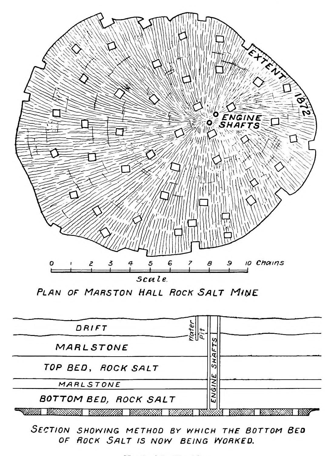
The roof gave trouble early. The Inspector of Mines, Joseph Dickinson, found in 1873 that the workings were six yards high with the rock salt of the roof 'not quite firm'; the pillars had been ten yards square and twenty-five yards apart, but the roof had cracked and the newer ones were being left twelve yards square and only eighteen apart. Further movement led to twenty timber cradles being built to hold the roof up, many of them along the line of the canal directly above.
The mine and its salt works were being run by the Marston Hall Salt Company Limited when they were sold to the Salt Union in 1888 for £25,182. The mine then covered 32 acres. The Salt Union went on working it, to about 40 acres, and in 1896 it was described as the largest mine in the trade.
It was last worked in 1905, when the roof fractured and water came in by a shaft. Two years later the flooded workings gave way beneath the canal (see Disasters, below). The abandoned mine was surveyed by William Bennett in 1908, by which time the pans and buildings had been dismantled and the whole property stood on sinking land. A further collapse followed in 1927.
Geology
The mine worked the bottom bed of rock salt, reached by its shafts at 315 feet. The workings were six yards high in 1873, and the roof of rock salt above them was not firm. An earlier mine in the upper bed of rock salt on the same site had been given up and its shaft used as a brine pit.
Geological setting: Evaporite Deposits (well documented example)
Workings
Pillar-and-stall workings in the bottom bed, reached by two shafts and an air shaft. In 1873 the pillars were 10 yards square and 25 yards apart, changed after the roof cracked to 12 yards square and 18 yards apart, and twenty timber cradles were later built under the roof. At the sale of 1888 the mine was 32 acres in extent and held two miles of rails, twenty trucks, an air-compressing machine, a drilling machine and a powder magazine, with winding engines, rock mills and a saw mill at the surface; it grew to about 40 acres by 1905. In 1881 the area on pillars was 28 acres and the workings 15 to 18 feet high. A modern table gives the final workings as 13.1 hectares at an average height of 5.8 metres. A salt works of twelve pans stood on the south-west side of the site, the mine buildings on the north-east, and a branch railway ran to the mine.
Closure
Last worked in 1905, when the roof fractured and a shaft flooded. The Salt Union's inventory of 1908 records the mine as flooded, the pans and buildings dismantled and the whole property on subsiding land. The abandonment plan is dated 1 May 1908. The 1907 collapse under the canal came after working had stopped, and a further collapse followed in 1927.
What remains
The site is private land and is still sinking. The ground where the salt works stood now lies about six metres below the level of the canal beside it, with open water at its centre, and the workings remain open underground. In 2015 the towpath here was below water level in places, held back by fresh concrete along its edge, and the canal had suffered collapses in the previous two years. The land has been used for off-road driving.
Earthworks around the remains of Forge Pool. A survey and excavation in 1993 found lines of brick foundations, an engine base of sandstone blocks and a well-preserved reservoir with earth banks. South-west of the pool a complex of earthworks 110 metres long and 60 wide, with three large square structures and seven smaller rectangular ones, proved to be the remains of pan houses and pan kilns.
Related mines
- Marston Pool Mine — Bought by the Salt Union in 1888 and inventoried in 1908 as one property; the Pool Mine was later pumped to hold back water from its flooded neighbours.
Nearby mines
- Marston Pool Mine — 0.2 miles (0.3 km) SE
- Marston Old Mine — 0.4 miles (0.7 km) SE
- Adelaide Mine — 0.6 miles (0.9 km) SE
- Crystal Mine, Marston — 0.6 miles (1.0 km) SE
- Lion Salt Works — 0.7 miles (1.1 km) SE
Straight-line distance, within 9 miles (15 km). Show on the map.
Disasters & major incidents
-
Marston Hall Mine canal burst, 1907
21 July 1907 · Collapse / Roof Fall · 0 fatalities
On Sunday 21 July 1907 the flooded workings of the Marston Hall rock-salt mine gave way beneath the Trent and Mersey Canal near Marston, Cheshire. The canal bank burst, a chasm some sixty feet across opened, and half a mile of canal emptied through it. Nobody is recorded as killed, and the breach was repaired in just over two weeks.
Recorded claims
Individual factual claims, each attached to the source(s) that support it below. Where sources disagree, both are kept.
- Sunk in 1850–51 by William Hayes, with two shafts and an air shaft all 315 feet to the bottom bed. 1
- Started in 1850 and abandoned in 1905, when the roof fractured and a shaft flooded. 2
- In 1873 the workings were 6 yards high with the roof not quite firm; pillars 10 yards square and 25 yards apart had been replaced, after the roof cracked, by pillars 12 yards square and 18 yards apart. 1
- In 1869 it was the first mine in the area to install a grinding mill. 1
- The mine and works, run as the Marston Hall Salt Company Ltd, were sold to the Salt Union in 1888 for £25,182, when the mine was 32 acres in extent. 1
- Worked by the Salt Union, it was the largest mine in the trade, with an excavated area of about 40 acres. 1,3
- The workings cover 13.1 hectares at an average height of 5.8 metres, and open workings remain. 2
- In 1881 the mine had a pair of shafts 315 feet deep and 28 acres of workings on pillars, 15 to 18 feet high. 4,5
- The mine was last worked in 1905 and was flooded by 1908, with the pans and buildings dismantled. 1,4
- The catalogued abandonment plan is dated 1 May 1908. 6
- The mine collapsed in 1907, breaching the Trent and Mersey Canal, and collapsed further in 1927. 1,2,7
- Survey and excavation in 1993 found brick foundations, a sandstone engine base, a reservoir and the remains of pan houses and pan kilns around Forge Pool. 1
Photographs & further reading
A 2011 photograph of a pool in farmland beside the canal, formed by subsidence over salt workings.
View sourceCouncil archaeological assessment of the Marston salt sites, with the history of the Marston Hall mine and works, the 1888 and 1908 inventories, a 1908 plan and a photograph of the 1907 breach.
View sourceThe Lion Salt Works museum's account of the morning in July 1907 when the mine's collapse emptied the Trent and Mersey Canal.
View sourceA 2012 paper on twenty years of surveying the sinking canal at Marston, with a table and plan of the seven rock-salt mines beside it.
View sourceSources
- (primary) Saltscape Project, Northwich, Cheshire: assessment of sites for archaeological fieldwork (Project A8, report 2015-001) — Cheshire West and Chester Council (Chris Hewitson)
- (secondary) Long-term time-lapse microgravity and geotechnical monitoring of relict salt mines, Marston, Cheshire, U.K. (Geophysics 77(6), B287-B294, 2012) — Pringle, Styles, Howell, Branston, Furner and Toon; Keele University repository
- (secondary) Marston, Great Budworth: Kelly's Directory of Cheshire (1896) — Forebears (transcription of Kelly's Directory of Cheshire, 1896)
- (secondary) The Great Canal Burst — Lion Salt Works, West Cheshire Museums
- (secondary) Salt in Cheshire (1915) — Albert F. Calvert (E. and F. N. Spon, London); Internet Archive
- (primary) Mine plan: MARSTON HALL, rock salt (feature 21862964) — British Geological Survey / Mining Remediation Authority mine plans catalogue
- (secondary) Northwich: The Town With That Sinking Feeling — TimeTravel-Britain
- (observational) Cheshire farm land near Higher Marston (photograph and description, 2011) — Geograph (Roger D Kidd)
Record created: 1 October 2026 · Last researched: 1 October 2026