 MineArchive
Marston Old Mine
| Also known as | Marston Mine, Marston Rockpits, Great Marston Mine, Marston Top, Bourne and Co.'s Mine, Fletcher and Rigby's Mine, Marston Old Salt Works |
|---|---|
| Location | Marston, near Northwich, Cheshire — 53.2778, -2.4995 (approximate) |
| Commodity | Salt |
| Type | Mineral |
| Worked | c. 1775 or 1777–By 1908 (worked out) |
| Maximum depth | 330 ft (110 yards) in 1881; also given as 120 yards |
| Operators | Gilbert and Bourne (1776–?), Worthington and Firth (1838–?), Fletcher and Rigby (?–1888), Salt Union Ltd (1888–1924) |
Overview
The earliest and longest-worked rock-salt mine at Marston, near Northwich, sunk about 1775 and from 1781 the first in the Northwich field to work the lower bed of rock salt. It was the celebrated show mine of the Cheshire salt district, lit with thousands of lamps for visitors recorded as including Emperor Nicholas I of Russia in 1844. Worked out by 1908 and abandoned in 1924, its collapsing ground forced the Trent and Mersey Canal onto a new line in 1958.
History
Marston Old Mine was the earliest and the longest-running rock-salt mine at Marston. A deed of 1776 records a salt works here that had been in the possession of Nicholas Ryder, and a fifty-year lease of salt works and brine springs from Thomas Lyons to Matthew Lyons, his son Thomas and John Gilbert, land agent to the Duke of Bridgewater and one of the promoters of the Trent and Mersey Canal, which opened past the site in 1777. Gilbert raised £1,000 from the Leicester family of Tabley Hall to develop the mine, and a map of 1786 marks it as Gilbert and Bourne's salt works. A guidebook of 1838 dated the first sinking to about sixty-three years earlier, which would be 1775.
The first workings were in the upper of two beds of rock salt. A lower bed had been found at Lawton in 1779, and in 1781 an experimental shaft was sunk through the upper bed at Marston to look for it, reaching the new bed at about 300 feet. It proved that the bottom bed ran under the Northwich field as well, and because its salt was much purer all mining moved down to it. Gilbert agreed to pay Boulton and Watt £50 a year for a licence to use a 10-horsepower steam engine for winding rock salt and pumping brine at 'Marston Rockpits'; it raised 9 hundredweight of salt at a time from 120 yards down. By 1795 the engine was in a bad state, its working gear audible almost a mile off, and Gilbert wanted it put in order because large orders for salt were expected once the wartime embargo on shipping at Liverpool was lifted.
By the 1830s the mine, then the property of Worthington and Firth, was the show place of the Cheshire salt field. The 1838 guide to the Grand Junction Railway found the shaft clean enough to go down without miner's clothing and said that 'princes and potentates of all nations' had descended, the Grand Duke Michael of Russia among them. When the British Association met at Liverpool, eighty of its members were entertained underground at a table set among 4,000 candles. The county directories record that in 1844 the Emperor Nicholas I of Russia visited the mine with the Royal Society, when it was lit with upwards of 10,000 lights and a banquet was served at the bottom, and that in 1854 members of the British Association came again and nearly a thousand people went down in a single day.
The tithe map of 1846 shows the works owned by Thomas Lyon and leased to Thomas Firth and Company as the Marston Salt Company. By the 1870s it was known as the Marston Old Salt Works or Marston Old Mine and was run by Fletcher and Rigby, who made white salt in open pans as well as raising rock salt. The mine and works were sold to the Salt Union on 19 July 1888 for £7,457 10s, though the conveyance was not completed until 1897, and the works were afterwards pulled down. The Salt Union's inventory of 1908 found the workings dry but the salt worked out to the old boundaries.
The old top-bed workings stayed intact, and were used for storing explosives, until 1921, when the roof cracked and water began to enter. The mine was abandoned in 1924. One of the shafts collapsed in 1933 and the hole went on growing however much was tipped into it. In 1953 a collapse of the ground over the mine breached the canal. By 1955 the crater threatened the Trent and Mersey Canal, and a new length of canal was dug round the sinking ground and opened in 1958.
Geology
Two beds of rock salt lie one above the other beneath Marston, both nearly horizontal. The mine began in the upper bed, about 60 yards down. The lower bed, proved here in 1781, lies some 50 yards deeper and gives a much purer salt, and it was the one worked from then on. The beds belong to the Triassic Northwich Halite. They lie beneath 8 to 25 metres of glacial drift and are separated by a band of sandstone and mudstone known locally as the Thirty-Foot Marl.
Geological setting: Evaporite Deposits (well documented example)
Workings
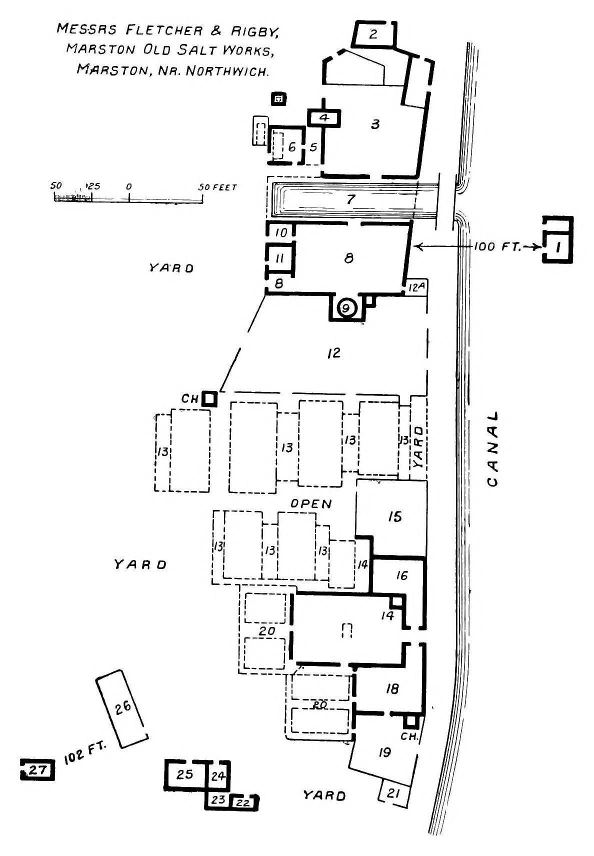
Pillar-and-stall workings in rock salt, entered in 1838 by three shafts, with another sunk inside the mine in search of a better bed. That year's guide describes pillars twelve to twenty yards across standing every twelve or fifteen yards, one to two hundred of them in about twelve acres of excavation. The excavated area is given as 33 acres in 1868, with pillars 16 feet high, and 35 acres in 1896; at its greatest the mine covered about 40 acres and reached 200 yards north of the canal and 300 yards south of it. A Boulton and Watt steam engine wound the salt and pumped brine. By the 1870s the surface carried eleven open salt pans, four storehouses and a canal basin. A modern table of the Marston mines gives the bottom-bed workings as 12.9 hectares with an average height of 4.9 metres, and the top-bed workings as 0.5 hectares, 9.1 metres high. In 1881 the bottom-bed mine was 330 feet deep and 15 to 16 feet high, its 40 acres carried on about 140 pillars. The old top-bed mine above it, about an acre and a quarter, stood on pillars some six yards by four; in 1897 they were found to be 30 to 35 feet high, under a roof worked with the pick so that it looked like a panelled ceiling.
Closure
The salt was worked out to the old boundaries by 1908, twenty years after the sale to the Salt Union. The disused top-bed workings were kept intact until water broke in through a cracked roof in 1921, and the mine was abandoned in 1924.
What remains
The ground over the mine is still sinking. The site lies in woodland on the south side of the Trent and Mersey Canal's new cut of 1958, on the line of the old canal, which survives as earthworks. In 2015 the nearest length of the new canal showed recent movement, with part of the towpath dipping to water level again, and a lake that had formed a few years earlier in the field opposite was growing. The workings remain open underground. Levelling of the canal bank from 1991 to 2011 found that the western and eastern margins of the old mine had sunk by about 0.3 to 0.6 metres, more than the ground over its centre, and the canal bank was built up with concrete in 1998, 2004, 2006 and 2008. Ten years of gravity surveys pointed to a void working its way upward near the mine's eastern margin, and drilling there confirmed one, 1 to 5 metres high and some 30 to 40 metres below ground.
No buildings stand. The works were pulled down after the Salt Union took possession in 1897; by 1908 the pans had been removed and what buildings remained were in ruins. An archaeological assessment of 1992 judged the site of the mine to have low archaeological potential.
Related mines
- Adelaide Mine — Neighbouring Marston rock-salt mines, both Salt Union property from 1888, whose sinking ground forced the Trent and Mersey Canal onto its new cut in 1958; the Old Mine's imperial visit of 1844 is often wrongly attached to the Adelaide.
- New Zealand Mine, Marston — Both were worked in the 1870s and 1880s by Fletcher and Rigby and sold to the Salt Union in July 1888.
Nearby mines
- Adelaide Mine — 0.2 miles (0.3 km) SE
- Crystal Mine, Marston — 0.2 miles (0.3 km) SE
- Marston Pool Mine — 0.2 miles (0.3 km) NW
- Lion Salt Works — 0.2 miles (0.4 km) SE
- New Zealand Mine, Marston — 0.3 miles (0.5 km) SE
Straight-line distance, within 9 miles (15 km). Show on the map.
What's uncertain
Points where sources disagree or the record could not be settled; both accounts are kept. All open questions in the archive.
- The Marston pit was first sunk about 1775. (disputed) 1
- The mine was first worked around 1777. (disputed) 2,3
- The top-bed mine was preserved intact until its roof cracked and water began to enter in 1921. (disputed) 1
- The top-bed mine was abandoned in 1920, flooded along with the bottom-bed mine. (disputed) 3
Recorded claims
Individual factual claims, each attached to the source(s) that support it below. Where sources disagree, both are kept.
- A salt works here was in the possession of Nicholas Ryder by a deed of 1776, when the salt works and brine springs were leased for fifty years to Matthew and Thomas Lyons and John Gilbert. 1
- The Marston pit was first sunk about 1775. (disputed) 1
- The mine was first worked around 1777. (disputed) 2,3
- A shaft sunk through the upper bed in 1781 proved the bottom bed of rock salt in the Northwich field, and all mining took place in the bottom bed afterwards. 1,4
- John Gilbert paid Boulton and Watt £50 a year for a licence to use a 10 hp steam engine for winding rock salt and pumping brine at 'Marston Rockpits'. 1,4
- The Grand Duke Michael of Russia went down the mine, and eighty members of the British Association were entertained in it by the light of 4,000 candles. 1
- In 1844 Emperor Nicholas I of Russia visited the mine with the Royal Society, when it was illuminated with upwards of 10,000 lights and a banquet was provided at the bottom. 1,5,6
- In 1854 members of the British Association visited the mine and nearly 1,000 people descended in one day. 5,6
- The mine is 120 yards deep with an excavated area of 35 acres. 5
- At its maximum the mine covered about 40 acres, extending 200 yards north of the canal and 300 yards south. 1
- The mine and works, owned by Thomas Henry Lyon and run by Fletcher and Rigby, were sold to the Salt Union on 19 July 1888 for £7,457 10s. 1
- The mine was abandoned in 1924, its shafts and workings flooded. 1,3
- A shaft collapsed in 1933, and a new length of the Trent and Mersey Canal bypassing the sinking ground was opened in 1958. 1,7,8
- John Gilbert raised £1,000 from the Leicester family of Tabley Hall to develop the Marston Mine, sinking a shaft from the top-bed mine to the bottom bed of rock salt at 300 feet. 1,4
- A surface collapse at the mine breached the Trent and Mersey Canal in 1953, which led to the canal being rerouted. 3
- The top-bed mine was preserved intact until its roof cracked and water began to enter in 1921. (disputed) 1
- The top-bed mine was abandoned in 1920, flooded along with the bottom-bed mine. (disputed) 3
- The bottom-bed workings cover 12.9 hectares at an average height of 4.9 metres and the top-bed workings 0.5 hectares at 9.1 metres; open workings remain. 3
- Two rock-salt beds of the Northwich Halite, separated by the Thirty-Foot Marl, lie under 8 to 25 metres of glacial drift. 3
- The western and eastern margins of the mine sank by about 0.3 to 0.6 metres between 1991 and 2011, and drilling confirmed a void 1 to 5 metres high at 30 to 40 metres depth beside it. 3
- In 1881 it was the oldest existing rock-salt mine in England and the first sunk to the lower bed: 330 feet deep, with 40 acres supported on about 140 pillars and workings 15 to 16 feet high. 9
- In June 1897 the Marston Old Top Mine was the only mine still working in the upper bed and was in very good condition, its pillars 30 to 35 feet high. 9
Photographs & further reading
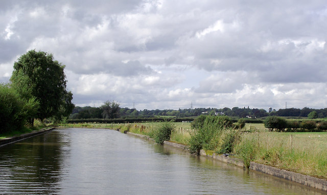
A 2011 photograph of the 1958 new cut, with a note on the old line of the canal beside it.
View sourceCouncil archaeological assessment of the Marston salt sites, with the history of the Marston Old Mine, an 1838 description of a descent and a sketch plan of about 1880.
View sourceThe 1896 directory entry for Marston, giving the mine's depth and area and the visits of 1844 and 1854.
View sourceThe Lion Salt Works museum's account of the canal collapses at Marston, including the 1958 diversion over the Marston Old and Adelaide mines.
View sourceA 2012 paper on twenty years of surveying the sinking canal at Marston, with a table and plan of the seven rock-salt mines beside it.
View sourceSources
- (primary) Saltscape Project, Northwich, Cheshire: assessment of sites for archaeological fieldwork (Project A8, report 2015-001) — Cheshire West and Chester Council (Chris Hewitson)
- (secondary) Marston, Cheshire — Wikipedia
- (secondary) Long-term time-lapse microgravity and geotechnical monitoring of relict salt mines, Marston, Cheshire, U.K. (Geophysics 77(6), B287-B294, 2012) — Pringle, Styles, Howell, Branston, Furner and Toon; Keele University repository
- (secondary) The Lion Salt Works, Northwich, Cheshire: the restoration of a Victorian salt works (Manchester Region History Review 15) — Andrew Fielding, Lion Salt Works Trust
- (secondary) Marston, Great Budworth: Kelly's Directory of Cheshire (1896) — Forebears (transcription of Kelly's Directory of Cheshire, 1896)
- (secondary) Great Budworth: The National Gazetteer of Great Britain and Ireland (1868) — GENUKI
- (secondary) The Great Canal Burst — Lion Salt Works, West Cheshire Museums
- (observational) Trent and Mersey Canal near Marston, Cheshire (photograph and description, 2011) — Geograph (Roger D Kidd)
- (secondary) Salt in Cheshire (1915) — Albert F. Calvert (E. and F. N. Spon, London); Internet Archive
Record created: 1 October 2026 · Last researched: 1 October 2026