 MineArchive
New Zealand Mine, Marston
| Also known as | Gregory's Mine, Marston Gregory's Mine, New Zealand Mine, New Zealand Salt Works, Greyacres, Ollershaw Lane Mine, Fletcher's Mine |
|---|---|
| Location | Marston, near Northwich, Cheshire — 53.2743, -2.4948 (approximate, low confidence) |
| Commodity | Salt |
| Type | Mineral |
| Worked | c. 1828–By 1908 (flooded) |
| Maximum depth | Unknown. |
| Operators | William Furnival (1828–1831), William Gregory (1833–?), Fletcher and Rigby (?–1888), Salt Union Ltd (1888–1920) |
Overview
A small rock-salt mine and salt works at Marston, near Northwich, begun about 1828 by William Furnival for his patent salt process and lost by him in a price war with the established proprietors. Reworked from 1869 as Fletcher and Rigby's New Zealand Salt Works, it was bought and dismantled by the Salt Union in 1888-89, was flooded by 1908 and had its shafts filled in 1920.
History
William Furnival, a salt maker who had patented a way of making more salt for less fuel, bought ground at Marston in about 1828 and began a works there, with brine and dry rock salt, as he said, on the same premises. The established proprietors would not have the competition. They combined against him, sold their salt at a loss and drove him out of business, and Furnival himself ended in Horsemonger Lane Gaol. He sold the mine on 1 September 1831, when it had 'two shafts into a mine and one brine shaft'. H. Back ran it until 1833 and William Gregory after him; the tithe map of 1846 shows it as Gregory's, and one account has the property worked until 1847.
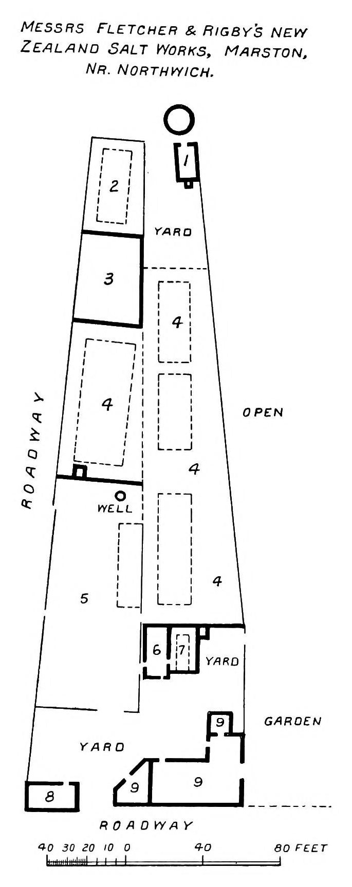
It was reopened, or reworked, in 1869, the year some accounts give for its beginning. It was a small mine of just over two acres and went by many names: Gregory's Mine, Greyacres, Fletcher's Mine, the Ollershaw Lane Mine. By the 1870s it was Fletcher and Rigby's New Zealand Salt Works, a triangular plot with five or six open pans and a storehouse, a gasometer at the north end, and the engine house, rock house and a dwelling at the south, facing the road now called The Avenue.
The Salt Union bought it from Johnson, Fletcher and Others on 21 July 1888 for £6,500 and dismantled the works the following year. By 1908 the mine was filled with brine, the rock house was in ruins and the engine house had gone. On 20 December 1920 the filling of the shafts began. It took only two canal-boat loads of concrete rubble and rubbish from the old rock-house foundations, and the work was finished on Christmas Eve.
Geology
The mine worked the bottom bed of rock salt, the lower of the two beds of the Northwich Halite beneath Marston, and the works also drew brine from a shaft of its own.
Geological setting: Evaporite Deposits (historical documentary reference)
Workings
A small mine of just over two acres, given in a modern table as 1.3 hectares, with two rock shafts and a brine shaft. In the 1870s the surface works had five or six open pans, a storehouse and two loading stages, with an engine house and rock house for the mine.
Closure
The Salt Union dismantled the salt works in 1889, the year after buying it. By 1908 the mine was filled with brine, and a modern table gives it as abandoned, flooded, in that year. The two rock shafts and the brine shaft were filled between 20 and 24 December 1920.
What remains
The shafts are filled and the workings remain open underground. In 2014 the site was part of a plot used as a scrap yard.
Related mines
- Crystal Mine, Marston — Sold to the Salt Union together in one lot on 21 July 1888; both had been Fletcher mines.
- Marston Old Mine — Both were worked in the 1870s and 1880s by Fletcher and Rigby and sold to the Salt Union in July 1888.
Nearby mines
- Lion Salt Works — 0.1 miles (0.1 km) N
- Crystal Mine, Marston — 0.1 miles (0.2 km) NW
- Adelaide Mine — 0.2 miles (0.3 km) N
- Marston Old Mine — 0.3 miles (0.5 km) NW
- Marston Pool Mine — 0.5 miles (0.8 km) NW
Straight-line distance, within 9 miles (15 km). Show on the map.
What's uncertain
Points where sources disagree or the record could not be settled; both accounts are kept. All open questions in the archive.
- It was reopened or reworked in 1869 and was a small mine of just over 2 acres. (disputed) 1
- Started in 1870 and abandoned, flooded, in 1908, with workings of 1.3 hectares; the shafts are filled but open workings remain. (disputed) 4
Recorded claims
Individual factual claims, each attached to the source(s) that support it below. Where sources disagree, both are kept.
- William Furnival bought the site in about 1828 for his patented salt process; a price war by the other salt manufacturers forced him out, and he sold the mine on 1 September 1831, when it had two shafts into a mine and one brine shaft. 1
- Furnival began works intended to occupy nearly six acres at Marston, with brine and dry rock salt on the same premises; the Marston property appears to have been worked until 1847. 2
- The Cheshire salt proprietors formed a coalition, lowered their prices and put Furnival out of business. 2,3
- The mine was run by H. Back until 1833 and then by William Gregory, to whom it belonged on the Marston tithe map of 1846. 1
- It was reopened or reworked in 1869 and was a small mine of just over 2 acres. (disputed) 1
- Started in 1870 and abandoned, flooded, in 1908, with workings of 1.3 hectares; the shafts are filled but open workings remain. (disputed) 4
- The Salt Union bought the mine from Johnson, Fletcher and Others on 21 July 1888 for £6,500 and dismantled the works in 1889. 1
- In 1908 the mine was filled with brine, the rock house in ruins and the engine house demolished. 1
- The two rock shafts and the brine shaft were filled between 20 and 24 December 1920 with two canal-boat loads of rubble. 1
- A sketch plan printed in 1915 shows Fletcher and Rigby's New Zealand Salt Works as a long tapering plot between two roadways, with open pans, a well and yards. 5
Photographs & further reading
Council archaeological assessment of the Marston salt sites, with the New Zealand works' history from Furnival onwards and a sketch plan of the 1870s.
View sourceA 2012 paper on twenty years of surveying the sinking canal at Marston, with a table and plan of the seven rock-salt mines beside it.
View sourceCalvert's account of William Furnival, his patent process, his works at Anderton, Wharton and Marston and the proprietors' campaign against him.
View sourceSources
- (primary) Saltscape Project, Northwich, Cheshire: assessment of sites for archaeological fieldwork (Project A8, report 2015-001) — Cheshire West and Chester Council (Chris Hewitson)
- (secondary) Salt and the Salt Industry (Pitman's Common Commodities and Industries) — Albert F. Calvert; Project Gutenberg
- (secondary) Salt, Salt Making, and the Rise of Cheshire (Transactions of the Newcomen Society 75, 2005) — L. Gittins; Newcomen Society
- (secondary) Long-term time-lapse microgravity and geotechnical monitoring of relict salt mines, Marston, Cheshire, U.K. (Geophysics 77(6), B287-B294, 2012) — Pringle, Styles, Howell, Branston, Furner and Toon; Keele University repository
- (secondary) Salt in Cheshire (1915) — Albert F. Calvert (E. and F. N. Spon, London); Internet Archive
Record created: 1 October 2026 · Last researched: 1 October 2026