 MineArchive
Glapwell Colliery
| Also known as | Glapwell Collieries, Glapwell No. 1 Colliery, Glapwell No. 3 Colliery |
|---|---|
| Location | Ault Hucknall, near Glapwell and Bolsover, Derbyshire — 53.1945, -1.3050 (approximate) |
| Commodity | Coal |
| Type | Coal |
| Worked | 11 August 1882–1974 |
| Maximum depth | About 680 yards. The shafts were first sunk to the Top Hard at roughly 300 yards, and sinking was continued at the No. 2 shaft to prove the lower seams to that depth by 1918. |
| Operators | Sheepbridge Coal and Iron Company (1882–1946), National Coal Board (1947–1974) |
Overview
One of the Sheepbridge Coal and Iron Company's new Top Hard collieries, sunk from 1882 on the Derbyshire concealed coalfield and worked until 1974. Despite the name it stands in Ault Hucknall; Glapwell was a village of eighteen houses when sinking began, and nearly five hundred were built over the pit's life, along with the planned colliery villages of Doe Lea and Bramley Vale. The shafts reached the Top Hard at about 300 yards and were later carried down to around 680 yards to prove the lower seams. With the Bramley Vale surface drifts of 1954 the complex raised a million tons a year, and employment peaked at about 3,000 in 1947.
History
The Sheepbridge Coal and Iron Company sank Glapwell in an era when the country wanted good coking and steam coal, and when the Top Hard, the Derbyshire and Nottinghamshire name for the Barnsley Bed, was the seam everyone wanted. Sinking began on 11 August 1882 and the Top Hard was reached in July 1883. The company took leases from the principal landowners: a sixty-year lease of 1,100 acres from the Reverend Hallowes of Glapwell Hall, and coal under the Arkwrights' land at Palterton from Sutton Scarsdale Hall.
The scheme was ambitious and nearly overreached. Sheepbridge developed Glapwell and Langwith alone while joining the Staveley company to open a new coalfield at Newstead, and the combined financial commitment forced the flotation of a new company merging Staveley and Sheepbridge interests, which relieved the strain and let Newstead proceed. An underground link from Glapwell to Langwith, some four and a half miles away, was planned.
For the first thirty years only the upper seams were taken. In 1916 the company leased the lower seams and gave the colliery a second life; sinking at the No. 2 shaft had already been carried down from the Top Hard to prove the lower reserves to about 680 yards by 1918, and a third shaft was sunk between 1920 and 1934. The extent of the workings can be judged from the fact that there are at least nine shafts and two or three drifts in the immediate area of the main site.
Employment grew almost continuously: 943 in 1894, 1,067 in 1900, 1,422 in 1910, 1,830 in 1923, 2,600 in 1933 and 3,000 in 1947, of whom 2,200 worked below ground. The colliery came through both wars and was vested in the National Coal Board in 1947. An experimental coking by-product plant built on Coalite lines in the late 1920s or early 1930s was a failure and was closed.
The last major investment came in 1954, when two surface drifts were driven into the Clowne seam at 1,140 yards on a gradient of 1 in 5. These Bramley Vale Drifts were incorporated into the Glapwell complex, and while both were working the combined output reached a million tons a year. The drifts closed in 1970 and Glapwell itself in 1974, its men transferred to other local collieries.
Geology
Glapwell worked the concealed part of the Derbyshire coalfield, where the Coal Measures dip east beneath the Permian Magnesian Limestone; the village sits on the western edge of that limestone, overlooking the Doe Lea valley. The seam that justified the sinking was the Top Hard, the local name for the Barnsley Bed, the thickest and most valuable coal of the district. Below it lay the reserves the company waited thirty years to lease: the Deep Hard, the Low Main (called the Glapwell seam here), the Blackshale, and in the upper measures the First Waterloo and Dunsil. The Clowne seam, worked from the Bramley Vale drifts, lies at a shallower horizon reached from the surface at 1,140 yards along a 1 in 5 gradient.
Geological setting: Concealed Coalfields (historical documentary reference), Sedimentary Beds and Seams (well documented example)
Workings
Two main shafts and, from 1954, the Bramley Vale surface drifts. The No. 2 shaft was the upcast, 306 yards deep and 14 feet in diameter as first sunk, deepened in 1924 to 669 yards and widened to 18 feet; a third shaft was sunk between 1920 and 1934 to about 657 yards. Work at the face was in stalls, with ripping in the gates, packs built in the waste and shot firing in the rippings, the ordinary method of the East Midlands Top Hard pits and the one that appears again and again in the accident reports. Miners knew one of the manriding shafts here as the Shonky shaft, a nickname it shared with shafts at Markham, Oxcroft and Ramcroft; a man who rode it in about 1956 recalled a kink below the Top Hard inset that made the cages rub the sides as a matter of course, and an occasion when a cage stuck fast at an angle until full winding power was applied to free it.
Closure
The Bramley Vale drifts closed in 1970, after which Glapwell produced about 400,000 tons of saleable coal a year against the million tons the two had raised together. The colliery closed in 1974 and its men were transferred to other local pits. Sources differ on the exact day, one giving 28 June 1974 and another 30 June 1974; neither was confirmed from a document here. The No. 1 pit had already been abandoned on 19 August 1960.
What remains
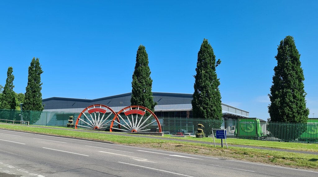
The colliery site and that of the neighbouring Bramley Vale drift mine have been cleared and redeveloped as an industrial estate. Winding wheels have been preserved and set up as memorials to the two mines, photographed on Geograph in 2024, and a separate memorial records the miners lost at Bramley Vale Drift Mine and Glapwell Colliery.
Nothing of the working colliery stands. What survives is commemorative: the preserved winding wheels and the memorial to the men killed at Glapwell and at Bramley Vale, on the regenerated site beside the A617 at Bramley Vale and Doe Lea.
Redevelopment
The site of the Glapwell and Bramley Vale collieries is now an industrial estate. The planned company villages remain: Doe Lea and Bramley Vale were laid out as the colliery was being sunk, with mains water, rail services, a post office, a public house, a Miners' Welfare, a school and shops, and houses were added in stages as the pit grew. The colliery made its own town gas, which was piped to the houses.
Related mines
- Tibshelf Colliery — Most of the Tibshelf men went to Glapwell when the Top Pits closed in 1939.
Nearby mines
- Ramcroft Colliery — 0.7 miles (1.2 km) NW
- Holmewood Colliery — 1.9 miles (3.1 km) W
- Williamthorpe Colliery — 2.3 miles (3.7 km) W
- Bolsover Colliery — 2.3 miles (3.8 km) N
- Pleasley Colliery — 2.5 miles (4.0 km) SE
Straight-line distance, within 9 miles (15 km). Show on the map.
Disasters & major incidents
-
Glapwell Colliery Roof Fall
17 December 1909 · Collapse / Roof Fall · 2 fatalities
On 17 December 1909 a deputy and a ripping contractor were killed instantly by a fall of stone in the Top Hard seam at Glapwell Colliery, in Derbyshire.
Culture
- Dennis Skinner at Parkhouse and Glapwell Collieries (Labour)
Dennis Skinner worked at Glapwell Colliery near Bolsover from 1962, after Parkhouse closed, until he entered Parliament in 1970.
What's uncertain
Points where sources disagree or the record could not be settled; both accounts are kept. All open questions in the archive.
- The No. 2 shaft was the upcast, 306 yards deep and 14 feet in diameter as sunk, deepened in 1924 to 669 yards and 18 feet; a third shaft was sunk between 1920 and 1934 to about 657 yards. These figures sit slightly awkwardly with the same source's statement that 680 yards had been proved by 1918. (uncertain) 1
Recorded claims
Individual factual claims, each attached to the source(s) that support it below. Where sources disagree, both are kept.
- Sinking began on 11 August 1882 and the Top Hard, or Barnsley Bed, was reached in July 1883. The shafts were first taken to about 300 yards, and sinking was continued at the No. 2 shaft to prove the lower seams to about 680 yards by 1918. 1
- Government Lists of Mines record 943 employed in 1894, 1,067 in 1900, 1,422 in 1910, 1,830 in 1923, 2,600 in 1933 and 3,000 in 1947, of whom 2,200 were below ground. 2
- The Sheepbridge company took a sixty-year lease of 1,100 acres from the Reverend Hallowes of Glapwell Hall, and coal under the Arkwrights' land at Palterton from Sutton Scarsdale Hall. 1
- Two surface drifts were driven into the Clowne seam at 1,140 yards on a 1 in 5 gradient in 1954 and incorporated into the Glapwell complex. While both were working the two pits produced a million tons a year; the drifts closed in 1970 and output fell to about 400,000 tons of saleable coal a year. 1
- The No. 2 shaft was the upcast, 306 yards deep and 14 feet in diameter as sunk, deepened in 1924 to 669 yards and 18 feet; a third shaft was sunk between 1920 and 1934 to about 657 yards. These figures sit slightly awkwardly with the same source's statement that 680 yards had been proved by 1918. (uncertain) 1
- One of the manriding shafts at Glapwell was known to miners as the Shonky shaft, a name also used at Markham, Oxcroft and Ramcroft. A former roadlayer recalled a kink below the Top Hard inset that made the cages rub the shaft sides, and a cage sticking fast at an angle in about 1956 until full winding power freed it. 3
- The BGS mine-plans catalogue holds a Mining Remediation Authority abandonment plan titled 'Glapwell' (catalogue EMST2, Spoil Tip, dated 1976). 4
Photographs & further reading
The fullest account located: sinking dates, shaft depths and diameters, the Hallowes and Arkwright leases, Sheepbridge's simultaneous development of Langwith and Newstead and the financial strain it caused, the 1916 leasing of the lower seams, the failed Coalite-style coking plant, the Bramley Vale drifts of 1954, and the building of the Doe Lea and Bramley Vale colliery villages.
View sourceOwners, output and employment by List of Mines year from 1894 to 1950, the seams worked, and a long roll of men killed at the colliery, many with the Inspector of Mines' account of the accident and many more listed from the colliery memorial.
View sourceA discussion of the nickname 'Shonky' given to manriding shafts at Glapwell, Markham, Oxcroft and Ramcroft, built around a former miner's first-hand account of a cage jamming in the Glapwell shaft in about 1956.
View sourceA 2024 photograph of the preserved winding wheels standing as memorials on the regenerated colliery site, captioned with the colliery's sinking and closure dates.
View sourceSources
- (secondary) Glapwell Collieries 1882-1974 — oldminer.co.uk
- (primary) Glapwell Colliery — Durham Mining Museum
- (observational) The Glapwell Shaft — oldminer.co.uk
- (primary) BGS / Mining Remediation Authority mine plans: GLAPWELL — British Geological Survey / Mining Remediation Authority
Record created: 10 September 2026 · Last researched: 10 September 2026