 MineArchive
Crigglestone Colliery
| Location | Crigglestone, near Wakefield, West Yorkshire — 53.6409, -1.5258 (exact) |
|---|---|
| Commodity | Coal |
| Type | Coal |
| Worked | from 1889 |
| Maximum depth | Unknown. |
| Operators | Benzol and By-Products Ltd (?–1947), National Coal Board (1947–?) |
Overview
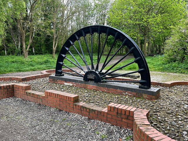
Crigglestone Colliery was sunk from 1889 three miles south-south-west of Wakefield and became one of the larger West Riding pits, employing 1,334 people through the 1920s and 1930s and raising 380,000 tons of coking and household coal for the National Coal Board in 1947. Its Dirtcar Pit stood a little to the north-east. It worked the Lidgett and the Low and Top Haigh Moor seams. Its owner before nationalisation was Benzol and By-Products Ltd, a name that says what the coking coal was for. The site is now Betty Eastwood Park, with a winding wheel and a miners' memorial in it.
History
Sinking at Crigglestone started in 1889. By the 1920s it was a large colliery: the Lists of Mines return 1,334 people in both 1923 and 1933, 977 of them below ground, and 1,020 in 1937, 1940 and 1947. Benzol and By-Products Ltd held it before nationalisation — a company named for the chemical products recovered from coking coal, which is what Crigglestone raised. In 1947 the colliery produced 380,000 tons of coking and household coal for the National Coal Board, and in 1954 it employed 967 people working the Lidgett, Low Haigh Moor and Top Haigh Moor seams. A second shaft, the Dirtcar Pit, stood about half a mile to the north-east.
Geology
Crigglestone worked the Lidgett and the Low and Top Haigh Moor seams of the Yorkshire Coal Measures south of Wakefield. The Haigh Moor is one of the West Riding's principal coking coals, which is why the colliery's output went to a benzol and by-products company.
Geological setting: Sedimentary Beds and Seams (well documented example)
Workings
The main colliery three miles south-south-west of Wakefield with the Dirtcar Pit about half a mile to the north-east, served by its own railway. The Coal Authority holds a catalogue of plans of abandoned mines for Crigglestone Colliery.
Closure
The closure date is not known. The colliery was still employing 967 people in 1954. Its ground is now Betty Eastwood Park at Crigglestone, where a winding wheel and a miners' memorial stand, and the former railway cutting that served the pit runs wooded through the park.
What remains
The colliery site is Betty Eastwood Park, a public park at Crigglestone with woodland paths, a pond and a BMX track. A colliery winding wheel is displayed there and a miners' memorial stands beside the paths; the wooded cutting of the colliery railway runs through the park.
The site is Betty Eastwood Park; a colliery winding wheel is displayed there and the wooded cutting of the colliery railway runs through the park.
Nearby mines
- Newmillerdam Colliery — 0.8 miles (1.2 km) E
- Bullcliffe Wood Colliery — 2.0 miles (3.2 km) SW
- Walton Colliery — 2.4 miles (3.9 km) E
- Hostingley Colliery — 3.1 miles (4.9 km) NW
- Woolley Colliery — 3.2 miles (5.1 km) S, South Yorkshire
Straight-line distance, within 9 miles (15 km). Show on the map.
Disasters & major incidents
-
Crigglestone Colliery explosion, 1941
29 July 1941 · Explosion · 22 fatalities
An explosion of firedamp in No. 1 West District of the Top Haigh Moor seam at Crigglestone Colliery, near Wakefield, on the evening of 29 July 1941 killed 22 men. The Inspector concluded that firedamp in a break had been ignited by a ripping shot fired two and a half hours earlier and burned unseen until it met an explosive mixture.
What's uncertain
Points where sources disagree or the record could not be settled; both accounts are kept. All open questions in the archive.
- The BGS mine-plans catalogue holds a Mining Remediation Authority abandonment plan titled 'Crigglestone' (catalogue NE656, Low Haigh Moor, dated 1969); the catalogue gives no location and the plan's details do not clearly tie it to this working, so it may belong to another of the same name. (uncertain) 2
Recorded claims
Individual factual claims, each attached to the source(s) that support it below. Where sources disagree, both are kept.
- Sinking at Crigglestone Colliery started in 1889. 1
- The colliery employed 1,334 people in 1923 and 1933, 1,020 in 1947 and 967 in 1954. 1
- Benzol and By-Products Ltd held the colliery before nationalisation; in 1947 it raised 380,000 tons of coking and household coal. 1
- The Lidgett, Low Haigh Moor and Top Haigh Moor seams were being worked in 1954. 1
- The Dirtcar Pit stood about half a mile north-east of the main colliery. 1
- The BGS mine-plans catalogue holds a Mining Remediation Authority abandonment plan titled 'Crigglestone' (catalogue NE656, Low Haigh Moor, dated 1969); the catalogue gives no location and the plan's details do not clearly tie it to this working, so it may belong to another of the same name. (uncertain) 2
Photographs & further reading
The 1889 sinking, the Dirtcar Pit, owners, output, employment and seams for each Lists of Mines year, and a link to the catalogue of abandonment plans.
View sourceThe village the colliery served, south-west of Wakefield.
View sourceSources
- (primary) Durham Mining Museum: Crigglestone Colliery — Durham Mining Museum, from the Lists of Mines
- (primary) BGS / Mining Remediation Authority mine plans: CRIGGLESTONE — British Geological Survey / Mining Remediation Authority
- (observational) Winding wheel in Betty Eastwood Park, Crigglestone (photographed 2024) — Geograph Britain and Ireland, Graham Hogg
- (secondary) Crigglestone — Wikipedia
Record created: 10 September 2026 · Last researched: 10 September 2026