 MineArchive
Conistone Moor Mines
| Location | Conistone Moor, between Conistone Moorhead and Mossdale, upper Wharfedale, North Yorkshire — 54.1119, -1.9915 (approximate) |
|---|---|
| Commodity | Lead |
| Type | Metal |
| Worked | 18th century–1872 |
| Maximum depth | Unknown. |
| Operators | Conistone Moorhead Mining Company (1862–1868), North Mossdale Mining Company |
Overview
The lead mines of Conistone Moor in upper Wharfedale, a belt of veins two miles long from Conistone Moorhead to Mossdale, worked by shallow shafts from the eighteenth century and by small companies in the mid-1800s until the last deep shafts stopped in 1872.
History
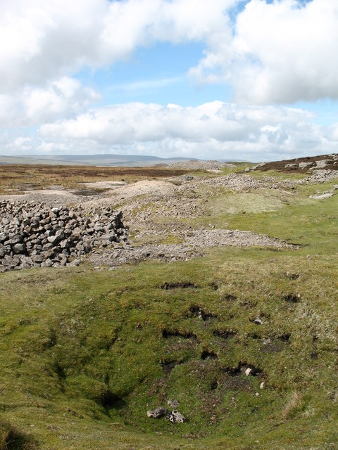
A belt of lead veins about two miles long runs from west to east across Conistone Moor, between Conistone Moorhead and Mossdale, above the village of Conistone in upper Wharfedale. West of Mossdale Beck their outcrops are marked by lines of shallow shafts, with the odd much deeper one; a line of shallow shafts along the South Cocklake Vein is among the most visible traces. Such closely spaced shafts belong to the meer system of the eighteenth century and earlier, under which miners took set lengths of a vein; one line near Seeds Hill is recorded as worked in the 1700s and again in 1828.
The Mossdale veins, in the Grassington Grit and the limestone beneath, were worked in the eighteenth century, and in the 1850s the North Mossdale Mining Company sank deeper shafts, raising about 300 tons of ore in nineteen years. Around 1862 the Conistone Moorhead Mining Company drove a level onto the Moorhead veins; despite optimistic claims in the press it produced very little ore and closed in 1868. The Out Moor mines were last worked from two deep shafts, Fearnought and Dreadnought, drained by a level driven north from Mossdale Beck, and that work ended in 1872. A survey of Kelber, on the moor, in 2013 recorded lead workings, trial shafts and quarries among nineteen features.
Geology
Lead veins of the Grassington area, worked in the Grassington Grit and the underlying limestone; the Moorhead, Mossdale and Cocklake veins.
Workings
Lines of shallow shafts along the veins, a few deeper shafts including Fearnought and Dreadnought, a level onto the Moorhead veins (c. 1862) and a drainage level from Mossdale Beck.
Closure
The Moorhead level closed in 1868 and the Out Moor shafts stopped in 1872.
What remains
Open moorland managed for peat restoration, with the shaft lines and spoil surviving as earthworks.
Lines of filled and open shallow shafts with spoil mounds, isolated trial shaft mounds and old quarries.
Nearby mines
- Frankland Fold Mine — 1.3 miles (2.0 km) SE
- Grassington Moor Mines — 1.5 miles (2.5 km) SE
- Beever Mine — 2.1 miles (3.4 km) S
- Hebden Mines — 2.5 miles (4.0 km) SE
- Red Scar Mine — 3.3 miles (5.2 km) E
Straight-line distance, within 9 miles (15 km). Show on the map.
Recorded claims
Individual factual claims, each attached to the source(s) that support it below. Where sources disagree, both are kept.
- A belt of lead veins about two miles long runs across Conistone Moor between Conistone Moorhead and Mossdale. 1
- The Conistone Moorhead Mining Company drove a level onto the Moorhead veins around 1862; it produced very little ore and closed in 1868. 1
- The Out Moor mines were last worked from the Fearnought and Dreadnought shafts until 1872. 1
- The North Mossdale Mining Company raised about 300 tons of ore in nineteen years from shafts sunk in the 1850s. 1
- A line of lead shafts near Seeds Hill on Conistone Moor was worked in the 1700s and again in 1828. 2
- A line of shallow shafts follows the South Cocklake Vein on Conistone Moor. 3
Photographs & further reading
Oxford Archaeology North's survey of lead workings and other features on part of the moor.
View sourceSources
- (secondary) Conistone Moor (NMRS Mid-Pennine metal mines) — Northern Mine Research Society
- (secondary) Kelber, Conistone with Kilnsey, North Yorkshire: Archaeological Survey Report (Oxford Archaeology North, 2013) — Archaeology Data Service (Oxford Archaeology North)
- (secondary) Lead and Coal Mining in Upper Wharfedale (Upper Wharfedale Heritage Group) — Upper Wharfedale Heritage Group
Record created: 24 October 2026 · Last researched: 24 October 2026