 MineArchive
Cligga Head
| Location | Perranporth, Cornwall — 50.3381, -5.1806 (approximate) |
|---|---|
| Commodities | Tin, Arsenic, Copper, Silver, Tungsten |
| Type | Metal |
| Worked | pre-1825–1945 |
| Maximum depth | contact shaft deepened to 550 ft (168 m) during 1960s rehabilitation |
| Operators | Cligga Wolfram and Tin Mines Ltd (1938–1939), Rhodesian Mines Trust Ltd (1939–1945) |
Overview
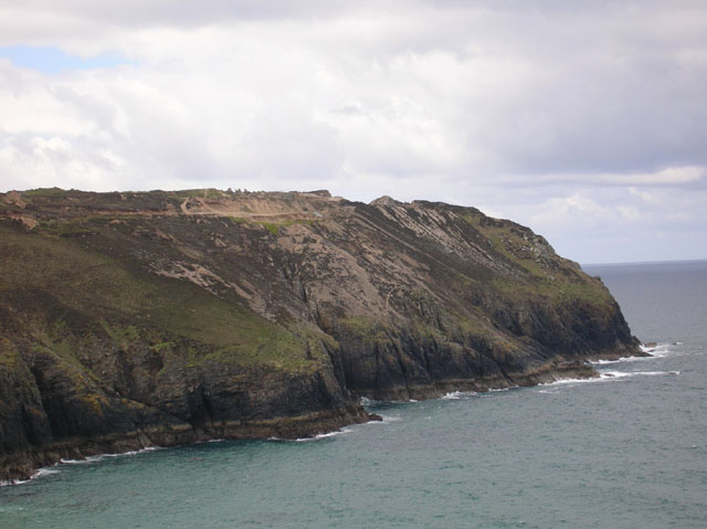
Cligga Head is a dramatic clifftop mine site near Perranporth, worked first for tin and then, most notably, for wartime tungsten. Its rich wolfram veins made it strategically important during the Second World War, and its collapsing adits and mineral-stained cliffs remain a landmark for geologists as much as mining historians.
History
Undocumented cliff workings extracted tin here before 1825, and the site operated through the 19th century as Wheal Prudence, an open tin mine. Its real significance came later: on 21 September 1938 the Cligga Wolfram and Tin Mines Ltd was founded to exploit the site's rich wolfram (tungsten) veins, and the mine passed to the Rhodesian Mines Trust Ltd in 1939. Wartime demand made this valuable — tungsten was needed for armour plating and munitions — and between 1940 and 1944 the mine produced around 300 tons of wolframite and 200 tons of black tin. Production fell away once Britain began importing cheaper American tungsten, and the mine closed in 1945.
Substantial mineral reserves are believed to remain beneath the headland, and reopening was seriously considered on three separate occasions in the 1960s, 1970s and 1980s. The Geevor Mining Company, in partnership with several other companies, leased the site in the early 1960s and deepened the contact shaft during rehabilitation work, but abandoned the attempt by early 1964 after flooding at around 250 ft. A further evaluation by Wheal Concord in 1976 planned a reopening for the mid-1980s that never proceeded.
Geology
The site is geologically notable for its greisen — a mineralised, altered granite — cut by a number of mineral lodes carrying ores of tin, tungsten, arsenic, copper, iron and silver. The cliff face is stained where the fissures and adits that drained the workings to sea level break out of it.
Geological setting: Greisen and Pegmatite Deposits (well documented example), Veins and Lodes (well documented example)
Workings
Ore was initially hauled up cliff workings in baskets before more conventional shaft mining developed. The wartime mine was worked on levels at 100, 200 and 300 ft, each with main drives east and west and numbered crosscuts running off them, as recorded in the surviving BGS plans. The contact shaft was deepened to 550 ft during the 1960s rehabilitation attempt, with a seaward drive extending roughly 800 ft under the sea.
Closure
The mine closed in 1945 once wartime demand for tungsten ended and cheaper American imports undercut domestic production. It was reopened between 1962 and 1965, and further attempts at revival in the 1970s and 1980s came to nothing once the tin price collapsed in 1985.
What remains
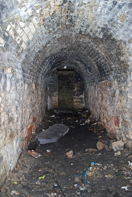
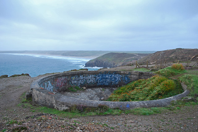
Extensive mine spoil remains visible near Shag Rock, and cliff collapses — some caused by vibration from historic blasting — have damaged earlier mine structures including a pump chamber. Tunnels and adits remain visible in the cliff face, which is constantly receding. A 2024 account of a guided descent made in 2010 describes ladders and tight passages underground and a surviving Cousin Jack chute, alongside extensive surface remains of open works, buildings, shafts and spoil tips. The headland still draws geologists: the Royal Geological Society of Cornwall ran a field trip here in August 2023.
Mine spoil and cliff-face tunnels are the main visible remains; there has been no formal conservation programme at the site.
Redevelopment
No redevelopment has taken place; substantial mineral reserves are believed to remain under the headland but no active mining has resumed.
Nearby mines
- Penhalls Mine — 1.8 miles (2.8 km) SW
- Wheal Friendly — 1.8 miles (2.9 km) SW
- Wheal Kine — 1.8 miles (2.9 km) SW
- Trevaunance Mine — 1.9 miles (3.0 km) SW
- Turnavore Mine — 1.9 miles (3.0 km) SW
Straight-line distance, within 9 miles (15 km). Show on the map.
What's uncertain
Points where sources disagree or the record could not be settled; both accounts are kept. All open questions in the archive.
- A 2019 underground exploration report describes a recent collapse in the giant stope at Cligga Head and unstable ground in places, with a short modern ladder used to pass between the stope and the middle level. (uncertain) 2
- An account published in 2024 of a guided descent made in August 2010 describes ladders and tight passages, a surviving Cousin Jack chute, and mineral staining across the cliff face where the fissures and adits that drained the mine to sea level break out; extensive remains of open works, buildings, shafts and spoil tips survive on the headland. (uncertain) 4
- After the 1945 closure the mine was reopened between 1962 and 1965, and further attempts at revival came to nothing once the tin price collapsed in 1985. (uncertain) 4
Recorded claims
Individual factual claims, each attached to the source(s) that support it below. Where sources disagree, both are kept.
- Between 1940 and 1944 the mine produced around 300 tons of wolframite and 200 tons of black tin, mainly for wartime munitions use. 1
- A 2019 underground exploration report describes a recent collapse in the giant stope at Cligga Head and unstable ground in places, with a short modern ladder used to pass between the stope and the middle level. (uncertain) 2
- The BGS holds ten Cligga Head Mine plans, catalogued MP24050 to MP24059, covering the 100, 200 and 300 ft levels — the main drives east and west and the numbered crosscuts off them — with scans publicly available. They are the clearest surviving record of how the wartime mine was laid out. 3
- An account published in 2024 of a guided descent made in August 2010 describes ladders and tight passages, a surviving Cousin Jack chute, and mineral staining across the cliff face where the fissures and adits that drained the mine to sea level break out; extensive remains of open works, buildings, shafts and spoil tips survive on the headland. (uncertain) 4
- After the 1945 closure the mine was reopened between 1962 and 1965, and further attempts at revival came to nothing once the tin price collapsed in 1985. (uncertain) 4
Photographs & further reading
A detailed geological and mining report on the site by the county's geological society.
View sourceFurther freely-licensed photographs of Cligga Head and the surrounding coastline.
View sourceAn August 2019 underground report covering the giant stope and the middle level (200ft), including the contact shaft that runs through all four levels and an ore chute bearing explorers' names dating back to around 1995.
View sourceSources
- (secondary) Cligga Head Mine, Cornwall — Cornwall Calling
- (observational) Cligga Head Mine: Giant Stope and Middle Level — 28DaysLater
- (primary) Cligga Head Mine level and crosscut plans (BGS catalogue MP24050-MP24059) — British Geological Survey
- (observational) Down Cligga — Cornish Story
- (secondary) Cligga Head Mine - Cornish Mine Images — Cornish Mine Images
Record created: 19 August 2026 · Last researched: 28 August 2026