 MineArchive
West Rigg Opencast
| Also known as | West Rigg Mine, West Rigg Open Cutting, West Rigg Open Cut, West Rigg Opencut |
|---|---|
| Location | Middlehope, near Westgate, County Durham — 54.7280, -2.1670 (approximate) |
| Commodities | Iron, Lead |
| Type | Iron |
| Worked | Late 19th century–1968 |
| Maximum depth | Unknown. The site is an opencast working rather than a deep shaft mine. |
Overview
A disused ironstone quarry in Weardale exposing the Slitt Vein of the North Pennine Orefield, worked first underground for fluorite and galena and later, from the late 19th century, as an opencast ironstone quarry that left the vein itself standing untouched as a rib down the centre of the cutting -- now protected as a Site of Special Scientific Interest.
History
The earliest mining activity at West Rigg was the underground extraction of fluorite and galena from the Slitt Vein itself, worked from levels driven into the vein from the west. The Slitt Vein is a 20-kilometre-long quartz intrusion running through the North Pennine Orefield, containing quartz with smaller amounts of fluorite and uneconomic amounts of galena lead ore. In the late 19th century, opencast quarrying of the ironstone deposits either side of the vein began; large deposits at the Rigg and West Rigg workings in Weardale supplied ironworks in Weardale itself and at Consett, Tow Law and Spennymoor. During the Late Permian period, iron-rich fluids had mineralised the surrounding Great Limestone, producing siderite and ankerite that oxidised into a limonitic ore running to over 40 per cent iron content, extending roughly 60 metres either side of the vein. The ironstone quarrying deliberately left the Slitt Vein itself untouched, so that it now protrudes as a vertical rib along the centre of the quarry. The site was designated a Site of Special Scientific Interest in 1968, covering 4.8 hectares, recognised by the Geological Conservation Review as nationally important for demonstrating iron ore formation by replacement and oxidation and for providing a rare surface exposure of the Slitt Vein.
Geology
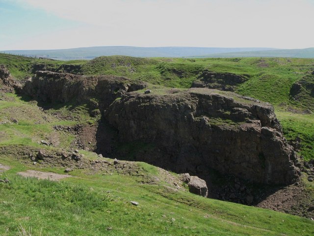
The Slitt Vein of the North Pennine Orefield, exposed in the quarry: worked first underground for fluorite and galena, then opencast for the ironstone in the same vein.
Workings
Underground levels driven into the Slitt Vein from the west for fluorite and galena, followed by later opencast quarrying of the surrounding ironstone that left the vein itself standing as an untouched rib through the centre of the cutting.
Closure
Unknown.
What remains
A disused ironstone quarry and Site of Special Scientific Interest (designated 1968, 4.8 hectares), with the Slitt Vein exposed as a vertical rib along the quarry's centre.
The opencast quarry itself, with the untouched Slitt Vein exposed as a vertical rib along its centre; associated spoil heaps survive nearby.
Nearby mines
- Greenlaws Mine — 0.2 miles (0.4 km) W
- Slitt Mine — 1.6 miles (2.5 km) NE
- Blackdene Mine — 1.9 miles (3.1 km) NW
- Heights Pasture Mine — 2.1 miles (3.4 km) NE
- Brandon Walls Mine — 2.6 miles (4.3 km) NE
Straight-line distance, within 9 miles (15 km). Show on the map.
Recorded claims
Individual factual claims, each attached to the source(s) that support it below. Where sources disagree, both are kept.
- The earliest mining activity at West Rigg was underground extraction of fluorite and galena from the Slitt Vein, a 20-kilometre-long quartz intrusion, worked from levels driven in from the west. 1
- Opencast ironstone quarrying began in the late 19th century, supplying ironworks in Weardale and at Consett, Tow Law and Spennymoor, and deliberately left the Slitt Vein itself untouched as a vertical rib along the quarry's centre. 2,1
- West Rigg was designated a Site of Special Scientific Interest in 1968, covering 4.8 hectares, recognised as nationally important for demonstrating iron ore formation by replacement and oxidation and for its rare surface exposure of the Slitt Vein. 1
Photographs & further reading
A fuller account of the site's SSSI designation, geology and the Slitt Vein exposure that makes it nationally important.
View sourceSources
- (secondary) West Rigg Open Cutting — Wikipedia
- (primary) Metalliferous and associated minerals, geology and man, Northern England — British Geological Survey (Earthwise)
Record created: 30 August 2026 · Last researched: 30 August 2026