 MineArchive
Slitt Mine
| Location | Slitt Wood, near Westgate-in-Weardale, County Durham — 54.7472, -2.1469 (approximate) |
|---|---|
| Commodity | Lead |
| Type | Metal |
| Worked | Early 1700s–1878 |
| Maximum depth | Seventy Fathom Level (c. 128m below adit) |
| Operators | W. B. Beaumont, Weardale Lead Mining Company Ltd |
Overview
A substantial lead mine on the Slitt Vein above Middlehope Burn, near Westgate-in-Weardale, worked under the Blackett and later Beaumont lead-mining interest and, by the 1880s-90s, the Weardale Lead Mining Company. It employed around 110 people at its recorded 1894 peak, driving named levels including the Seventy Fathom Level into the Three Yard Limestone. Its surface remains — shafts, wheel pits, a bouse team and the reservoir that fed its waterwheel — are unusually well preserved: the Low Slitt area was scheduled as a nationally important monument in 1997, and the wider Slitt Wood site is a Site of Special Scientific Interest.
History
Lead working in the Middlehope Burn valley is attested from around the 16th century, with large-scale working beginning in the early 1700s under the Blackett family's lead-mining interest, later continued by the Beaumont family. Government Mines Inspectors' Reports and mineral statistics, transcribed by the Durham Mining Museum, record W. B. Beaumont and the Weardale Lead Mining Company Ltd as the mine's owners through the 1880s, with lead ore output recorded in 1882, 1883, 1884, 1888, 1890 and 1894, and a workforce of 110 (60 underground, 50 on the surface) recorded in 1894.
A separate local-history account states the mine closed in 1878, largely as a result of competition from cheaper imported lead, having produced some 100,000 tons of lead ore over its working life with a peak workforce of over 100 men. This sits awkwardly against the primary-sourced government figures showing production and full employment as late as 1894, sixteen years after that stated closure date; the two accounts are recorded here as separate, unreconciled claims — the 1878 date may describe the closure of an earlier working phase rather than the site as a whole. Ore was carried by pack pony to Rookhope for smelting, each animal loaded with around two hundredweight, with the refined lead ingots then sent on to Blaydon.
Surviving extracts from the mine's own account books, covering 1853 to 1855, record piecework 'bargains' let to named working parties — among them Emerson Coulthard's six-partner team, Ralph Moses's team and Stephen Freak's team — contracting to drive or rise specific levels at rates such as 160 shillings per fathom and 35 shillings per bing, and confirm the mine operated on the standard Pennine bargain system, driving 'in the vein in the Three Yards Limestone.'
Geology
The Slitt and Red Veins are hosted within the Carboniferous limestone-shale-sandstone sequence of the North Pennine Orefield, with workings recorded specifically in relation to the Three Yard Limestone and extending toward the Whin Sill dolerite intrusion below the Tynebottom Limestone — the same basinal-brine, non-magmatic style of lead-zinc mineralisation typical of the wider Weardale district.
Workings
Workings followed the Slitt Vein, with the closely associated Red Vein also recorded on surviving mine plans, cutting the Alston Block sequence of the North Pennine Orefield. Named levels recorded in the mine's own 1853-55 account books include Kirks Level, Spring Bank Level and the Seventy Fathom Level, worked in the Three Yard Limestone; a main Engine Shaft served the workings. The mine comprised at least two named areas, referred to separately as 'Heights' (or High) Slitt and 'Low Slitt', reflected in a combined BGS mine plan covering both. A large waterwheel, fed by a purpose-built reservoir on the hillside above the site, drove the mine's machinery; massive sandstone blocks that anchored the wheel and pumping engines survive on site.
Closure
A local-history account states the mine closed in 1878, largely through competition from cheaper imported lead.
What remains
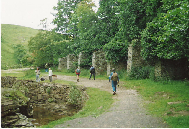
Old shafts, brickwork and wheel pits survive along the Slitt Wood trail running north from Westgate along Middlehope Burn, together with the reservoir that fed the mine's waterwheel and a surviving bouse team — stone-walled ore bins with an overhead tramway, comparable to a coal staithe. The site is promoted today as part of the signposted Slitt Wood and West Rigg Geotrail.
The Low Slitt area of the site was scheduled as a nationally important monument in 1997, with a landowner, Natural England and English Heritage conservation partnership formed in 2008 to manage the surviving remains. The wider 14.1-hectare Slit Woods site was separately designated a Site of Special Scientific Interest in 1976, valued in part because revegetated mine-waste areas host the lead-tolerant metallophyte plant spring sandwort (Minuartia verna).
Related mines
- Stotsfield Burn Mine — Both were held by the Weardale Lead Mining Company, the concern that dominated the dale in the later nineteenth century, and both followed the same Weardale arc from lead into fluorspar as the value of the two minerals reversed.
Nearby mines
- Heights Pasture Mine — 1.1 miles (1.7 km) E
- Brandon Walls Mine — 1.1 miles (1.8 km) NE
- West Rigg Opencast — 1.6 miles (2.5 km) SW
- Wolfcleugh Mine — 1.6 miles (2.6 km) N
- Greenlaws Mine — 1.7 miles (2.8 km) SW
Straight-line distance, within 9 miles (15 km). Show on the map.
What's uncertain
Points where sources disagree or the record could not be settled; both accounts are kept. All open questions in the archive.
- One local-history account gives 1878 as the closure date, citing competition from cheaper imported lead and a lifetime output of around 100,000 tons; this conflicts with the primary government output and employment figures showing the mine still working in 1894. (disputed) 1,2
Recorded claims
Individual factual claims, each attached to the source(s) that support it below. Where sources disagree, both are kept.
- Government Mines Inspectors' Reports and mineral statistics record lead ore output in 1882, 1883, 1884, 1888, 1890 and 1894, with a workforce of 110 (60 underground, 50 on the surface) in 1894, under owners W. B. Beaumont and the Weardale Lead Mining Company Ltd. 1
- One local-history account gives 1878 as the closure date, citing competition from cheaper imported lead and a lifetime output of around 100,000 tons; this conflicts with the primary government output and employment figures showing the mine still working in 1894. (disputed) 1,2
- Surviving account-book extracts record piecework bargains let to named working parties to drive or rise Kirks Level, Spring Bank Level and the Seventy Fathom Level in the Three Yards Limestone, at rates such as 160 shillings per fathom and 35 shillings per bing. 3
- The Low Slitt area was scheduled as a nationally important monument in 1997; the wider 14.1ha Slit Woods site was designated a Site of Special Scientific Interest in 1976. 4
- The BGS mine plans catalogue holds ten records for Slitt, including a combined 'Heights and Slitt Mines' plan and several public-scan vein-section plans for the Slitt Vein and Red Vein. 5
- A large waterwheel driven from a purpose-built hillside reservoir powered the mine's machinery; massive sandstone blocks that anchored the wheel and pumping engines survive on site. 6
Sources
- (primary) Slitt Mine (Lead Ore) — Durham Mining Museum, transcribing Mines Inspectors' Reports and government mineral statistics
- (observational) Low Slitt Lead Mine, Weardale — fhithich.uk (walking/local-history blog)
- (primary) Extracts from Bargain Books relating to Slitt — Durham Mining Museum, transcribed account-book extracts provided by John Stark
- (secondary) Slit Woods — Wikipedia (Natural England SSSI citation)
- (primary) Slitt mine plan records — British Geological Survey mine plans catalogue
- (observational) Slitt Mine, near Westgate — weardale.uk (local heritage site)
Record created: 26 August 2026 · Last researched: 26 August 2026