 MineArchive
Weather Cote Colliery
| Also known as | Wethercote Colliery, Wether Cote Colliery |
|---|---|
| Location | Above Wethercote Farm, Bilsdale, North Yorkshire — 54.3288, -1.1422 (exact) |
| Commodity | Coal |
| Type | Coal |
| Worked | December 1781–c. 1795 |
| Maximum depth | Unknown. |
| Operators | Benjamin Barraclough and John Rush (1781–?), Christopher Slingsby Duncombe (1781–?), William Peacock and William Dunning (?–1787) |
Overview
Eighteen shafts in two rows on the hillside above Wethercote Farm in Bilsdale, leased from C. S. Duncombe in December 1781 to Benjamin Barraclough and John Rush, a Bransdale coal miner, at £40 an acre for a 12-inch seam, worked by two or three men with a pair of bellows and eight corves for a tolerable lime coal, and shut by about 1795; the pit mounds still dot the field.
History
Weather Cote, or Wethercote, is a small colliery of eighteen shafts in two rows on the hillside above Wethercote Farm in Bilsdale, with some 33 shaft sites counted on the ground. It was leased from Christopher Slingsby Duncombe in late December 1781 to Benjamin Barraclough and John Rush, a coal miner from Bransdale, at £40 an acre where the seam was twelve inches thick, varying with the thickness. They were to have birch and alder for props and other wood as at Duncombe's other collieries, to have the workings measured at least once a year, and to leave at least half a yard of coal between every bord they worked. The agent's measurement of 31 August 1787 found 1,552 square yards wrought at £20 an acre in a seam of four to eight inches, mean six, and £6 8s 3d due from Rush, besides coal got by Barraclough.
Before the end of March 1787 the colliery had been taken over by William Peacock and William Dunning, who do not seem to have held it long; on that date John Rush took the lease for a year and a half at £40 per twelve inches, with new terms to leave two yards for pillars at the opening of every bord and one yard in five between the bords. The valuation made for the transfer lists the whole plant: the Low Pit sinking nine yards and a third wrought, the High Pit not workable, a pair of bellows, two ropes, eight corves, a bushel, two pairs of clotches, two pairs of turngear with four landing boards, a water level valued at £3 that the agent thought too little, five shovels, ten picks, four hammers, an anvil and four chains, £12 8s 6d in all, with £5 5s due to Barraclough for building the house. So little gear suggests a workforce of two or three. In 1793 the agent called it a tolerable lime coal that could not be done without, or else it made ugly work in the farmers' intakes, and raised the rent a tenth; Rush spoke of an eight-inch seam on the moor that would serve Bilsdale, Rievaulx, Carlton and Helmsley. The colliery seems to have been worked in one phase from 1782 to about 1795.
Geology
A thin moorland lime coal, four to eight inches thick in 1787 and reckoned at twelve inches for the rent, under the moor edge of Bilsdale.
Geological setting: Sedimentary Beds and Seams (historical documentary reference)
Workings
Eighteen shafts in two rows, the Low Pit nine yards deep in 1787 and a High Pit not workable, drained by a water level, with corves wound by turngear and a pair of bellows for the forge; bords with pillars left between them.
Closure
Worked in a single phase from 1782 to about 1795 for a thin lime coal; the Duncombe estate's measurements stop then.
What remains
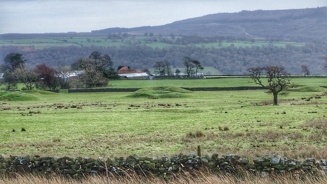
The shaft mounds survive as rounded hummocks in the pasture above the farm, photographed in 2015.
Pit mounds in two rows in the fields above Wethercote Farm.
Redevelopment
None.
Nearby mines
- Ankness Colliery — 4.7 miles (7.5 km) E
- Kepwick Colliery — 5.1 miles (8.2 km) W
- Rudland Colliery — 5.6 miles (9.0 km) E
- Sled Shoe Colliery — 8.4 miles (13.6 km) E
- Blakey Colliery — 8.6 miles (13.8 km) NE
Straight-line distance, within 9 miles (15 km). Show on the map.
Recorded claims
Individual factual claims, each attached to the source(s) that support it below. Where sources disagree, both are kept.
- The colliery has eighteen shafts in two rows on the hillside above Wethercote Farm in Bilsdale. 1
- It was leased from C. S. Duncombe in late December 1781 to Benjamin Barraclough and John Rush, a Bransdale coal miner, at £40 an acre for a twelve-inch seam, with wood for props and half a yard of coal to be left between bords. 2,1
- On 31 August 1787 1,552 square yards had been wrought at £20 an acre in a seam of four to eight inches, mean six, with £6 8s 3d due from John Rush. 2
- Before March 1787 William Peacock and William Dunning had taken the colliery, and on 25 March 1787 John Rush took it for a year and a half at £40 per twelve inches. 2,1
- The 1787 valuation listed the Low Pit, the High Pit, a pair of bellows, two ropes, eight corves, turngear, a water level, five shovels, ten picks, four hammers, an anvil and chains, £12 8s 6d in all. 2,1
- In 1793 the agent called it a tolerable lime coal that could not be done without and raised the rent a tenth. 2
- The colliery was probably worked in a single phase between 1782 and 1795. 2
- The coal workings above Wethercote Farm survive as mounds, probably eighteenth-century bell pits. 3
Photographs & further reading
The Northern Mine Research Society's page with the 1781 and 1787 leases and the valuation.
View sourceThe caving club's survey, with the colliery's coordinates, the 1787 measurement and the 1793 note.
View sourceSources
- (secondary) Weather Cote Colliery, Nawton — Northern Mine Research Society
- (secondary) The Moorland Collieries of North Yorkshire — North York Moors Caving Club
- (observational) Coal Workings, Wethercote Farm (photograph, 2015) — Geograph
Record created: 16 October 2026 · Last researched: 21 October 2026