 MineArchive
Sled Shoe Colliery
| Also known as | Sledge Shoe Colliery, Sledshoe Colliery |
|---|---|
| Location | Blakey Ridge, south of the Lion Inn, Farndale East, North Yorkshire — 54.3686, -0.9438 (exact) |
| Commodity | Coal |
| Type | Coal |
| Worked | By 1768–1796 |
| Maximum depth | Unknown. |
| Operators | Mathew Ryley (1792–1796), Christopher Slingsby Duncombe |
Overview
Some forty pits on either side of the road along Blakey Ridge, three-quarters of a mile south of the Lion Inn, with more at Sled Shoe Bridge and Kettle Howe, worked for lime coal before 1768 and almost exhausted when Mathew Ryley tried them again in 1792 for soft, mucky coal the farmers would not buy; he gave up in 1796.
History
Sled Shoe lies on Blakey Ridge where the Castleton to Hutton-le-Hole road runs along the crest, about three-quarters of a mile south of the Lion Inn. The colliery is a scatter of forty or so pits on either side of the road, with another group at Sled Shoe Bridge a little to the south and others around Kettle Howe to the north. It first appears in the Danby Coals Memorandum of 1768, and the ground had been worked for lime coal and was almost exhausted before Mathew Ryley took it. In 1791 the Duncombe estate agent D. Seaton noted a colliery about two miles south of Blakey with some coal said to be left, and that John Ryley, an old collier with money, offered to take, open and work it.
Ryley began in 1792. Seaton reported that lime coals had been got and Ryley expected some were left; he had got a few that summer, but they were of soft mucky quality and the farmers would not buy them except in a summer like the last, when no others were to be had. In 1793 he called them good lime coals that lay well for sale, but in a thin seam that cost a deal of getting, and raised the rent a tenth, from £23 6s 8d to £25 1s an acre. The seam was seven to seven and a half inches thick; the yearly measurements of 1,108 to 2,492 square yards suggest 240 to 500 tons a year from 1792 to 1795. By the 1796 measurement the work was shut up, Ryley having worked a little after the last measuring before the coals were quite out, and he was charged £2 12s 6d for it. He gave Sled Shoe up that year and was in partnership with John Featherston at Blakey from 1797 to 1801; the Lastingham parish registers have him as a collier between 1782 and 1794.
Geology
A thin moorland lime coal, seven to seven and a half inches thick in 1792 to 1795, worked from shallow pits along the crest of Blakey Ridge.
Geological setting: Sedimentary Beds and Seams (historical documentary reference)
Workings
Some forty shallow pits either side of the ridge road, with further groups at Sled Shoe Bridge and Kettle Howe, worked by the acre and measured yearly by the estate agent.
Closure
The coal was almost worked out before 1792, poor in quality and costly to get in so thin a seam; Ryley shut the work up in 1796 and moved to Blakey.
What remains
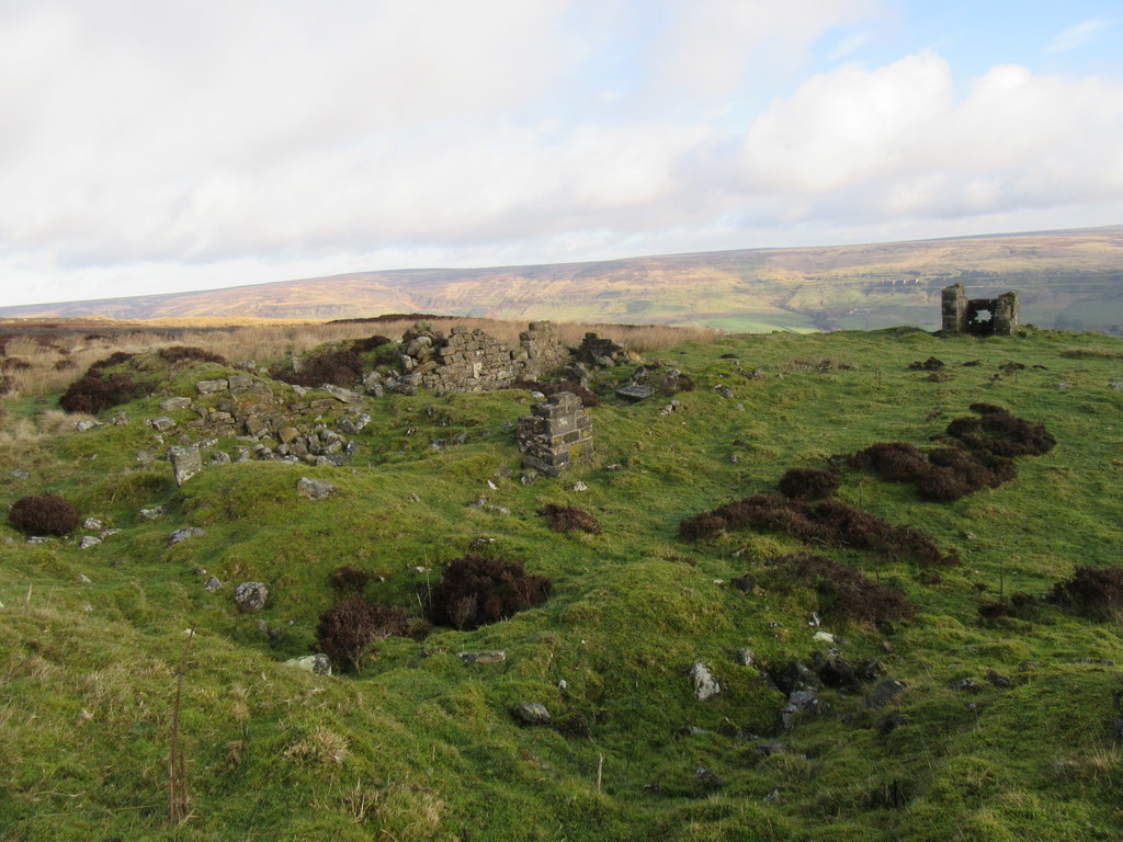
The pit hollows survive on the ridge; the ruins of the Sledge Shoe building stand nearby on the crest.
Pit mounds and hollows along the ridge road; the ruin called Sledge Shoe.
Redevelopment
None.
Nearby mines
- Blakey Colliery — 1.5 miles (2.3 km) N
- Rudland Colliery — 3.5 miles (5.6 km) SW
- Ankness Colliery — 4.2 miles (6.8 km) SW
- Rosedale Ironstone Mines — 4.7 miles (7.5 km) SE
- Glaisdale Ironstone Mine — 7.5 miles (12.1 km) NE
Straight-line distance, within 9 miles (15 km). Show on the map.
Recorded claims
Individual factual claims, each attached to the source(s) that support it below. Where sources disagree, both are kept.
- The colliery comprises some forty pits on either side of the Castleton to Hutton-le-Hole road on Blakey Ridge, three-quarters of a mile south of the Lion Inn, with other groups at Sled Shoe Bridge and Kettle Howe. 1
- The colliery first appears in the Danby Coals Memorandum of 1768. 2
- In 1791 the agent noted a colliery about two miles south of Blakey with some coal said to be left, which John Ryley, an old collier with money, offered to take and work. 2
- Mathew Ryley tried the almost exhausted ground in 1792, getting a few soft mucky lime coals the farmers would not buy except when no others were to be had. 2,1
- In 1793 the rent was raised a tenth, to £25 1s an acre, the coal being good but in a thin seam that cost a deal of getting. 2
- Between 1792 and 1795 the seam measured seven to seven and a half inches and the area worked 1,108 to 2,492 square yards a year, about 240 to 500 tons. 1
- By the 1796 measurement the work was shut up; Ryley gave Sled Shoe up that year and partnered John Featherston at Blakey from 1797 to 1801. 2,1
Photographs & further reading
The Northern Mine Research Society's page with Seaton's reports and the 1792 to 1796 measurements.
View sourceThe caving club's survey, with the colliery's coordinates and the 1768 to 1796 record.
View sourceSources
- (secondary) Sled Shoe Colliery, Farndale East — Northern Mine Research Society
- (secondary) The Moorland Collieries of North Yorkshire — North York Moors Caving Club
- (observational) Sledge Shoe (photograph, 2020) — Geograph
Record created: 16 October 2026 · Last researched: 21 October 2026