 MineArchive
Roslin Colliery
| Also known as | The Moat, Moat Colliery, Roslin Moat Colliery |
|---|---|
| Location | Roslin, Lasswade parish, Midlothian — 55.8586, -3.1814 (exact) |
| Commodity | Coal |
| Type | Coal |
| Worked | c. 1876–1969 |
| Maximum depth | The No. 2 upcast shaft was 294 metres deep and 3.35 metres in diameter, and was deepened in 1922. |
| Operators | Glasgow Iron Company (1876–?), Shotts Iron Company (1901–1946), National Coal Board (1947–1969) |
Overview
A Midlothian colliery beside Roslin, opened about 1876 by the Glasgow Iron Company under the name The Moat and re-sunk by the Shotts Iron Company from 1901. It grew steadily through the twentieth century, from 164 employed in 1905 to 770 in 1952, working a long list of Midlothian seams including the Peacock, Corbie, Glass, Flex and South Parrot. A brickworks stood alongside it from the 1930s, using the colliery's own shale. Roslin closed in 1969, and its coal had been washed at the neighbouring Ramsay colliery.
History
Roslin sits in the Midlothian coalfield, the same basin that carries Lady Victoria at Newtongrange and Lingerwood beside it, and the pit here is a relative latecomer to it. The site was opened around 1876 by the Glasgow Iron Company and was known as The Moat, a name that has outlasted the colliery: the ground is still called the Moat site. The Shotts Iron Company re-sank it, with sinking and production commencing between 1901 and 1903, and worked it until nationalisation.
The Lists of Mines show a pit that kept growing while others in the county shrank: 164 employed in 1905, 330 in 1910, a dip to 222 in 1915, then 431 in 1920, 450 in 1923, 605 in 1933, 650 in 1940, 621 in 1947 and 770 in 1954. The average workforce over its life was around 754, and the peak, 770, came in 1952. In 1948 it was producing 777 tons a day, about 194,250 tons a year, with 765 employed. The seams worked change with almost every return: Corbie, Glass, North Peacock and Peacock in 1905; Corbie, North Coal, Peacock and Splint in 1910; Flex, Peacock and South Parrot in 1915; Corbie, Flex, Glass, North Greens, Peacock and South Parrot in 1920; and Beattie, Craigie, North Greens, Peacock and South Parrot by 1954. Ironstone appears alongside coal in the 1920 output return.
The colliery had a second industry attached to it. The Shotts Iron Company started Roslin Brick Works in the 1930s and ran it until 1947, when the National Coal Board took it over with everything else; the National Record of the Historic Environment classifies the site as colliery and brickworks together and holds photographs of its kilns, including a 26-chamber kiln and a 12-chamber kiln built in 1953. The colliery closed in 1969. Its coal had been washed not on site but at Ramsay colliery at Loanhead.
Geology
Roslin worked the Coal Measures of the Midlothian basin, a syncline whose seams carry names used across the county: Peacock and North Peacock, Corbie, Glass, Splint, Flex, South Parrot, North Greens, Beattie and Craigie. The variety in the returns, with a different combination of seams named almost every five years, reflects a pit working several thin coals in rotation rather than one thick seam. Ironstone was returned alongside coal in 1920, and the shale worked with the coal fed the brickworks that stood on the same site.
Geological setting: Anticlines and Synclines (historical documentary reference), Sedimentary Beds and Seams (well documented example)
Workings
Two shafts, the No. 2 being the upcast at 294 metres and 3.35 metres in diameter, deepened in 1922. The colliery had no washery of its own; its coal went to Ramsay colliery at Loanhead to be washed. A mineral spur from the Edinburgh, Loanhead and Roslin Railway served the pit, part of the network that also carried Bilston Glen's traffic. Alongside the colliery the Shotts Iron Company ran a brickworks from the 1930s, whose surviving record includes a 26-chamber kiln and a 12-chamber kiln of 1953.
Closure
Roslin closed in 1969, near the end of the run of Midlothian closures that also took Whitehill and, later, Lady Victoria. It was not a small or failing pit at the end: the 1954 return is its highest recorded employment at 770, and the peak workforce is given as 770 in 1952. No account of the specific reasons for the closure is recorded, and the brickworks alongside outlasted the colliery's early years under the Coal Board rather than the other way round.
What remains
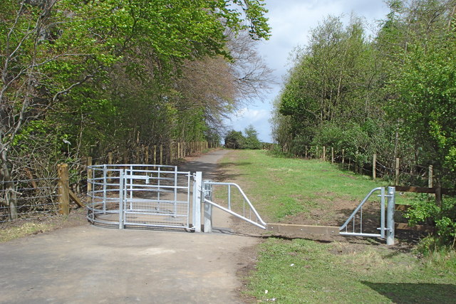
The colliery is gone and the ground is public open space. Kissing gates and horse gates were put in at the end of April 2009 to give access to a developing network of paths and bridleways across what the signage and local usage still call the Moat site, the old colliery and brickworks ground. The National Record of the Historic Environment holds a set of photographs of the brickworks buildings, kilns and machine wing before clearance.
No standing colliery structures are recorded. The brickworks was photographed in detail for the national record, including the interior and the railway line at the top of the ramp by the hopper, which suggests it stood long enough to be surveyed; what if anything is left above ground is not known.
Redevelopment
The Moat site has been laid out for public access, with paths and bridleways and gates wide enough for wheelchairs and horse riders installed in 2009.
Nearby mines
- Bilston Glen Colliery — 1.2 miles (2.0 km) NE
- Burghlee Colliery — 1.3 miles (2.1 km) NE
- Pentland No. 1 and 2 Mines — 1.7 miles (2.8 km) N
- Whitehill Colliery — 1.8 miles (2.9 km) E
- Loanhead (Ramsay) Colliery — 2.0 miles (3.2 km) NE
Straight-line distance, within 9 miles (15 km). Show on the map.
What's uncertain
Points where sources disagree or the record could not be settled; both accounts are kept. All open questions in the archive.
- The BGS mine-plans catalogue holds a Mining Remediation Authority abandonment plan titled 'Roslin' (catalogue S660, Browns, dated 1932); the catalogue gives no location and the plan's details do not clearly tie it to this working, so it may belong to another of the same name. (uncertain) 4
Recorded claims
Individual factual claims, each attached to the source(s) that support it below. Where sources disagree, both are kept.
- Government Lists of Mines record 164 employed in 1905, 330 in 1910, 222 in 1915, 431 in 1920, 605 in 1933, 621 in 1947 and 770 in 1954. 1
- The seams returned change with almost every List of Mines: Corbie, Glass, North Peacock and Peacock in 1905; Corbie, North Coal, Peacock and Splint in 1910; Flex, Peacock and South Parrot in 1915; Corbie, Flex, Glass, North Greens, Peacock and South Parrot in 1920; and Beattie, Craigie, North Greens, Peacock and South Parrot in 1954. Ironstone was returned alongside coal in 1920. 1
- The colliery was opened around 1876 by the Glasgow Iron Company and known as The Moat, then re-sunk by the Shotts Iron Company, with sinking and production commencing between 1901 and 1903. 2
- The No. 2 upcast shaft was 294 metres deep and 3.35 metres in diameter and was deepened in 1922. In 1948 the colliery produced 777 tons a day, about 194,250 tons a year, with 765 employed; the coal was washed at Ramsay colliery. 2
- The Shotts Iron Company started Roslin Brick Works in the 1930s and ran it until the National Coal Board took over in 1947. The national monument record classifies the site as colliery and brickworks and holds photographs of a 26-chamber kiln and a 12-chamber kiln built in 1953. 3,2
- The BGS mine-plans catalogue holds a Mining Remediation Authority abandonment plan titled 'Roslin' (catalogue S660, Browns, dated 1932); the catalogue gives no location and the plan's details do not clearly tie it to this working, so it may belong to another of the same name. (uncertain) 4
Photographs & further reading
Owners, grid reference, output types and employment by List of Mines year from 1905 to 1954, the seams worked in each return, and the men recorded as killed at the colliery.
View sourceThe national monument record for the site, with an exact grid reference and a set of photographs of the brickworks buildings, its 26-chamber and 1953 12-chamber kilns, the machine wing and the railway line by the hopper.
View sourceThe clearest account located of the colliery's ownership and dates as well as the brickworks: the Glasgow Iron Company's opening around 1876 as The Moat, the Shotts Iron Company re-sinking of 1901 to 1903, shaft dimensions, the 1948 output and workforce figures, and the 1969 closure.
View sourceSources
- (primary) Roslin Colliery — Durham Mining Museum
- (secondary) Roslin Brickworks, Roslin, Midlothian — Scotland's Brick and Tile Manufacturing Industry
- (primary) Roslin Colliery and Brickworks, NRHE 82866 — National Record of the Historic Environment, Historic Environment Scotland
- (primary) BGS / Mining Remediation Authority mine plans: ROSLIN — British Geological Survey / Mining Remediation Authority
Record created: 10 September 2026 · Last researched: 10 September 2026