 MineArchive
Norwich Chalk Mines
| Also known as | Earlham Road chalk mine |
|---|---|
| Location | Beneath Norwich, in and around the medieval city, Norfolk — 52.6320, -1.3120 (approximate) |
| Commodities | Chalk, Flint |
| Type | Mineral |
| Worked | 11th century–19th century |
| Maximum depth | Between 12 and 90 feet below the surface, in tunnels 6 to 16 feet high. |
Overview
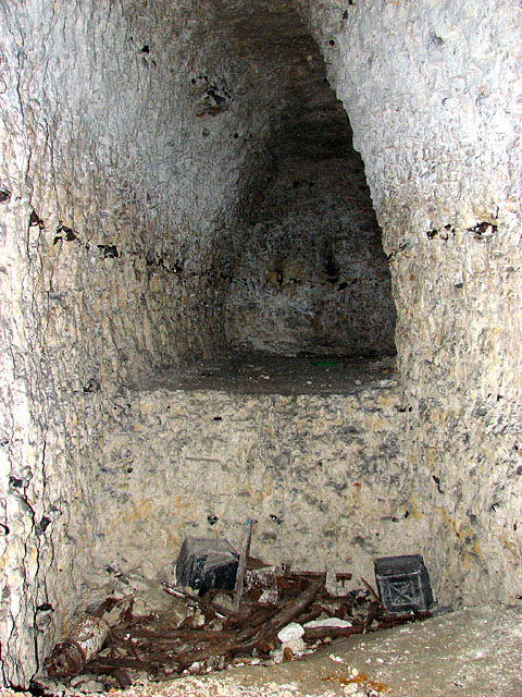
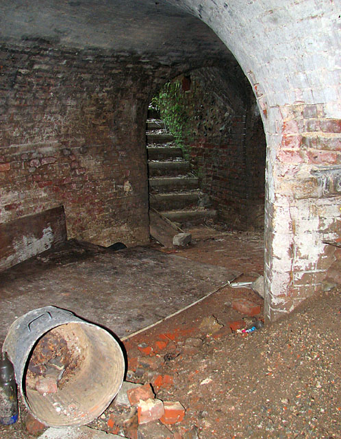
The city of Norwich is undermined at shallow depth by abandoned workings for chalk and flint, believed to date back to the eleventh century. The chalk was burnt into lime for mortar and the flint used as building stone — the material of the city walls, finished in 1343, and of much of medieval Norwich. Early working was by surface pits and quarries, later by underground tunnels arranged in a grid between twelve and ninety feet down, six to sixteen feet high and six to twelve wide. Some were later wine stores and then air-raid shelters. On 3 March 1988 a number 26 bus dropped into a twenty-six-foot hole that opened in Earlham Road.
History
Chalk and flint have been taken from beneath Norwich since about the eleventh century. The chalk was burnt into lime for mortar, and the flint quarried with it was used as building stone; the two together are the fabric of medieval Norwich, from the city walls completed in 1343 to the flint-and-lime-mortar work still visible across the city. The earliest workings were surface pits and quarries. As those were exhausted the extraction went underground, and the tunnels are known all around the medieval city and its outskirts, arranged in a grid-like fashion between twelve and ninety feet below the surface and varying from six to sixteen feet in height and six to twelve in width. When the mines closed the tunnels found other uses. Those beneath Earlham Road became wine stores, and were later used as air-raid shelters. The consequence has been a long history of subsidence in a city built over its own quarries. On Thursday 3 March 1988 a number 26 bus fell into a hole twenty-six feet deep that opened in Earlham Road — the incident that made the workings publicly notorious. The collapses at the Earlham Road mine are described as well developed, the result of inadequate rock cover, great age, poor rock quality and the disturbance that comes of being under a city.
Geology
The Upper Chalk beneath Norwich, carrying the flint nodules that were quarried with it. Chalk burns to quicklime and slakes for mortar; flint, hard and unworkable but durable, is the building stone of a region with no freestone of its own — which is why the two were taken together and why medieval Norwich is a city of flint set in lime. The chalk here is of poor rock quality by mining standards, and that, with shallow cover and great age, is why the workings collapse.
Workings
Surface pits and quarries first, then underground tunnels driven in a grid-like pattern — between twelve and ninety feet deep, six to sixteen feet high and six to twelve feet wide — all around the medieval city and its outskirts. Some of the Earlham Road workings were later converted to wine stores and then to air-raid shelters.
Closure
The workings were abandoned as mines; no closing date is recorded for them as a group. What has continued is their afterlife — as cellars, wine stores and shelters, and as a long-running subsidence liability for the city above them.
What remains
Abandoned and largely inaccessible, but very much present: the workings are a recognised ground-stability risk to property across Norwich, and have been the subject of underground investigation. The 1988 Earlham Road collapse, in which a bus fell twenty-six feet into the road, is the best-known instance of what shallow abandoned chalk workings do to a city built over them.
None above ground; the workings are the remains.
Related mines
- Bury St Edmunds Chalk Mines — The two East Anglian cathedral towns solved the same problem the same way: no local freestone, so flint for the walling and mined chalk burnt for the lime that bound it — and both are now undermined by the workings, Norwich losing a bus into Earlham Road in 1988 and Bury St Edmunds an entire housing estate at Jacqueline Close.
Nearby mines
- Merrylees Drift Mine — 1.6 miles (2.5 km) N, Leicestershire
- Desford Colliery — 2.4 miles (3.9 km) NW, Leicestershire
- Bagworth Colliery — 2.7 miles (4.4 km) N, Leicestershire
- Nailstone Colliery — 3.6 miles (5.7 km) NW, Leicestershire
- Groby Granite Quarry — 3.8 miles (6.1 km) NE, Leicestershire
Straight-line distance, within 9 miles (15 km). Show on the map.
Recorded claims
Individual factual claims, each attached to the source(s) that support it below. Where sources disagree, both are kept.
- The chalk mines are believed to date back to the eleventh century, the chalk extensively mined beneath the city and burnt into lime for mortar; flint was mined with it and used as building stone, and flint and lime-mortar construction is visible across Norwich, including in the city walls completed in 1343. 1
- The tunnels lie between twelve and ninety feet below the surface, are known all around medieval Norwich and its outskirts, vary from six to sixteen feet in height and six to twelve in width, and are arranged in a grid-like fashion. 1
- On Thursday 3 March 1988 a number 26 bus fell into a hole twenty-six feet deep that opened in Earlham Road, Norwich. 1
- Collapses at the Earlham Road mine have been found to be well developed, due to inadequate rock cover, great age, poor rock quality and disturbance from the urban location; the workings beneath Earlham Road had become wine stores and were subsequently used as air-raid shelters. 1
Photographs & further reading
A ground-risk assessment of the workings under the city: their age, depth, dimensions and layout, and why they go on collapsing.
View sourceSources
- (secondary) Property at risk from Norwich’s hidden chalk mining legacy — Groundsure
- (secondary) Property at risk from Norwich’s hidden chalk mining legacy — Today's Conveyancer
Record created: 7 September 2026 · Last researched: 7 September 2026