 MineArchive
North Selby Mine
| Location | about 1 mile north-east of Escrick, North Yorkshire — 53.8910, -1.0156 (approximate) |
|---|---|
| Commodity | Coal |
| Type | Coal |
| Worked | January 1991–July 1997 |
| Maximum depth | 1,043 m (the shafts), with an inset to the Barnsley seam at 991 m. |
| Operators | Cementation Mining (1978–1986), National Coal Board (1976–1987), British Coal Corporation (1987–1994), UK Coal (1995–1997) |
Overview
The northernmost and deepest of the Selby coalfield pits, near Escrick, with shafts frozen through the waterlogged sandstone and sunk to over a thousand metres. It took eight years to sink and began mining only in January 1991; floor heave caused by its depth closed it in July 1997, when its take passed to Stillingfleet.
History
Planning permission for two 7.315-metre (24 ft) shafts at North Selby was granted in 1977, and Cementation Mining Ltd began sinking them, in 1978 according to the Northern Mine Research Society and in July 1979 according to the Railway to Greenway timeline. To pass the waterlogged Bunter Sandstone into the Upper Permian Marl the ground was frozen from the surface to around 280 metres. The shafts were not complete until 1986, at 1,043 metres with an inset to the Barnsley seam at 991 metres, the deepest in the complex, and mining began in January 1991. Like the other satellite pits it wound no coal: output went by conveyor to Gascoigne Wood, from where it was sent by rail to the Aire valley power stations. Recorded output was 1,253,000 tonnes in 1992, 1,684,000 in 1995 and 1,537,000 in 1996. Depth brought extreme floor heave in the roadways serving the faces, and this with other geological problems led to the mine's closure in July 1997, when its take was merged with Stillingfleet's. A photographer's account puts the combination with Stillingfleet in 1998 and the end of mining on site in 2000, and says North Selby and Whitemoor may have been marked for closure as early as 1992, though North Selby's coal was reckoned the cheapest per ton in the UK.
Geology
The Barnsley seam at 991 metres, beneath waterlogged Bunter (Sherwood) Sandstone and Upper Permian Marl, which the shafts crossed by ground freezing to about 280 metres. The depth caused extreme floor heave in the roadways.
Geological setting: Sedimentary Beds and Seams (well documented example)
Workings
Two 7.315-metre shafts, 1,043 metres deep, frozen through the upper 280 metres and inset to the Barnsley seam at 991 metres. Coal was conveyed underground to Gascoigne Wood; after 1997 the take was worked from Stillingfleet.
Closure
Extreme floor heave in the roadways, caused by the mine's depth, and other geological problems led to closure in July 1997 and the merger of its take with Stillingfleet's.
What remains
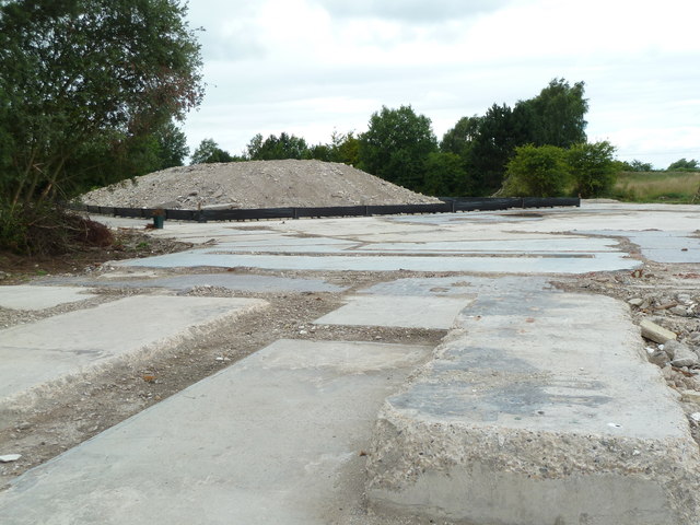
Derelict in 2012-13, with the office block reduced to rubble, a pump house and weighbridge standing and the bathhouse and medical room open; demolition fencing was reported on the site in May 2017. A 2013 photograph shows the pithead area as cleared concrete slabs.
Concrete hardstanding, a weighbridge and the rail tracks for mine cars were recorded in 2013; the headgear and winding houses had gone.
Redevelopment
Converted to mixed commercial use as a business park by December 2005, according to Wikipedia; later proposals for a renewable-energy site using waste as feedstock followed from 2009.
Related mines
- Gascoigne Wood Mine — North Selby's coal went underground by conveyor to Gascoigne Wood.
- Stillingfleet Mine — North Selby's take was merged with Stillingfleet's when it closed in July 1997.
Nearby mines
- Stillingfleet Mine — 5.9 km SW
- Riccall Mine — 7.4 km S
- Whitemoor Mine — 8.6 km S
- Wistow Mine — 11.5 km SW
Straight-line distance, within 15 km. Show on the map.
What's uncertain
Points where sources disagree or the record could not be settled; both accounts are kept. All open questions in the archive.
- Cementation Mining Ltd began sinking the shafts in 1978. (disputed) 1
- Shaft sinking started at North Selby in July 1979. (disputed) 2
- The shafts are given as 1,043 m (NMRS), 'reaching 1040 meters' (Abandoned Britain) and 1,046 m (Mark Hillyer). (uncertain) 1,3,4
- Extreme floor heave and other geological problems led to North Selby's closure and the merger of its take with Stillingfleet in July 1997. (disputed) 5,1
- North Selby continued until 1998, when it was combined with Stillingfleet, and mining on site stopped in 2000. (disputed) 3
- The Whitemoor and North Selby sites were converted to mixed commercial use as business parks by December 2005. (uncertain) 5
Recorded claims
Individual factual claims, each attached to the source(s) that support it below. Where sources disagree, both are kept.
- Planning permission for two 7.315 m shafts was granted in 1977; the shafts were frozen from the surface to about 280 m to pass the Bunter Sandstone and completed in 1986 to 1,043 m, with an inset to the Barnsley seam at 991 m. 1
- Cementation Mining Ltd began sinking the shafts in 1978. (disputed) 1
- Shaft sinking started at North Selby in July 1979. (disputed) 2
- The shafts are given as 1,043 m (NMRS), 'reaching 1040 meters' (Abandoned Britain) and 1,046 m (Mark Hillyer). (uncertain) 1,3,4
- Mining began in January 1991. 1,4
- Known output: 1,253,000 t (1992), 1,684,000 (1995), 1,537,000 (1996). 1
- Extreme floor heave and other geological problems led to North Selby's closure and the merger of its take with Stillingfleet in July 1997. (disputed) 5,1
- North Selby continued until 1998, when it was combined with Stillingfleet, and mining on site stopped in 2000. (disputed) 3
- In September 2013 the main office was rubble, the pump house and weighbridge remained, and the main building was locked; demolition fencing was reported in May 2017. 6
- The BGS / Mining Remediation Authority mine-plans catalogue holds plans filed under 'NORTH SELBY'. 7
- The Whitemoor and North Selby sites were converted to mixed commercial use as business parks by December 2005. (uncertain) 5
Photographs & further reading
A photographer's 2012-13 series on the derelict surface buildings, with an account of the pit's short life.
View sourceA 2013 visit report on the weighbridge, pump house and rail tracks, with a 2017 reply describing demolition works.
View sourceSources
- (secondary) North Selby Mine — Northern Mine Research Society
- (secondary) Selby Coalfield Timeline — Railway to Greenway (York Greenways)
- (observational) North Selby Mine (Selby Complex), 2012-2013 — Abandoned Britain
- (observational) North Selby Mine | Abandoned Yorkshire Coal Mine — Mark Hillyer
- (secondary) Selby Coalfield — Wikipedia
- (observational) Report - North Selby Mine, Escrick, N Yorks Sept 13 — 28DaysLater
- (primary) BGS / Mining Remediation Authority mine plans: NORTH SELBY — British Geological Survey
Record created: 21 September 2026 · Last researched: 21 September 2026