 MineArchive
New Ingleton Colliery
| Also known as | Ingleton New Colliery |
|---|---|
| Location | Ingleton, North Yorkshire — 54.1470, -2.4690 (approximate, low confidence) |
| Commodity | Coal |
| Type | Coal |
| Worked | 1912 (sinking)–February 1936 |
| Maximum depth | 265 yards |
| Operators | New Ingleton Colliery Company (1912–1936) |
Overview
The last and largest colliery of the Ingleton coalfield, sunk from 1912 beside the Keighley-Kendal road to 265 yards. It employed about 350 by 1926 and built the New Village for its miners, and closed in February 1936.
History
New Ingleton Colliery was sunk by the New Ingleton Colliery Company, a syndicate that bought the Ingleton mining interests shortly before 1913. Two shafts went down beside the Keighley-Kendal turnpike, now the A65, to 265 yards. Sinking to the Six Foot coal began in 1912, and production started in 1914. The war held up the second shaft until 1917, so at first the shallower Ten and Nine Foot seams, unknown until the sinking found them, were worked instead. For the only time an Ingleton colliery had a main-line railway connection.
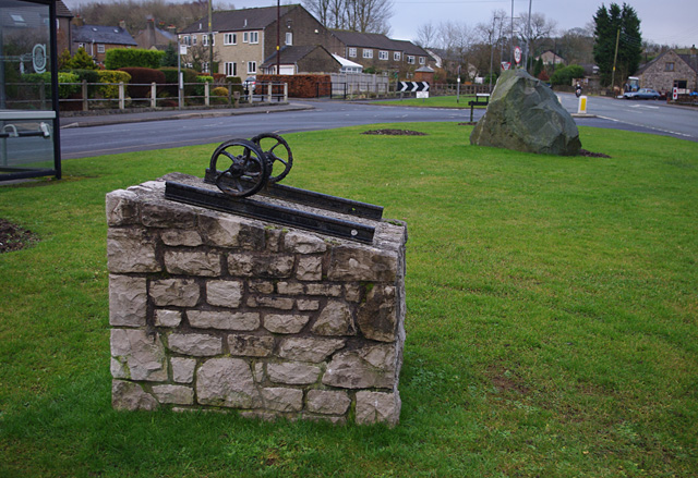
Most of the work was in the Four Foot, which proved regular, free of washouts and faults and with a good roof. The company built the Model, or New, Village from 1913 for the families drawn by the pit's wages. By 1926 about 350 miners were employed, and electric power had come in, with electric coal-cutters replacing compressed-air machines and endless-rope haulage on the main roads. The 1920s brought over-capacity and quotas, and after a final year of industrial trouble the struggling company closed the colliery in February 1936, ending mining at Ingleton. A memorial to three centuries of Ingleton coal mining was unveiled across the road from the site on 14 June 2004.
Geology
Ingleton coalfield Coal Measures, dipping steeply north from the South Craven Fault: the Ten Foot, Nine Foot, Four Foot, Yard and Six Foot seams.
Workings
Two shafts to 265 yards beside the A65; electric coal-cutters and endless-rope haulage by 1926; a main-line railway connection.
Closure
Closed in February 1936 by a company in financial difficulty after a year of industrial problems.
What remains
A memorial of 2004 with a mine-tub wheelset on rails stands on a green across the A65 from the site; the New Village built for the miners survives.
Redevelopment
Unknown.
Related mines
- Wilson Wood Colliery — Successive collieries of the Ingleton coalfield; the New Ingleton company bought the old Ingleton interests.
Nearby mines
- Wilson Wood Colliery — 0.3 miles (0.4 km) NE
- Meal Bank Quarry — 0.7 miles (1.1 km) N
- Clintsfield Colliery — 4.4 miles (7.0 km) SW, Lancashire
- Arcow Quarry — 6.8 miles (10.9 km) E
- Dry Rigg Quarry — 6.9 miles (11.2 km) E
Straight-line distance, within 9 miles (15 km). Show on the map.
Recorded claims
Individual factual claims, each attached to the source(s) that support it below. Where sources disagree, both are kept.
- Sunk to the Six Foot between 1912 and 1914, when production began. 1,2
- Two shafts were sunk beside the Keighley-Kendal road to 265 yards. 3
- About 350 miners were employed by 1926. 3
- The New, or Model, Village was built from 1913 for its workers. 3
- Closed in February 1936, ending coal mining at Ingleton. 1
- Its Four Foot and Yard plans are dated 1940. 4
- A coal-mining memorial stands across the A65 from the site. 1,5
Photographs & further reading
The Ingleton coalfield's seams and collieries from the 1600s to New Ingleton's closure in 1936.
View sourceJohn Bentley's history of the coalfield and its pits.
View sourceSources
- (secondary) Ingleton Coal — Northern Mine Research Society
- (secondary) Ingleton Coalfield — Wikipedia
- (secondary) An introduction to Ingleton coalfield and colliery (J. Bentley, Contrebis 20) — Lancaster Archaeological and Historical Society
- (primary) Mine plan: Ingleton New, Four Foot — British Geological Survey
- (observational) Coal mining memorial, Ingleton (photograph) — Geograph
Record created: 3 October 2026 · Last researched: 3 October 2026