 MineArchive
Meal Bank Quarry
| Also known as | Ingleborough Patent Lime Works |
|---|---|
| Location | Ingleton, North Yorkshire — 54.1569, -2.4662 (approximate) |
| Commodity | Limestone |
| Type | Quarry |
| Worked | Lime burning by the early 19th century; Hoffmann kiln 1868–1909 |
| Maximum depth | An open quarry, not a shaft mine; no depth figure has been located. |
| Operators | Craven Lime Company (1864–1909) |
Overview
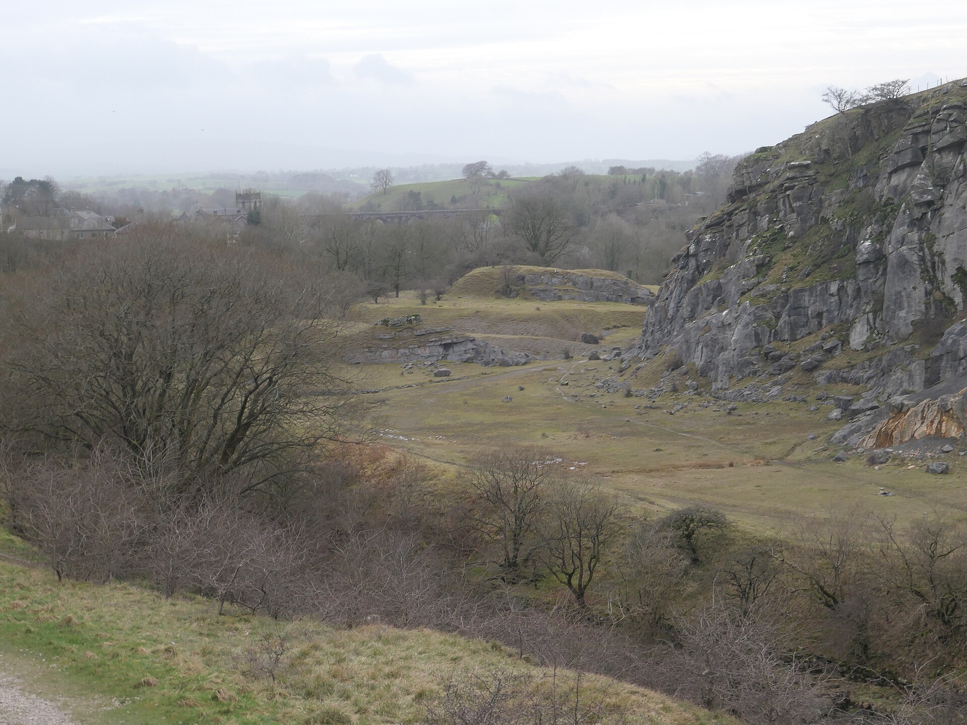
A limestone quarry and lime works north of Ingleton, where in 1868 John Clark and Michael Wilson built what is thought to be the earliest Hoffmann kiln applied to lime burning in England. The works ran as the Ingleborough Patent Lime Works until 1909; the kiln's 70 m ring of walls and arched entrances still stands, partly ruined, below the quarry face.
History
Limestone had been quarried on a small scale at Meal Bank for centuries and commercial lime burning was going on by the early 19th century; the 1846 Ordnance Survey map shows kilns and quarries here, probably draw kilns, north and east of the later kiln, though how long they had been at work is not known. In 1864 John Clark and Michael Wilson, two experienced lime burners from Austwick who held the lease of the Giggleswick lime works, took over the old kilns and quarry. They had acquired rights to the patent for the horizontal ring kiln designed by Friedrich Hoffmann and patented in 1858, a kiln developed for brick making that transformed lime burning by allowing large-scale continuous production, and in 1868 they began building one at Meal Bank. The site was renamed the Ingleborough Patent Lime Works, and the new kiln turned out between 40 and 60 tons of high-grade lime a day, sold across the north of England and particularly to the chemical industry. By 1872 demand had grown enough for the partners to take the lease of a second works at Langcliffe, some 20 km to the south-east, and to reform the company as the Craven Lime Company. The kiln was extended eastward in 1893, and in 1892 a half-mile railway was built to the Ingleton branch of the London and North Western Railway, replacing horse and cart and, it was reckoned, allowing the company to double its output. The works were still profitable in the early 1900s, but the market crashed in 1908 and the quarry and kiln closed the following year.
Geology
The works lie on the western part of the Yoredale Series of the Carboniferous Limestone. Limestone has been dug and burnt around Ingleton since medieval times, for improving land and for mortar, plaster and building stone, and lime working expanded across the western Dales in the late 18th century.
Workings
The heart of the works was the Hoffmann kiln, a stone structure rectangular in plan with semicircular ends, its outer face sloping steeply inwards and pierced by regularly spaced entrances. A vaulted tunnel runs in a ring inside the walls around a central smoke chamber. Crushed limestone was stacked in the tunnel through the entrances and coal tipped between the stacks from feeder holes in the roof; two fires worked slowly round the ring, each burning two or three stacks every few days, with new stone loaded ahead of the burn and quicklime drawn out behind it, so production never stopped. Dampers worked from the top controlled the draught, and the fume collected in the smoke chamber and went out through a 65 m flue up the hillside to a chimney. The kiln was built in two phases: 47.6 m by 24 m with fourteen brick-lined entrances, extended in 1893 to 70 m and eighteen, standing about 4.5 m high. A 3 m platform carried a tramway round the kiln and outside it a stone lined dock held the railway wagons that took the lime away. Coal was stored on a walled platform up the slope level with the kiln top, reached by an inclined tramway, and barrowed across wooden bridges to the chutes. The quarry east of the kiln was worked by blasting, powder being tamped into natural crevices in the face rather than drilled holes and kept in two powder houses set well away from the works beside the river. Stone was sorted, crushed and graded on the quarry floor, where the buildings include what has been read as a rock-cut wheel pit.
Closure
The lime market crashed in 1908 and the quarry and kiln shut down the following year. The site was stripped during the First World War, leaving the ruins of the Hoffmann kiln.
What remains
The kiln, the quarry, the spoil tips, the tramways and the mineral railway are a scheduled monument. The kiln has deteriorated since the works closed and is partly ruined: the outer walls are broadly intact except at the eastern end, and parts of the tunnel and smoke chamber have fallen in, but the main structural and working elements can still be made out. The chimney has been demolished and survives as a pile of rubble, though the flue can be traced along its whole length.
The Hoffmann kiln with its ring tunnel, smoke chamber and arched entrances; the flue up the hillside; the coal-store platform, its retaining wall and inclined tramway; the quarry face, about 400 m of cliff, with stone-lined drainage channels on the floor; the crushing complex and probable wheel pit; the revetted spoil tips along the river; the tramway lines and the railway depot and tunnel.
Redevelopment
None. The quarry and kiln are overgrown woodland and scrub on the edge of Ingleton.
Nearby mines
- Clintsfield Colliery — 7.7 km SW, Lancashire
- Dry Rigg Quarry — 11.3 km E
- Arcow Quarry — 11.5 km E
- Foredale Quarry — 11.7 km E
Straight-line distance, within 15 km. Show on the map.
Recorded claims
Individual factual claims, each attached to the source(s) that support it below. Where sources disagree, both are kept.
- In 1864 John Clark and Michael Wilson, lessees of the Giggleswick lime works, took over the existing kilns and quarry at Meal Bank, and in 1868 began building a Hoffmann kiln there. 1,2
- The Meal Bank kiln is thought to be one of the earliest applications of Hoffmann's design to lime burning built in England, and the first of its type in the north of England. 1,2
- The Hoffmann kiln produced between 40 and 60 tons of high-grade lime a day, sold across the north of England and particularly to the chemical industry. 2
- The kiln was built 47.6 m by 24 m with fourteen brick-lined entrances and extended eastward in 1893 to a length of 70 m and eighteen entrances, standing about 4.5 m high. 1
- The lime market crashed in 1908 and the kiln and quarry were shut down a year later. 2
Photographs & further reading
The Yorkshire Dales National Park Authority's gazetteer entry, with Clark and Wilson's careers, the kiln's daily output and the 1908 crash that closed the works.
View sourceSources
- (primary) Meal Bank Quarry Hoffmann kiln, quarry and lime works, Ingleton (List entry 1020889) — Historic England
- (primary) Meal Bank, Ingleton (Yorkshire Dales Historic Environment Record) — Yorkshire Dales National Park Authority
Record created: 22 September 2026 · Last researched: 22 September 2026