 MineArchive
Nant y Car South Mine
| Also known as | Nant y Car Mine, Nant-y-Car South Lead Mine, South Nant-y-Car Mine |
|---|---|
| Location | North bank of the Rhiwnant, Claerwen valley, Llanwrthwl, Powys — 52.2348, -3.6328 (exact) |
| Commodities | Lead, Copper, Zinc |
| Type | Metal |
| Worked | 18th century–1883 |
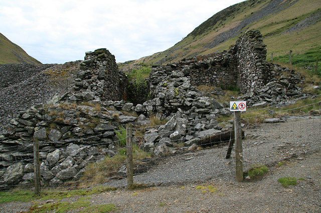
Nant y Car South was a lead, zinc and copper mine on the north bank of the Rhiwnant, facing Dalrhiw across the stream in the hills above the Claerwen. It was tried in the eighteenth century, worked from the 1840s and developed mainly in the 1860s and 1870s under a succession of owners, until a richer lode further up the valley drew the work away in 1883. Its crusher house still stands over four metres high, and the site is a scheduled monument.
Location
Recorded location. The large pin is this mine; the small round markers are the nearest mines on record. Click one for its page. View on full map
History
The lode was tried in the eighteenth century, and mining in earnest dates from the 1840s and early 1850s. Lead and zinc ores were commoner here than copper. The Nant y Car concern was wound up in 1859 and revived in 1863 under B. B. Popplewell, and most of what can be seen belongs to the twenty years that followed. The mine passed to George Tetley in 1872, to Mrs Tetley in 1875 and to C. W. Seccombe in 1878.
A single waterwheel did double duty, turning the crusher rolls and working the pump rods in the engine shaft. Round it grew a compact dressing floor: ore bins fed from the shaft by a tramway, a picking floor, jigs and a round buddle, all linked by covered stone leats.
About 1883 Seccombe found a new and richer lode at the head of the valley and developed it as the Nantygarw mine, just over a mile upstream. Nant y Car South was abandoned in its favour.
Geology
Three parallel lodes strike north and south along the valley bottom. The one explored at Nant y Car carried lead and zinc ores with some copper.
Geological setting: Veins and Lodes (historical documentary reference)
Workings
The main engine shaft and a southern adit lie close to the dressing floors, with what may be an earlier adit, now blocked, beside the stream to the west, and traces of trials on the rock outcrops beyond. The shaft is lined with masonry and still holds a timber ladder and shoring below water level. Tramway beds run from the shaft to the ore bins.
Closure
The mine was abandoned about 1883 in favour of the Nantygarw mine higher up the valley.
What remains
The crusher house stands 4.3 metres high, with the beam ends of its crusher rolls still in the wall, and was fenced when photographed in 2009. Its wheelpit has been buttressed at one corner.
The crusher house and its wheelpit, a balance pit, a ramp for tipping ore onto the rolls, two ore bins with a picking and washing floor below, jig platforms, a round buddle with its surrounding walls, covered stone leats, tramway beds and the masonry-lined shaft.
Related mines
- Nant y Car North Mine — The two mines, a kilometre apart, were worked as parts of the one Nant y Car concern, wound up in 1859 and revived under later owners until 1883.
- Nant-y-Garw Lead Mine — C. W. Seccombe, who held Nant y Car from 1878, found the richer Nantygarw lode about 1883 and abandoned Nant y Car South to develop it.
Nearby mines
- Dalrhiw Mine — 0.1 miles (0.2 km) SW
- Nant y Car North Mine — 0.7 miles (1.2 km) NE
- Nant-y-Garw Lead Mine — 0.8 miles (1.2 km) W
- Cwm Elan Mine — 2.8 miles (4.5 km) N
- Nantybrain Mine — 7.3 miles (11.7 km) SW
Straight-line distance, within 9 miles (15 km). Show on the map.
Further reading
The archaeological trust's field survey of 1992-93, with a close description of the crusher house, wheelpit, leats, ore bins and buddle.
View sourceThe archaeological trust's account of the four mining setts of the Rhiwnant and Claerwen, with the succession of owners at Nant y Car.
View sourceSources
- (secondary) Powys Metal Mines Survey: Nant y Car South (HER 18994) — Clwyd-Powys Archaeological Trust, Powys Metal Mines Survey
- (primary) Scheduled Monument BR232: Nant-y-Car South Lead Mine — Cadw
- (secondary) Nant y Car South Mine — Elan Valley Past and Present
- (secondary) Historic Landscape Characterisation, The Elan Valley: Dalrhiw (HLCA 1135) — Clwyd-Powys Archaeological Trust
- (observational) Nant y Car South mine (Geograph photograph 1321371, 2009) — Geograph
Record created: 18 November 2026 · Last researched: 18 November 2026