 MineArchive
Dalrhiw Mine
| Also known as | Dalrhiw Lead Mine |
|---|---|
| Location | South bank of the Rhiwnant, Claerwen valley, Llanwrthwl, Powys — 52.2332, -3.6340 (exact) |
| Commodities | Copper, Lead |
| Type | Metal |
| Worked | 1850–1881 |
| Maximum depth | 37 fathoms (about 68 m) |
| Operators | Dalrhiw Company (1850–?) — The cost-book company that opened the mine, drove the adit, sank the engine shaft and built the 52-foot wheel. |
Dalrhiw was a copper and lead mine on the south bank of the Rhiwnant, a stream running into the Claerwen above Rhayader. It was opened in 1850 on the strength of a rich specimen of copper ore, sunk to 37 fathoms, worked again in the 1860s and faded out by 1881. It never raised much. Its 52-foot wheelpit, crusher house, ore bins and office survive, and the site is a scheduled monument.
Location
Recorded location. The large pin is this mine; the small round markers are the nearest mines on record. Click one for its page. View on full map
History
Work began in 1850 after a rich specimen of copper ore was found, and a cost-book company of 3,000 shares was formed to follow it up. A drainage adit was driven in from the stream and had gone 45 fathoms by 1851. That year an engine shaft was sunk from the surface to meet it, and a 52-foot waterwheel was begun to pump it; part of the wheelpit wall fell in at one stage of the building.
By 1853 the shaft had reached a 27-fathom level, where a lead lode turned up beside the copper. In July 1854 Captain James Skimming complained in the Mining Journal of how little had been done to open the mine out, and urged them to work the copper lode that could be seen in the roof of the adit. The shaft was eventually taken down to 37 fathoms and a few tons of ore were raised.
Mining began again between 1862 and 1867, under Parry and Company, for a small output of lead and copper ore. After that the mine drops out of sight, and its production is taken to have ended by 1881.
Geology
A lode striking north and south cuts Silurian rocks of the Tarannon and Llandovery series, carrying copper and lead ores. The lead lode was met beside the copper lode at the 27-fathom level.
Geological setting: Veins and Lodes (historical documentary reference)
Workings
The engine shaft stands at the top of the site and connects with the drainage adit at the foot of the slope. It was pumped by the 52-foot wheel through flat rods laid in a gully up the hill, and wound by a horse whim on a platform cut into the slope beside it. A run-in level and other trials lie above the mine. The whole is built down a slope so that the ore went through the dressing by gravity.
Closure
The last recorded working was between 1862 and 1867; production is taken to have continued, or lingered, until 1881.
What remains
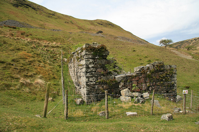
The pumping wheelpit stands to nearly its full height, as a photograph of 2009 shows.
The wheelpit of the 52-foot wheel, a stone-lined bob pit at the shaft head, the horse whim circle, a small crusher house with its own wheelpit, ore bins, a paved floor with slab-lined troughs that probably held jigs, leats, trackways, and a long office range of three rooms by the stream.
Nearby mines
- Nant y Car South Mine — 0.1 miles (0.2 km) NE
- Nant-y-Garw Lead Mine — 0.7 miles (1.1 km) W
- Nant y Car North Mine — 0.8 miles (1.4 km) NE
- Cwm Elan Mine — 2.9 miles (4.7 km) N
- Nantybrain Mine — 7.2 miles (11.5 km) SW
Straight-line distance, within 9 miles (15 km). Show on the map.
Further reading
The archaeological trust's field survey of 1992-93: the shaft, adit, wheelpits, crusher house, dressing floor and office.
View sourceA local history page giving the mine's early years from 1850, with photographs of the wheelpit, shaft and manager's house.
View sourceSources
- (secondary) The history of Dalrhiw Mine — Elan Valley Past and Present
- (secondary) Powys Metal Mines Survey: Dalrhiw (HER 5511) — Clwyd-Powys Archaeological Trust, Powys Metal Mines Survey
- (primary) Dalrhiw Lead Mine (NPRN 275635) — Coflein, Royal Commission on the Ancient and Historical Monuments of Wales
- (primary) Scheduled Monument BR231: Dalrhiw Lead Mine — Cadw
- (secondary) Historic Landscape Characterisation, The Elan Valley: Dalrhiw (HLCA 1135) — Clwyd-Powys Archaeological Trust
- (observational) Pumping wheelpit, Dalrhiw mine (Geograph photograph 1319278, 2009) — Geograph
Record created: 18 November 2026 · Last researched: 18 November 2026