 MineArchive
Middlecleugh Mine
| Also known as | Middle Cleugh Mine, Middlecleugh Upper Level |
|---|---|
| Location | Nenthead, Cumbria — 54.7787, -2.3298 (approximate) |
| Commodities | Lead, Zinc |
| Type | Metal |
| Worked | After 1758–By 1920 |
| Maximum depth | Unknown. |
| Operators | London Lead Company (1758–1882), Nenthead and Tynedale Zinc Company (1882–1896), Vieille Montagne Zinc Company (1896–1920) |
Overview
A Nenthead level driven soon after 1758 near the meeting of the Middle Cleugh and Long Cleugh Burns, worked for lead by the London Lead Company and later fitted with hydraulic plant by the Vieille Montagne Zinc Company. Its entrance fell in during the late 1980s and was dug out again in 2006-07.
History
The Middlecleugh level was begun soon after 1758, the year the London Lead Company took out its Nenthead leases, and stands near the confluence of the Middle Cleugh and Long Cleugh Burns at the head of the Nent. Most of the level's development belongs to the London Lead Company's long tenure, which ran for more than a century until 1882. The workings reached the Middlecleugh North Vein, the Middlecleugh First and Second Sun Veins, the Caplecleugh and Longcleugh Veins and the Smallcleugh Cross Vein, and the level was driven mainly for ventilation rather than as a main haulage road, with small workings above it and sumps rising towards the ground above Smallcleugh.
From 1882 to 1896 the Nenthead mines passed to the Nenthead and Tynedale Lead and Zinc Company, and then to the Vieille Montagne Zinc Company, which turned the district from lead to zinc. Vieille Montagne put a hydraulic system into the Middlecleugh level: a large-diameter water pipe runs along the main drive, fed by a surface pipeline from Perry's Dam a kilometre to the south, and the company built a compressor house at the surface to hold water-driven air compressors. In 1943 Kingsley Dunham compiled longitudinal sections of the Middlecleugh veins for the Geological Survey from the two companies' own plans. Mining at Nenthead ended in 1920.
Geology
The Middlecleugh veins cut the Great Limestone and the beds beneath it on the Alston Block, part of the North Pennine orefield's mineralised ground. The level itself was driven through shale, which is why so many of its branch passages have run in while the main drive has stayed open.
Geological setting: Hydrothermal Deposits (historical documentary reference), Veins and Lodes (well documented example)
Workings
A level rather than a shaft mine, driven for ventilation, reaching the Middlecleugh North Vein, the Middlecleugh First and Second Sun Veins, the Caplecleugh and Longcleugh Veins and the Smallcleugh Cross Vein. Small workings lie above the level and several sumps rise towards the ground above Smallcleugh; an engine shaft stands on the Middlecleugh North Vein. Parts of the mine can also be reached from within Smallcleugh and from surface shafts. A large-diameter water pipe laid by the Vieille Montagne Zinc Company runs along the main drive to the junction with Longcleugh Vein and on down towards the Smallcleugh level.
Closure
Mining at Nenthead ceased in 1920, at the end of the Vieille Montagne Zinc Company's working of the district. No separate last working year is recorded for Middlecleugh itself.
What remains
The entrance collapsed in the late eighties. Between the summer of 2006 and the winter of 2007 the Cumbria Amenity Trust Mining History Society dug out the collapse and re-arched the beginning of the entrance passage, laying rail track which also served to bring out the debris. The main drive is open throughout; many branch passages remain collapsed. The workings hold miners' graffiti some two hundred and thirty years old and a rare surviving stretch of wooden tramway rail.
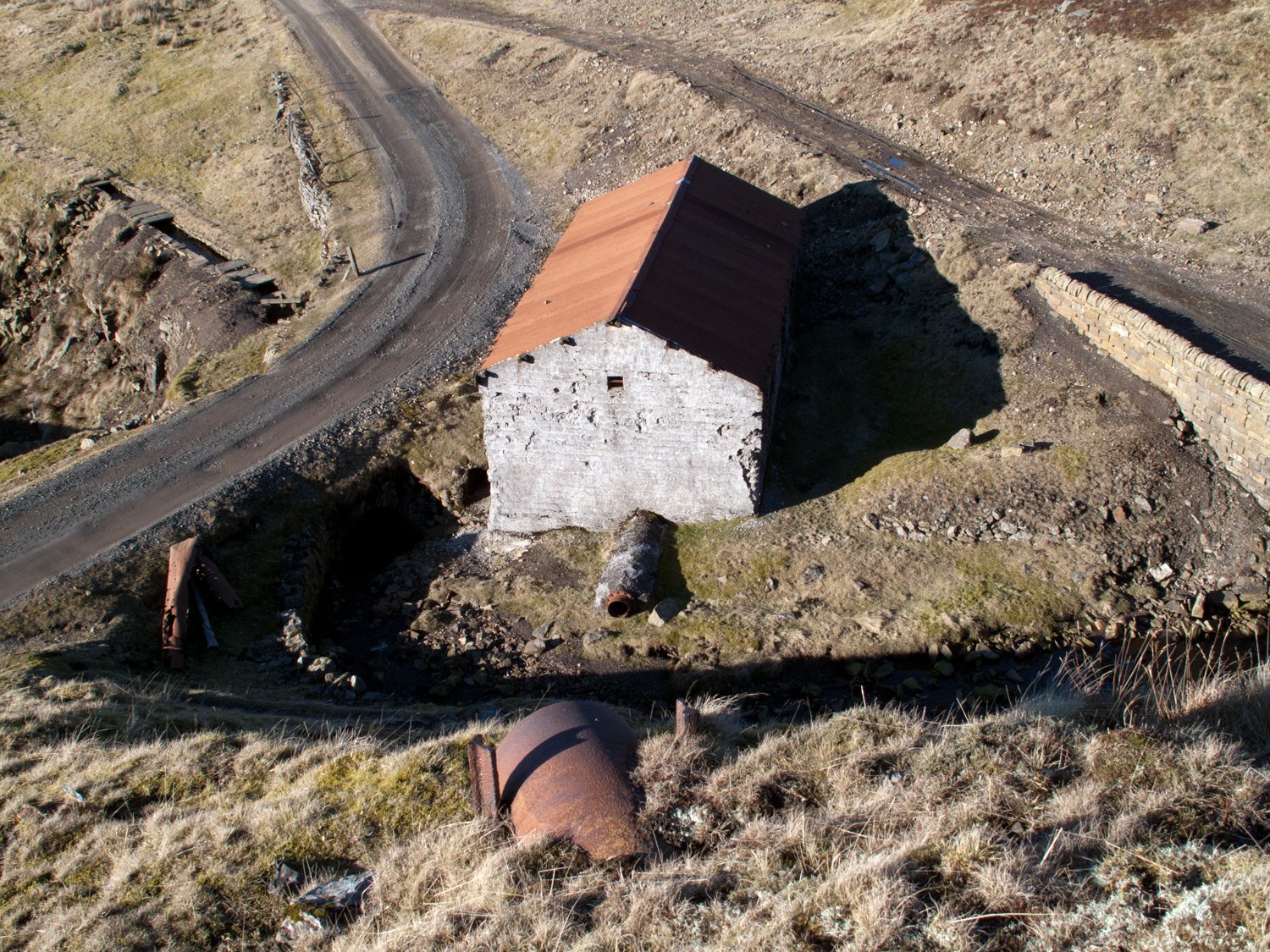
The Middlecleugh mine shop survives to eaves height on three sides to the north west of the buried portal, whose position is marked by the end of a roadway crossing the culverted Middle Cleugh Burn. The Vieille Montagne compressor house stands to the north at the meeting of the Nent and Old Carr Burns and is still roofed. A sample length of the pipeway from Perry's Dam survives on a spoil tip to the south, and a bridge west of the compressor house carries an unusual sluicing arrangement. A south powder store and the Middlecleugh bridge also survive; the 2018 condition survey recorded the rear wall of the mine shop and a side wall of the bridge as bulging.
Redevelopment
None. The site lies within the scheduled Nenthead lead mines, ore works and smeltmill, and the 700-hectare site is in public ownership.
Related mines
- Longcleugh Mine — The Middlecleugh level reaches the east side of Longcleugh Vein, and the Vieille Montagne water pipe runs to the junction of the two.
- Smallcleugh Mine — Middlecleugh's sumps rise towards workings above Smallcleugh, its Second Sun Vein sump connects with Mitchells Flat in Smallcleugh, and parts of Middlecleugh can be reached from within it.
Nearby mines
- Nentsbury Mine — 0.5 km N
- Carrs Mine — 0.6 km NW
- Rampgill Mine — 1.0 km N
- Longcleugh Mine — 1.1 km N
- Dowgang Mine — 1.2 km N
Straight-line distance, within 15 km. Show on the map.
Recorded claims
Individual factual claims, each attached to the source(s) that support it below. Where sources disagree, both are kept.
- The Middlecleugh level was begun soon after 1758 and lies near the confluence of the Middle Cleugh and Long Cleugh Burns. 1,2
- Much of the level's development was carried out by the London Lead Company, which took out its Nenthead leases in 1758 and worked the mines for more than a century until 1882. 3,2
- The level was driven primarily for ventilation, with small workings above it and multiple sumps presumed to rise to workings above Smallcleugh Mine. 2
- The main drive gives access to the east side of Longcleugh Vein, the east side of Middlecleugh North Vein and the Smallcleugh Cross Vein; an engine shaft stands on the Middlecleugh North Vein. 2
- From 1882 to 1896 the Nenthead mines were worked by the Nenthead and Tynedale Lead and Zinc Company, and afterwards by the Vieille Montagne Zinc Company. 3,2
- The Vieille Montagne Zinc Company installed part of a hydraulic system in the level; a large-diameter water pipe runs along the main drive to the Longcleugh Vein junction and on towards the Smallcleugh level. 2
- A building at the confluence of the Nent and Old Carr Burns, still roofed, was built by the Vieille Montagne Zinc Company to house a hydraulic compressor fed by a pipeway from Perry's Dam a kilometre to the south. 1
- The Middlecleugh mine shop survives to eaves height on three sides, north west of the now buried portal. 1
- The 2018 OREsome archaeological condition survey recorded the Middlecleugh mine shop and bridge in Area 1 of the Nenthead site, noting a bulging rear wall on the shop and a bulging side wall on the bridge. 4
- Kingsley Dunham drew and compiled longitudinal sections of the Middlecleugh North, Middlecleugh First and Second Sun, Caplecleugh and Longcleugh veins in 1943, based on plans and sections of the London Lead Company and the Vieille Montagne Zinc Company. 5
- The entrance collapsed in the late 1980s and was reopened between the summer of 2006 and the winter of 2007 by the Cumbria Amenity Trust Mining History Society, who dug out the collapse, re-arched the entrance passage and laid rail track. 2
- The workings contain miners' graffiti some 230 years old and a rare surviving example of wooden tramway rails. 2
- The level was driven through shale, and many of its branch passages are consequently collapsed while the main drive remains open. 2
Photographs & further reading
The society's directory entry, listing the published literature on the mine from Dunham 1948 to Lawson 2015 and the Lists of Mines and Mineral Statistics runs that cover it.
View sourceAn account of the level after its reopening, with separate reports on the Second Sun Vein and the Middlecleugh North Vein engine shaft.
View sourceSources
- (primary) Lead mines, ore works and smeltmill at Nenthead, Alston Moor — scheduled monument — Historic England (via Ancient Monuments)
- (observational) Middlecleugh Mine / Middlecleugh Upper Level, Nenthead, Cumbria — Mine Explorer Society
- (secondary) Middlecleugh Mine — Northern Mine Research Society
- (secondary) Nenthead Mines OREsome Summary Report, August 2018 — North Pennines National Landscape
- (primary) Middlecleugh Mine: longitudinal sections of the Middlecleugh, Caplecleugh and Longcleugh veins (SP2082) — British Geological Survey
Record created: 28 September 2026 · Last researched: 28 September 2026