 MineArchive
Langbaurgh Whinstone Mine
| Also known as | Langbaurgh Quarry, Langbaurgh Ridge Whinstone Quarries |
|---|---|
| Location | Great Ayton, North Yorkshire — 54.5019, -1.1402 (approximate) |
| Commodity | Whinstone |
| Type | Stone |
| Worked | From 1882–1950 |
| Maximum depth | Unknown. |
| Operators | Bradley Brothers (1882–1910), Gribdale Mining Company Ltd (1910–1920) |
Overview
A whinstone mine on Langbaurgh Ridge at Great Ayton, working the Cleveland Dyke — a wall of hard basaltic rock that runs some thirty miles across the North York Moors and gave the wapentake its name. Unusually for a stone working it was largely underground: of fifty-three employed at its peak in 1910, thirty were below ground. The Bradley family held it for most of its life, and it was still returning igneous rock in 1950.
History
The Cleveland Dyke runs for about thirty-one miles between Blea Hill Ridge near Robin Hood's Bay and Eaglescliffe, cutting through the surrounding sedimentary rocks as a nearly vertical wall of hard stone forced up from below some fifty-eight million years ago. Near Great Ayton it stands out as Cliff Ridge and Langbaurgh Ridge, the latter giving its name to the wapentake of Langbaurgh, and there the dyke is about eighty feet across at the surface — accessible enough to make an industry of.
What turned Great Ayton into an industrial village was the railway. A freight link between Battersby and Nunthorpe opened in 1864, built to bring Rosedale ironstone to Teesside by a shorter route, and it happened to pass close to the whinstone and ironstone workings around Ayton, which made moving stone a commercial proposition for the first time. The whinstone was wanted for roads, as hardcore and as setts and blocks for surfacing.
Langbaurgh appears in the returns from 1882 and stays in them, with one gap, for nearly seventy years. M. Bradley held it in the 1880s, Bradley Brothers in the 1890s, the Gribdale Mining Co. Ltd in the 1910s, George Bradley in the 1920s and Bradley Bros. again in the 1930s. Employment ran from eight in 1883 to a peak of fifty-three in 1910, fell away to nothing during the First World War when the working was not worked at all, and settled at ten to twenty between the wars. From 1922 the returns begin to call the product igneous rock rather than whinstone, and it is still listed in 1950. Two deaths are recorded: Isaac Storrow, a miner of fifty-three, struck on the head in 1892 when the teeth of a spur wheel broke while he sat in the engine house, and Frederick Davison, thirty-one, killed in 1903 by a piece of whinstone that fell from the roof fifteen feet above him.
Geology
The mine worked the Cleveland Dyke, a Palaeogene intrusion associated with the Mull volcanic centre in western Scotland, which travelled east as a near-vertical sheet of magma and solidified as a wall of basaltic andesite cutting the Jurassic sedimentary rocks of the moors. Locally the rock is called whinstone, and its hardness is the whole point of it: too hard to be a building stone, it made excellent roadstone, both as hardcore and dressed into setts. Where the dyke outcrops it has been quarried; at Langbaurgh it is about eighty feet wide at surface, which is what allowed it to be followed underground rather than merely stripped.
Geological setting: Faults and Fractures (well documented example)
Workings
Largely an underground working, which is what makes it a mine rather than a quarry in the returns: eighteen of twenty-two employed were below ground in 1894, twenty of twenty-five in 1900 and thirty of fifty-three in 1910, the split shifting to mostly surface work in the 1920s. The dyke was followed as a near-vertical wall. A tramway ran from the quarries along Langbaurgh Ridge down to a terminus beside the Middlesbrough to Whitby railway, whose sidings were still in use to serve the eastern end of the ridge in 1928.
Closure
The working was not worked at all in 1915 and came back after the war on a smaller scale. Igneous rock was still being returned from Langbaurgh in 1950; the closing date is not known. The quarries along the ridge were used as municipal landfill in the 1970s and have since been landscaped.
What remains
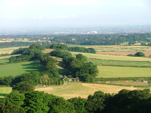
Langbaurgh Ridge survives as a wooded ridge running out from Great Ayton towards the Tees plain, its quarries filled and grassed: one of them was used for domestic refuse and the ridge has been landscaped since the 1970s. The former tramway terminus beside the railway is now occupied by industrial units.
The worked faces along the ridge, now landfilled and landscaped, and the site of the tramway terminus by the railway.
Redevelopment
The quarries along the ridge were used as municipal landfill in the 1970s and have since been landscaped; the tramway terminus site carries industrial units.
Related mines
- Cliff Rigg Quarry — Both were worked by the Gribdale Mining Company on the Cleveland Dyke, the same narrow intrusion of whinstone traced across the North York Moors — a shared operator working the same stone, not merely two quarries that happen to sit on one geological feature.
- Goathland Whinstone Mine — Both worked the Cleveland Dyke — the same named intrusion, followed underground for roadstone about thirty miles apart along its length, and both returned as whinstone and then as igneous rock in the same years.
- Sil Howe Whinstone Mine — Both worked the Cleveland Dyke, the same named intrusion, underground for roadstone — Langbaurgh at the western end at Great Ayton, Sil Howe near the eastern end above Goathland, some thirty miles apart along its length.
Nearby mines
- Cliff Rigg Quarry — 1.2 miles (1.9 km) SE
- Roseberry Mine — 1.6 miles (2.6 km) E
- Belmont Mine — 4.0 miles (6.4 km) E
- Eston Ironstone Mines — 4.0 miles (6.5 km) N
- Chaloner Ironstone Mine — 4.4 miles (7.0 km) NE
Straight-line distance, within 9 miles (15 km). Show on the map.
Recorded claims
Individual factual claims, each attached to the source(s) that support it below. Where sources disagree, both are kept.
- The dyke runs about thirty-one miles between Blea Hill Ridge near Robin Hood's Bay and Eaglescliffe, cutting the surrounding sedimentary rocks as a nearly vertical wall forced up from below about fifty-eight million years ago, and is about eighty feet across at the surface near Great Ayton. 1
- A freight-only rail link between Battersby and Nunthorpe opened in 1864, built to bring Rosedale ironstone to Teesside by a shorter route; it passed close to the workings around Great Ayton and made moving local whinstone and ironstone commercially viable. 1
- Most of the workforce was below ground: eighteen of twenty-two in 1894, twenty of twenty-five in 1900 and thirty of fifty-three at the 1910 peak. 2
- The workings passed from M. Bradley in the 1880s to Bradley Brothers in the 1890s, the Gribdale Mining Co. Ltd in the 1910s, George Bradley in the 1920s and Bradley Bros. in the 1930s. 2
- Two deaths are recorded: Isaac Storrow, 53, struck on the head in the engine house in 1892 when the teeth of a spur wheel broke, and Frederick Davison, 31, killed in 1903 by a piece of whinstone falling from the roof fifteen feet above him. 2
- The quarries along the ridge were used as municipal landfill in the 1970s and have since been landscaped. 1,3
- The 1888 List of Mines under the Metalliferous Mines Act gives 'Langbaurgh, Great Ayton, George Bradley, M. Bradley, Great Ayton, Northallerton (Yorks)', one of eight whinstone mines returned in the whole country that year, six of them on the Cleveland Dyke. 4
Photographs & further reading
Owners, output and employment returns from 1882 to 1950, with the below-ground and surface split that shows how much of the working was a mine, and the two recorded deaths.
View sourceHow the Cleveland Dyke runs across the moors, why the whinstone was worth working, and what the 1864 railway did for the industry at Great Ayton.
View sourceSources
- (secondary) Whinstone Mining — Great Ayton History Society
- (primary) Langbaurgh (Whinstone) — Durham Mining Museum
- (observational) Langbaurgh Ridge (photograph) — Geograph Britain and Ireland
- (primary) 1888 List of Mines under the Metalliferous Mines Act: Whinstone Mines — Mines Department, via the Durham Mining Museum
Record created: 4 September 2026 · Last researched: 4 September 2026