 MineArchive
Handsworth Colliery
| Also known as | Handsworth Nunnery Colliery |
|---|---|
| Location | Handsworth, east Sheffield (Finchwell Road), South Yorkshire — 53.3769, -1.3859 (approximate) |
| Commodity | Coal |
| Type | Coal |
| Worked | 1903–October 1967 |
| Maximum depth | Unknown. |
| Operators | Nunnery Colliery Co., Ltd. (1903–1947), National Coal Board (1947–1988) |
Overview
A Handsworth pit sunk in 1903 for the Nunnery Colliery Company, employing 1,472 by 1954, closed in 1967 and kept as a pumping station until 1988.
History
Handsworth Colliery, sometimes called Handsworth Nunnery, stood at Handsworth, three and a half miles east of Sheffield. Its pit was sunk in 1903 for the Nunnery Colliery Company, the Sheffield firm that also worked Nunnery Colliery at Darnall, and the Northern Mine Research Society's list records Handsworth Pit as part of Nunnery Colliery.
In 1923 the colliery employed 150 men in the Flockton seam and 485 in the Parkgate. Employment in the Parkgate rose to 971 in 1933, and in 1940 894 worked there with another 21 in the Furnace seam. The colliery passed to the National Coal Board in 1947; NMRS records it under the name High Hazels No. 2 in that year. By 1954 it employed 1,472, 1,131 of them underground, working the Flockton, Haigh Moor, High Hazels and Parkgate seams for coking, gas, household, manufacturing and steam coal.
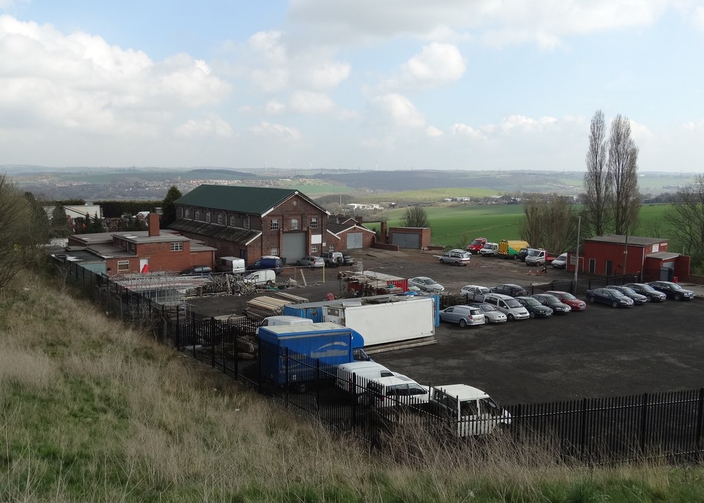
Production ended at the end of October 1967. The shaft was then used as a pumping station from 1971 to 1988. A colliery building still stands among business premises on Finchwell Road, in the yard where the pithead was.
Geology
South Yorkshire Coal Measures. The colliery worked the Flockton and Parkgate seams in 1923, the Furnace in 1940, and the Flockton, Haigh Moor, High Hazels and Parkgate by 1954.
Workings
A shaft colliery sunk in 1903 with its pithead in the yard off Finchwell Road. After closure it served as a pumping station from 1971 to 1988; plans of the Haigh Moor seam record an abandonment date of 1 August 1971.
Closure
Coal production ended at the end of October 1967. The shaft was used as a pumping station from 1971 to 1988.
What remains
A 2014 photograph shows a former colliery building standing among business premises on Finchwell Road, with the colliery's spoil heaps to one side largely hidden by vegetation.
A former colliery building on Finchwell Road and vegetated spoil heaps (2014).
Redevelopment
The pithead yard is occupied by business premises off Finchwell Road (2014).
Related mines
- High Hazels Colliery — Both Nunnery Colliery Company pits; Handsworth was returned as High Hazels No. 2 in 1947 before taking its own name in 1948.
- Nunnery Colliery — Both were worked by the Nunnery Colliery Company, and NMRS records Handsworth Pit as part of Nunnery Colliery.
Nearby mines
- High Hazels Colliery — 0.6 miles (0.9 km) N
- Orgreave Colliery — 0.9 miles (1.4 km) E
- Treeton Colliery — 1.8 miles (2.9 km) E
- Birley Collieries — 1.8 miles (3.0 km) SE
- Fence Colliery — 2.0 miles (3.2 km) E
Straight-line distance, within 9 miles (15 km). Show on the map.
What's uncertain
Points where sources disagree or the record could not be settled; both accounts are kept. All open questions in the archive.
- NMRS records the pit as High Hazels No. 2 in 1947, and High Hazels No. 3 Pit, sunk in 1901, as renamed Handsworth from 1948 to 1966. (uncertain) 1
Recorded claims
Individual factual claims, each attached to the source(s) that support it below. Where sources disagree, both are kept.
- Handsworth Pit was sunk in 1903, closed at the end of October 1967 and used as a pumping station from 1971 to 1988; it was part of Nunnery Colliery. 1
- NMRS records the pit as High Hazels No. 2 in 1947, and High Hazels No. 3 Pit, sunk in 1901, as renamed Handsworth from 1948 to 1966. (uncertain) 1
- In 1933 the colliery employed 971 in the Parkgate seam, and in 1940 894 in the Parkgate and 21 in the Furnace. 2
- In 1954 Handsworth employed 1,472, 1,131 below ground, working the Flockton, Haigh Moor, High Hazels and Parkgate seams. 2
- Plans of the Haigh Moor seam at Handsworth record an abandonment date of 1 August 1971. 3
- A 2014 photograph shows a building that belonged to Handsworth Nunnery Colliery in the yard on Finchwell Road where the pithead stood, with vegetated spoil heaps nearby. 4
Photographs & further reading
A 2014 photograph of the surviving colliery building in the former pithead yard.
View sourceOwners, employment by seam from 1923 to 1954, and output types.
View sourceSources
- (secondary) Coal Mines in Yorkshire 1854 onwards (H) - Northern Mine Research Society — Northern Mine Research Society
- (primary) Durham Mining Museum - Handsworth Colliery (UK) — Durham Mining Museum
- (primary) BGS mine plans: Handsworth (Haigh Moor, abandoned 1 Aug 1971) — British Geological Survey / Mining Remediation Authority
- (observational) Business premises, Finchwell Road, Handsworth (Geograph, Neil Theasby, 2014) — Geograph
Record created: 1 October 2026 · Last researched: 1 October 2026