 MineArchive
Flinty Fell Lead Rakes
| Location | Flinty Fell, between Garrigill and Nenthead, Alston Moor, Cumbria — 54.7731, -2.3761 (approximate) |
|---|---|
| Commodity | Lead |
| Type | Metal |
| Worked | Later Norman–Early 19th century |
| Maximum depth | Unknown. |
| Operators | London Lead Company (1706–?) |
Overview
Lead rakes on Flinty Fell above Alston Moor: lines of shafts and shallow surface workings along the Brown Gill veins, worked from at least the later Norman period and on and off until the early 19th century. In the 12th century these were part of the Mines of Carlisle, whose silver-rich lead went to the royal mint at Carlisle, and the first documentary reference to mining here is from 1130. Three stretches of the rakes are scheduled, taking in a whimsey shaft mound forty metres across and Longholehead, whose shaft is still open under concrete railway sleepers.
History
The first documentary reference to mining around Alston is from 1130, and in the medieval period these were mines of national importance, part of the Mines of Carlisle. The lead ore raised in the middle of the 12th century is thought to have been especially rich in silver and was used at the royal mint at Carlisle. Lead is thought to have been worked from the Brown Gill and Brown Gill Sun veins from at least the later Norman period, intermittently, until the early 19th century, by which time most of the work was being done from adits driven in from Garrigill Burn to the west and from Nenthead to the north. From 1706 the mining was controlled by the London Lead Company, which tended to work the veins at depth by adit. Longholehead Whimsey, the largest shaft in the scheduled ground, is thought to have been sunk by that company; it stands above the point where the underground workings of Whitesike Mine, two kilometres west, meet those driven from Nenthead, a kilometre and a half to the north-east. The rakes were scheduled on 23 December 1997 as three separate areas, chosen as the most distinct concentrations of well preserved earthworks within a much wider mining landscape.
Geology
The workings follow two associated east-west veins and the Brown Gill vein, in the lead field of the northern Pennines. A rake is the surface expression of a vein where the shallow ore has been taken out along its outcrop; here the rakes run as lines of shafts and shallow surface workings with spreads of ore-processing waste between them, extending from the top of Flinty Fell down to the 19th-century mines alongside Garrigill Burn.
Geological setting: Veins and Lodes (well documented example)
Workings
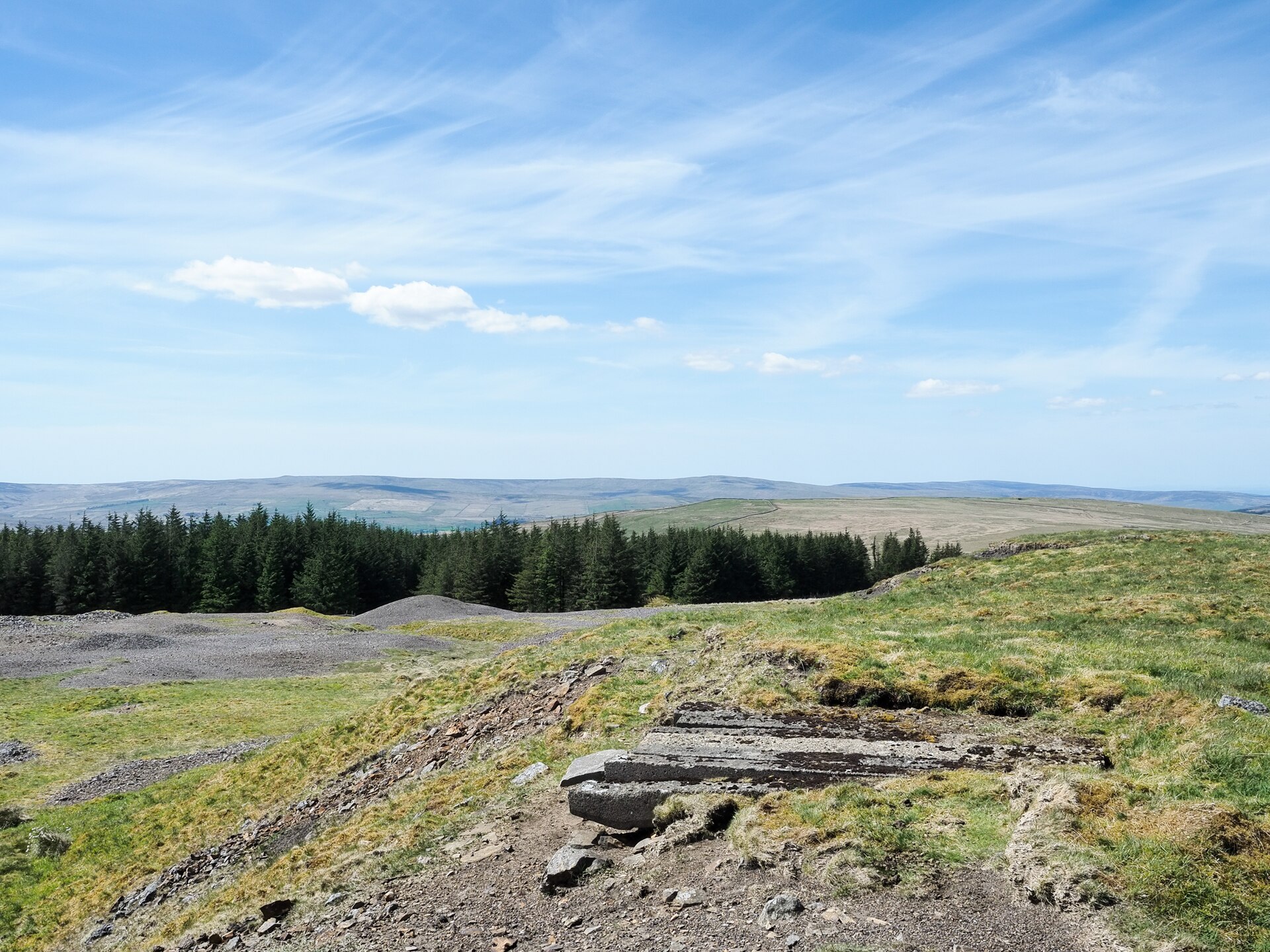
Rakes, shafts, levels and spreads of ore-processing waste. In the first scheduled area a whimsey shaft survives as a flat-topped mound of spoil some forty metres across and up to three metres high beside Souther Gill, with a depression marking the shaft itself and a level platform beside it where a horse walked a circle to turn the winding drum. Smaller shaft mounds about twenty metres across and a metre to a metre and a half high stand around it, some keeping their gin circles: in most of these the horse's track is concentric with the shaft rather than set to one side, the mark of a cog and rung gin, thought generally earlier than the whim gin. One shaft retains a drystone beehive capping half a metre high. The second area follows the Brown Gill vein and includes Longholehead Whimsey, whose mound is lower and whose shaft is still open, roughly capped with concrete railway sleepers. The third lies either side of Brown Gill stream, with shallow surface workings and hollows up to a metre deep. Spreads of hand-dressing waste cover most of the ground and hold the evidence of how the ore was crushed and sorted before it went to be smelted.
Closure
Working on these veins was intermittent and had largely gone underground by the early 19th century, most of it then being done from adits driven in from Garrigill Burn and from Nenthead. The rakes themselves were left as they stand.
What remains
Earthworks on open fell, scheduled since 1997 and well preserved. Longholehead's shaft is still open beneath its concrete sleepers. Remains inside the conifer plantation to the east were ploughed before planting and were left out of the scheduling, as were dressing wastes north of the road that have been partly reworked. Flinty Quarry, a working roadstone quarry, lies 800 metres to the south-east.
The whimsey shaft mound by Souther Gill with its gin platform, smaller shaft mounds with cog and rung gin circles, one shaft with a drystone beehive capping, Longholehead's open shaft under railway sleepers, shallow workings either side of Brown Gill, and extensive spreads of hand-dressing waste.
Redevelopment
None. The rakes lie on open fell; drystone walls and modern fences crossing them are excluded from the scheduling, though the ground beneath them is included.
Related mines
- Nenthead Mines — The workings driven from Nenthead run under Flinty Fell and meet Whitesike's beneath Longholehead Whimsey; by the early 19th century most of the working on these veins was being done from the Nenthead and Garrigill Burn adits.
- Whitesike Mine — Longholehead Whimsey on these rakes stands above the point where Whitesike's underground workings, two kilometres to the west, meet those driven from Nenthead, and both were London Lead Company ground.
Nearby mines
- Bentyfield Mine — 0.4 km NW
- Whitesike Mine — 0.6 km NW
- Coalcleugh — 1.7 km S, Northumberland
- Caplecleugh Mine — 2.1 km NE
- Smallcleugh Mine — 2.5 km NE
Straight-line distance, within 15 km. Show on the map.
Recorded claims
Individual factual claims, each attached to the source(s) that support it below. Where sources disagree, both are kept.
- The first documentary reference to mining in the area is from 1130, and the silver-rich ore raised in the mid-12th century was used at the royal mint at Carlisle. 1
- Lead was worked from the Brown Gill and Brown Gill Sun veins from at least the later Norman period, intermittently, until the early 19th century. 1
- From 1706 the mining was controlled by the London Lead Company. 1
- Scheduled on 23 December 1997, in three separate areas. 1
- Longholehead Whimsey's shaft remains open, roughly capped with concrete railway sleepers, above the junction of Whitesike Mine's workings with those driven from Nenthead. 1
- Most of the smaller shaft mounds keep gin circles whose horse track is concentric with the shaft, the mark of a cog and rung gin. 1
- The British Geological Survey holds a map showing the veins near Flinty Fell. 2
- Mounds of mine spoil with concrete railway sleepers embedded in them stand on the fell close to the Garrigill to Nenthead road. 3
Photographs & further reading
Historic England's account of the three protected areas, the shaft mounds and gin circles, and the documentary history from 1130.
View sourceSources
- (primary) Lead rake workings on Flinty Fell, 800m north west of Flinty Quarry, Alston Moor: scheduled monument 1017448 — Historic England, via AncientMonuments.uk
- (primary) Map showing veins near Flinty Fell (MP23704) — British Geological Survey
- (observational) Mine spoil and railway sleepers on Flinty Fell (photograph, 2020) — Geograph Britain and Ireland
Record created: 22 September 2026 · Last researched: 24 September 2026