 MineArchive
Felling Colliery
| Also known as | Brandling Main, John Pit (Felling) |
|---|---|
| Location | Felling, Gateshead, Tyne and Wear — 54.9553, -1.5706 (approximate) |
| Commodity | Coal |
| Type | Coal |
| Worked | 1779–1931 |
| Maximum depth | Upcast shaft 756 ft (230 m); Hutton seam at 101 fathoms |
| Operators | Charles Brandling (1779–?), Brandling Brothers (1800–1850), Carr, Potts & Co. (1850–?), Carr and Co. (1855–1860), Sir George Elliot (1880–1883), John Bowes & Partners Ltd (1883–1931) |
Overview
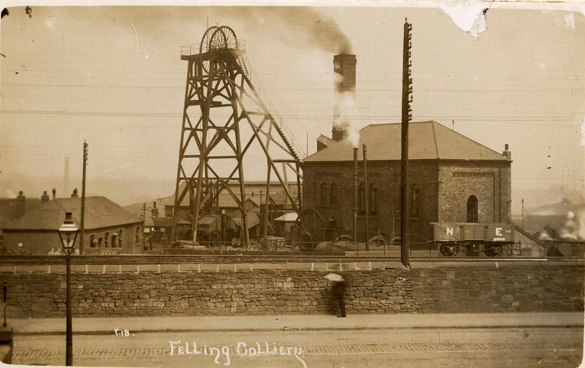
One of the oldest collieries in County Durham, sunk at Felling between Gateshead and Jarrow and known through much of its life as Brandling Main after the family that opened it. Coal had been wrought in Felling Manor since the seventeenth century; boring began in 1758 and the main pit was won to the High Main seam in 1779. It is remembered above all for the explosion of 25 May 1812, which killed 92 men and boys and, through the pamphlet the local clergyman wrote about it, led directly to the founding of the Sunderland Society and to the invention of the miners' safety lamp. The colliery worked on for well over a century after that, closing in 1931.
History
Felling had been a possession of the Brandlings of Gosforth since about 1590, and coal was wrought in Felling Manor as early as the seventeenth century. Boring operations began in 1758 and Charles Brandling opened the main pit in 1779, winning the High Main seam. Three shafts served the colliery: John Pit, the downcast and main access shaft; William Pit, the upcast, with a ventilation furnace burning at its foot; and Venture Pit. The High Main was worked out and abandoned on 19 January 1811. Shortly before it was exhausted the pit was deepened to the Low Main, which came into production in May 1811, a year before the disaster. The Bensham or Maudlin and the Hutton seams were won afterwards, and the Beaumont and Six Quarter later still.
The colliery passed out of Brandling hands in the middle of the nineteenth century, to Carr, Potts & Co. and then Carr & Co. in the 1850s, to Elliott & Co. in the 1860s, to Sir George Elliot in the 1880s and finally, in 1883, to John Bowes & Partners Ltd. Water was a standing problem across the whole group of Tyne collieries: when the High Main was abandoned and tubbed off at neighbouring Tyne Main in 1842, the owners of Felling, Walker, Wallsend, Willington and Heaton collieries agreed jointly to fund the large pumping engine at Friar's Goose to keep water out of the dip. By 1849 that one engine was raising 1,170 gallons a minute.
Whellan records 685 men and boys at the colliery in 1894, raising about 720 tons a day of gas and household coal. Employment climbed past 900 in the years before the First World War and peaked at 986 in 1921 before falling away. Winding stopped in 1931; the Maudlin or Bensham seam was abandoned that October, the Beaumont, Low Main, Hutton and Busty in December 1933, and the last of the High Main and Low Main workings in 1934. Four explosions killed men here in the nineteenth century — 1812, 1813, 1821 and 1847 — the first of them among the most consequential in British mining (see Disasters, below).
Geology
Felling stands on the concealed part of the Durham coalfield, working the normal Northumberland and Durham succession of Coal Measures seams one below another: High Main at the top, then Bensham or Maudlin in two sections at 76 and 88 fathoms averaging 2 ft 9 in, Low Main at 94 fathoms and 3 ft thick, Hutton at 101 fathoms and 5 ft thick, and the Beaumont and Six Quarter below. Water standing in the abandoned upper workings of neighbouring collieries was the controlling problem of the district rather than the coal itself.
Geological setting: Sedimentary Beds and Seams (well documented example)
Workings
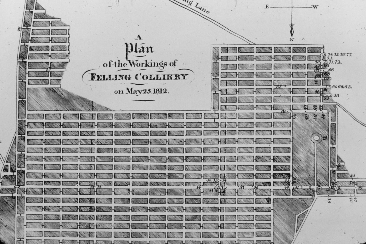
From the shaft bottoms a set of headings was driven, with stentings between them, and the coal taken in boards separated by walls. Ventilation depended on the furnace at the foot of William Pit, whose rising hot air drew fresh air down John Pit and round the workings; the circuit was directed by brick and timber stoppings, some pierced by openings that were closed by trap doors when not in use. The upcast shaft was 756 ft deep and 8 ft 8 in across, the downcast 606 ft and 7 ft 10 in. Before the safety lamp the only practical light was a candle, and where gas was suspected a Spedding mill was used instead, a steel cylinder spun against flint to throw a shower of sparks.
Closure
Coal winding at Felling ended in 1931 after a century and a half. The seams were formally abandoned over the following three years, the last of them in 1934.
What remains
The colliery site has been redeveloped and little of the surface plant survives. The brick round tower housing the John Pit air shaft still stands among trees beside Felling Metro station, where it was photographed in 2010. The dead of 1812 lie in a common trench in St Mary's churchyard at Heworth, under an obelisk carrying their names.
The brick round tower over the John Pit air shaft still stands among trees beside Felling Metro station; little else of the surface plant survives.
Related mines
- Hebburn Colliery — Both were Tyneside pits of the same group whose upper workings drained into one another; Felling is named on the Hebburn record for that reason.
- Nettlesworth Colliery — Collieries of Sir George Elliot.
- Penshaw Colliery — Collieries held by Sir George Elliot, who worked Penshaw from the 1860s.
- Shipcote Colliery — Old Shipcote workings were taken into the plans of Felling Colliery's John pit, and Shipcote's plans were held at Felling by John Bowes & Partners.
- Tyne Main Colliery — Felling's owners shared the cost of Tyne Main's Friar's Goose pumping engine from 1842.
- Usworth Colliery — Collieries of Sir George Elliot.
- Walker Colliery — From 1842 both collieries' owners shared the cost of the Friar's Goose pumping engine to keep water from reaching the dip workings.
Nearby mines
- Tyne Main Colliery — 0.5 miles (0.7 km) N
- St Anthony's Colliery — 0.8 miles (1.2 km) NE
- Deckham Hall Colliery — 1.0 miles (1.6 km) W
- Shipcote Colliery — 1.1 miles (1.7 km) W
- St Lawrence Colliery — 1.1 miles (1.8 km) NW
Straight-line distance, within 9 miles (15 km). Show on the map.
Disasters & major incidents
-
Felling Colliery explosion, 1812
25 May 1812 · Explosion · 92 fatalities
At about half past eleven on the morning of Monday 25 May 1812 a firedamp explosion tore through Felling Colliery near Gateshead, killing 92 men and boys of the 128 below ground. The ground shook for half a mile and the report was heard four miles off. Thirty-three men were brought out alive by a horse-whim worked by hand, three of whom later died; everyone else was left below. A second explosion drove back the one rescue party that got down, and the pit was sealed for six weeks to smother the fire. Recovery of the bodies took from July to September. The local curate's pamphlet on the disaster helped found the Sunderland Society, out of which came the Geordie and Davy safety lamps. -
Felling Colliery explosion, 1813
24 December 1813 · Explosion · 22 fatalities
At half past one on the morning of 24 December 1813 firedamp exploded again at Felling Colliery, killing nine men and thirteen boys and twelve horses, all of them in the headways near William Pit, the upcast. Those working in the boards away from it survived. The gas was supposed to have fired at the crane lamp, though other causes were suggested, and a week later fire was found in the waste and the shafts were stopped up again. -
Felling Colliery explosion, 1821
23 October 1821 · Explosion · 6 fatalities
On 23 October 1821 an explosion at Felling Colliery near Gateshead killed six. It was the third of the colliery's four nineteenth-century disasters, and by far the least recorded: only the date and the number of dead survive, with no names, cause or inquest. -
Felling Colliery explosion, 1847
22 June 1847 · Explosion · 6 fatalities
Shortly after nine on the evening of 22 June 1847 an explosion at Felling Colliery killed six miners, four outright and two from their injuries, and eighteen horses. It began not in the coal but at an underground haulage engine, whose fire had been banked with the damper shut so that it made gas like a retort. The jury found accidental death and asked for the damper to be pinned open. -
Felling Colliery breathing apparatus accident, 1911
31 October 1911 · Gas / Asphyxiation · 2 fatalities
Two men exploring unventilated old workings at Felling Colliery in Draeger breathing apparatus on 31 October 1911 were suffocated, one after collapsing and the other while going for help; the colliery surveyor got out.
Culture
- Felling Colliery disaster memorial, Heworth (Art)
The obelisk marks the common grave of the 91 recovered dead of the Felling Colliery explosion of 25 May 1812. - John Hodgson's Account of the Explosion at Felling (Literature)
Hodgson's Account describes the 1812 Felling explosion, with a plan of the workings.
What's uncertain
Points where sources disagree or the record could not be settled; both accounts are kept. All open questions in the archive.
- The Bensham or Maudlin was worked in two sections at 76 and 88 fathoms, the Low Main at 94 fathoms and the Hutton at 101 fathoms. A Victorian account also gives the 1779 sinking to the High Main as 127 fathoms, which cannot be right for the shallowest seam; it matches the 756 ft upcast shaft instead, and is most likely the shaft depth mis-attributed. (uncertain) 1
Recorded claims
Individual factual claims, each attached to the source(s) that support it below. Where sources disagree, both are kept.
- Boring at Felling began in 1758 and the main pit was opened to the High Main seam in 1779 by Charles Brandling. 1,2
- The colliery closed in 1931; its seams were formally abandoned between October 1931 and 1934. 1,2
- Whellan reports 685 men and boys at Felling in 1894, with a daily output of about 720 tons; employment peaked at 986 in 1921. 1,2
- The Bensham or Maudlin was worked in two sections at 76 and 88 fathoms, the Low Main at 94 fathoms and the Hutton at 101 fathoms. A Victorian account also gives the 1779 sinking to the High Main as 127 fathoms, which cannot be right for the shallowest seam; it matches the 756 ft upcast shaft instead, and is most likely the shaft depth mis-attributed. (uncertain) 1
- The brick round tower over the John Pit air shaft still stands in trees beside Felling Metro station. 3
- The BGS mine-plans catalogue holds a Mining Remediation Authority abandonment plan titled 'Felling' (catalogue 10456, Six Quarter, dated 1931). 4
Photographs & further reading
The full owner, seam, output and employment tables for the colliery, with dated maps from 1807 onwards and the list of those killed in each explosion.
View sourceSources
- (primary) Felling Colliery — Durham Mining Museum
- (primary) Felling Colliery (Brandling Main/John Pit), HER 3801 — Tyne and Wear Historic Environment Record
- (observational) Felling Metro Station, with the John Pit air shaft tower — Geograph Britain and Ireland
- (primary) BGS / Mining Remediation Authority mine plans: FELLING — British Geological Survey / Mining Remediation Authority
Record created: 9 September 2026 · Last researched: 9 September 2026