 MineArchive
Dyfngwm Mine
| Also known as | Dyfngwm and Castle Rock Mine, Castle Rock Mine, Dyngwm Mine |
|---|---|
| Location | Gorge of the Afon Clywedog, about a mile south-south-west of Dylife, Llanbrynmair, Powys — 52.5236, -3.6978 (exact) |
| Commodities | Lead, Copper, Zinc |
| Type | Metal |
| Worked | By 1842–1935 |
| Maximum depth | About 40 fathoms below the deep adit (about 73 m) |
| Operators | Hirnant Minerals Ltd (?–1935) — Built the processing mill of 1935 beside the Clywedog; work ended that year. |
Dyfngwm, also called Castle Rock, was a lead, zinc and copper mine in the gorge of the upper Clywedog, a mile south-south-west of Dylife in western Montgomeryshire. It worked the southern branch of the Dylife lode. Old opencuts and hushing channels on the hill above may go back to Roman times; the recorded mine ran from the 1840s to 1870, returning 4,930 tons of lead ore, and was reopened before closing for good in 1935.
Location
Recorded location. The large pin is this mine; the small round markers are the nearest mines on record. Click one for its page. View on full map
History
The hill between Dyfngwm and Dylife is scored with opencuts, shallow shafts and run-in levels that are clearly old, and with channels and small dams that look like hushing, the scouring of a hillside with released water to expose a vein. A Roman fortlet stands close by on the ridge, which has encouraged the view that mining here began in Roman times or before. Stone mortars for dressing ore by hand have been found buried in the tips of one old level.
The mine is on record by 1842. The first workings were from a shaft on the hilltop; later a deep adit was driven north into the lode from the side of the gorge. Lead ore was returned in 1845, 1847 to 1849 and every year from 1852 to 1870, with a best year of 541 tons in 1862. The total was 4,930 tons of lead ore, 10,356 ounces of silver and 134 tons of copper ore.
Machinery came thick and fast, and the mine has a name for mismanagement. Two waterwheels, stamps and a drawing machine went in during 1850, a steam engine to drive the pump rods in the adit in 1856, a 36-inch condensing engine in 1858, and in 1864 a twin-cylinder horizontal engine and a steam traction engine that probably saw little use. A 60-inch Cornish pumping engine stood at Boundary shaft on the hilltop. Dyfngwm was among the first mines in Powys to use steam at all.
After 1870 the record is thin. The mine was reopened and yielded a good deal more lead, and in 1935 Hirnant Minerals Ltd built a mill by the river with an oil engine, crushers, jigs, a ball mill and concentrating tables. Work ended that year.
Geology
The Dyfngwm lode is the southern branch of the Dylife lode and strikes east-north-east. It carries galena, blende and a notable share of copper pyrites in quartz and calcite, with more blende at and below the adit than nearer surface. The workings lie in the lower part of the Frongoch formation, just east of an anticline that brings the Gwestyn shales up in the valley, and the bottom of the mine probably enters those shales. Castle Rock, in the gorge to the west, is probably one of the best natural exposures of a lode in Wales.
Geological setting: Veins and Lodes (well documented example)
Workings
The early mine was worked from a shaft 250 yards west of the Pen Dylife shaft on the same lode. The deep adit, at about 1,310 feet above sea level, runs north from the gorge to the lode and connects with Boundary shaft on the top of Pen Dylife; the shaft bottom is about 40 fathoms below the adit. Opencuts, shallow shafts and levels follow the Dylife and Dyfngwm lodes along the ridge for about a kilometre, and a quarry-like opencast lies near the mill. Tramways ran from the adit to inclines down to the dressing floors on the river bank, fed by a leat from the Clywedog.
Closure
Mining ended in 1935; the abandonment plan, for lead and zinc ores, is dated 1 June 1935.
What remains
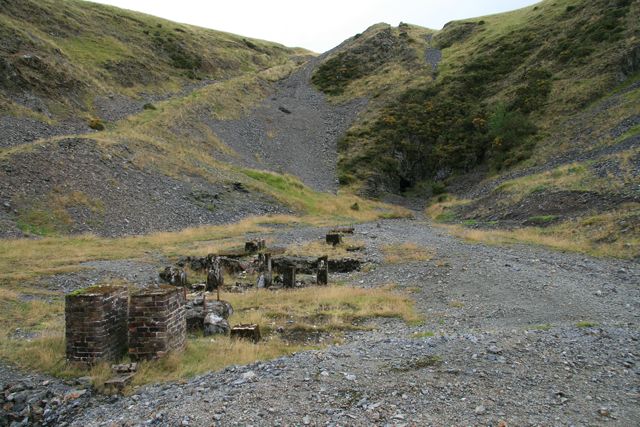
The mine is a scheduled monument. In the gorge the adit mouth, brick engine bases and wide fans of grey waste were all plain to see in 2008. The engine house at Boundary shaft has collapsed completely.
Two wheelpits and engine bases outside the adit; a ruined crusher house by the river; the concrete and flagstone foundations of the 1935 mill climbing the slope beside it; a line of seven slime pits along the south bank; whim circles, the base of an incline drum and a large square earthwork enclosure by the hilltop shafts; and at Boundary shaft the engine reservoir and the iron gudgeon of the balance bob.
Related mines
- Cyfarthfa Mine — Cyfarthfa stands on the western end of the Dyfngwm lode, and the large dam beside it is said to have supplied water to Dyfngwm.
- Dylife — Dyfngwm works the southern branch of the Dylife lode, its deep adit connects with Boundary shaft beside the Pen Dylife workings, and a winding wheel put up at Dylife in 1861 may have drawn from that shaft.
Nearby mines
- Cyfarthfa Mine — 0.9 miles (1.5 km) W
- Dylife — 2.0 miles (3.2 km) NW
- Brynyfedwen Mine — 2.5 miles (4.0 km) N
- Rhoswydol Mine — 2.7 miles (4.3 km) N
- Ceulan Mine — 2.8 miles (4.5 km) N
Straight-line distance, within 9 miles (15 km). Show on the map.
Further reading
The Royal Commission's site record, with aerial photographs of the workings on the ridge and in the gorge.
View sourceThe archaeological trust's field survey of 1992-93, listing each working, engine and dressing-floor feature with its grid reference.
View sourceSources
- (primary) Dyfngwm Lead Mine (NPRN 309783) — Coflein, Royal Commission on the Ancient and Historical Monuments of Wales
- (primary) Lead and Zinc: The Mining District of North Cardiganshire and West Montgomeryshire (Special Reports on the Mineral Resources of Great Britain, vol. XX), O. T. Jones, 1922 — Memoirs of the Geological Survey
- (secondary) Powys Metal Mines Survey: Dyfngwm (HER 5942) — Clwyd-Powys Archaeological Trust, Powys Metal Mines Survey
- (primary) Scheduled Monument MG247: Dyngwm/Castle Rock Lead Mine — Cadw
- (secondary) Powys Metal Mines Survey: introduction — Clwyd-Powys Archaeological Trust, Powys Metal Mines Survey
- (secondary) Historic Landscape Characterisation, Clywedog Valley: Dylife — Clwyd-Powys Archaeological Trust
- (primary) Abandonment plan: Dyfngwm, lead and zinc ores, 1 June 1935 (OM11898) — British Geological Survey
- (observational) Dyfngwm Lead Mine (Geograph photograph 936006, 2008) — Geograph
Record created: 18 November 2026 · Last researched: 18 November 2026