 MineArchive
Cyfarthfa Mine
| Also known as | Nantddu Mine, Nant Ddu Mine, Cyfartha Mine |
|---|---|
| Location | Upper Clywedog valley, about a mile west of Dyfngwm, Cadfarch, Powys — 52.5230, -3.7199 (exact) |
| Commodities | Lead, Copper |
| Type | Metal |
| Worked | 1842–1881 |
Cyfarthfa, or Nantddu, was a small lead and copper mine at the western end of the Dyfngwm lode, about a mile west of Dyfngwm in the upper Clywedog valley. It was worked from 1842 to 1881 and returned just 99 tons of lead ore and 28 of copper ore. Its lode is wide and rich in blende, which was never raised. The pumping wheelpit, the crusher house and the tips survive.
Location
Recorded location. The large pin is this mine; the small round markers are the nearest mines on record. Click one for its page. View on full map
History
The mine dates from 1842. For most of its life it sold nothing that was recorded: the returns are for 1872 and for 1879 to 1881, and amount to 99 tons of lead ore, with 351 ounces of silver, and 28 tons of copper ore. Copper made up a large share of what the lode gave. Blende, which the lode holds in quantity, was apparently left in the ground.
It was laid out as a proper mine all the same. An engine shaft and a whim shaft were sunk through the Gwestyn shales, a single waterwheel pumped both through a split line of flat rods, a horse whim wound at the northern shaft, and a large wheel drove the crusher. Skip roads were supplied for the shafts in 1878, three years before the end. Work stopped in 1881.
Geology
The mine is on the western extremity of the Dyfngwm lode, which here, as elsewhere, dips north. The shaft passes through the rusty Gwestyn shales, about 150 yards west of their base. The lode is of great width and highly mineralised, rich in blende mixed with copper pyrites and associated with ferriferous dolomite and calcite, with galena beside them. It may do better at depth, where it enters the Van mudstones.
Geological setting: Veins and Lodes (well documented example)
Workings
A large engine shaft and a whim shaft stand about 100 yards north of the outcrop of the lode, with a deep adit, an air shaft to the east and a number of short, shallow trial levels that have let the surface down in places. Leats are everywhere: one from the Nant Ddu to the crusher, and another more than a kilometre long from the upper Nant Goch, which seems to have topped up the pumping wheel in dry weather. A large earth dam to the west is said to have supplied Dyfngwm, and probably this mine too.
Closure
The last return of ore is for 1881.
What remains
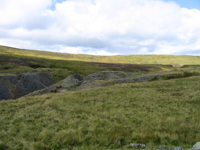
Spoil heaps and low ruins stood around the whim shaft on open moorland in 2007. Modern farm buildings have been built against the front of the crusher house and over most of the dressing floors.
A well-preserved pumping wheelpit and the gully of the flat rods to the northern shaft, an angle-bob pit at the engine shaft, the overgrown whim circle, the crusher house with its wheelpit and roll housing, skip roads still plain on the tips, ore bins and a picking floor by the whim shaft, slime tanks, the office range, and at the western edge a square stone building and a triangular banked enclosure whose purpose is not known.
Related mines
- Dyfngwm Mine — Cyfarthfa stands on the western end of the Dyfngwm lode, and the large dam beside it is said to have supplied water to Dyfngwm.
Nearby mines
- Dyfngwm Mine — 0.9 miles (1.5 km) E
- Dylife — 1.8 miles (2.8 km) N
- Rhoswydol Mine — 2.6 miles (4.2 km) N
- Brynyfedwen Mine — 2.8 miles (4.5 km) NE
- Cwmbyr Mine — 3.1 miles (5.0 km) W
Straight-line distance, within 9 miles (15 km). Show on the map.
Further reading
The archaeological trust's field survey of 1992-93, the fullest description of the shafts, leats, wheelpits and buildings.
View sourceSources
- (secondary) Powys Metal Mines Survey: Cyfartha, also known as Nant Ddu (HER 8497) — Clwyd-Powys Archaeological Trust, Powys Metal Mines Survey
- (primary) Lead and Zinc: The Mining District of North Cardiganshire and West Montgomeryshire (Special Reports on the Mineral Resources of Great Britain, vol. XX), O. T. Jones, 1922 — Memoirs of the Geological Survey
- (observational) Cafartha (also Nantddu) Mine (Geograph photograph 537016, 2007) — Geograph
- (primary) Abandonment plan: Cyfartha Silver Lead Mine, section (OM15062) — British Geological Survey
Record created: 18 November 2026 · Last researched: 18 November 2026