 MineArchive
Rhoswydol Mine
| Also known as | Rhoswydol and Bacheiddon Mine, Bacheiddon Mine |
|---|---|
| Location | Banc Rhoswydol, about 2 miles east of Aberhosan, Cadfarch, Powys — 52.5611, -3.7155 (exact) |
| Commodity | Lead |
| Type | Metal |
| Worked | 18th century–1877 |
Rhoswydol was a lead mine on Banc Rhoswydol, two miles east of Aberhosan and seven by road from Machynlleth, with a recorded life from 1845 to 1877. It is said to have been worked in the twelfth century and was certainly worked in the eighteenth. A rich find at Bwlch Coch nearby was worked with it as Bacheiddon in the late 1850s, and in 1870 a mill with Green's self-acting dressing machinery was built in the valley.
Location
Recorded location. The large pin is this mine; the small round markers are the nearest mines on record. Click one for its page. View on full map
History
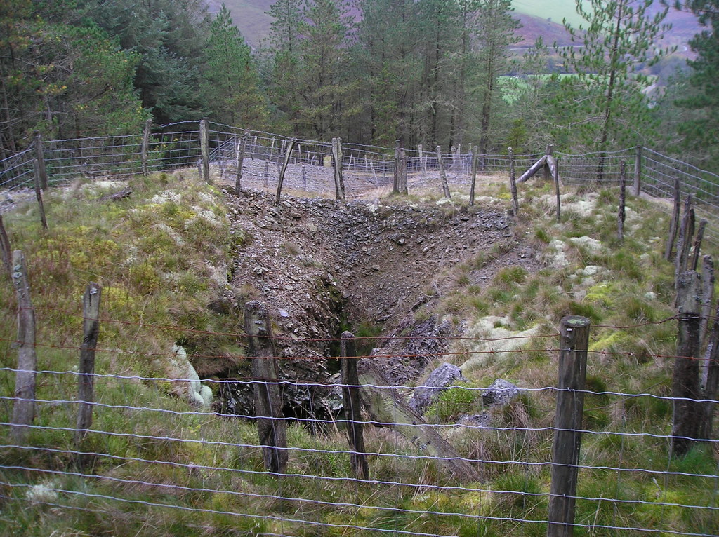
Old opencuts on the top of the hill, stoped through to daylight, are the remains of early work. The mine is said to go back to the twelfth century, and it was worked in the eighteenth.
Returns of lead ore begin in 1846 and run to 1863, then from 1868 to 1871 and from 1873 to 1877. Between 1855 and 1860 a separate discovery was worked alongside it under the name Bacheiddon: a lode at Bwlch Coch, beside the old road from Machynlleth to Llanidloes, that held a disc of ore about 50 fathoms long and is said to have been very rich. It was worked out in a few years, and a deep cross-cut driven under it later found the lode all but barren. A pumping engine house, the Bacheiddon Engine, was built in 1860 and pulled down soon afterwards. Bacheiddon probably gave about 1,000 tons of the ore credited to the mine.
In 1870 Green's Patent Self Acting Dressing Machinery was installed in a new mill in the valley, with crushing rolls, mechanical jiggers, buddles and classifiers driven by a 45-foot waterwheel. The returns end seven years later, although the 1880s are also given as a productive period.
Geology
Two parallel lodes strike west-south-west in Lower Silurian shales and mudstones, the main lode dipping south at 55 to 65 degrees and a north lode about 80 yards from it, with a nearly vertical cross-lode leaving the main lode west-north-west near the shaft. They carry galena, blende and barytes; the dumps on Banc Rhoswydol hold a good deal of blende, some in globular masses with a radiating fibrous structure. The Bacheiddon lode at Bwlch Coch runs west-north-west along the prevailing joints and is known nowhere else.
Geological setting: Veins and Lodes (well documented example)
Workings
The lode on Banc Rhoswydol was worked from several shallow adits and a shaft near the foot of the hill; at least ten shafts of different dates, four levels and two adits climb the hillside. From the valley by the dressing floors one adit, at about 650 feet above sea level, was driven east towards the main lode and another, at about 720 feet, on what is probably the north lode. Bacheiddon was worked from a cross-cut adit at about 1,000 feet and later a deep cross-cut at about 750 feet. A tramway ran from the main adit to Green's mill, and an incline joined the dressing floors to the upper workings. Three steam engines drove machinery on the upper floors and did some of the pumping and winding.
Closure
The last return of ore is for 1877.
What remains
The workings are partly under forestry. In 2012 a fenced hollow among the conifers marked where the stopes had followed the ore up to the surface.
The ruined walls of Green's mill of 1870, a very ruinous crushing mill outside Prosser's level, three ore bins at the Bacheiddon deep adit, short lengths of tramroad, the earthworks of the Bacheiddon engine house and the spoil dumps. The carpenters' shop, smiths' shop, count house and store sheds are poorly preserved.
Nearby mines
- Dylife — 0.9 miles (1.4 km) S
- Brynyfedwen Mine — 1.1 miles (1.7 km) E
- Ceulan Mine — 1.5 miles (2.4 km) E
- Llanerchyraur Mine — 1.9 miles (3.1 km) E
- Cae Conroy Mine — 2.4 miles (3.9 km) E
Straight-line distance, within 9 miles (15 km). Show on the map.
Further reading
The Royal Commission's site record for the workings and the dressing mill of 1870.
View sourceThe archaeological trust's field survey of 1992-93: shafts, adits, Green's mill and the Bacheiddon engine site, each with a grid reference.
View sourceSources
- (primary) Rhoswydol Lead Mine (NPRN 34012) — Coflein, Royal Commission on the Ancient and Historical Monuments of Wales
- (secondary) Powys Metal Mines Survey: Rhoswydol (HER 5940) — Clwyd-Powys Archaeological Trust, Powys Metal Mines Survey
- (primary) Lead and Zinc: The Mining District of North Cardiganshire and West Montgomeryshire (Special Reports on the Mineral Resources of Great Britain, vol. XX), O. T. Jones, 1922 — Memoirs of the Geological Survey
- (observational) Rhoswydol Lead Mine (Geograph photograph 2756431, 2012) — Geograph
- (primary) Mine plan: Rhoswydol or Bacheiddon Mine — British Geological Survey
Record created: 18 November 2026 · Last researched: 18 November 2026