 MineArchive
Ceulan Mine
| Location | Ceulan valley, about 2.5 miles north of Dylife, Llanbrynmair, Powys — 52.5625, -3.6802 (exact) |
|---|---|
| Commodities | Lead, Silver |
| Type | Metal |
| Worked | 17th century–1889 |
Ceulan was a lead mine in the Ceulan valley, a mile west of the Twymyn and two and a half miles north of Dylife, between the larger mines of Rhoswydol and Llanerchyraur. It worked three lodes, all better known from its neighbours, in the seventeenth century and again from 1857 to 1889. For all the ground it opened, with up to thirteen levels and three shafts, it returned only 260 tons of lead ore.
Location
Recorded location. The large pin is this mine; the small round markers are the nearest mines on record. Click one for its page. View on full map
History
There was mining here in the seventeenth century. The Victorian mine made its first return in 1857 and went on, with gaps, for thirty years: ore was sold in 1857 to 1859, 1861, 1862, 1864, 1870, 1872, 1874 and 1875, and every year from 1879 to 1888. The whole of it came to 260 tons of lead ore, giving 200 tons of lead and 706 ounces of silver.
The sett took in the Rhoswydol lode, the Graig Goch or Tyisaf lode and the eastward run of the Brynyfedwen lode, and each was tried in its turn: adits east and west on the first, an adit west on the second, a shaft on the third and another sunk to a fair depth between the first two. Two waterwheels did the pumping and crushing, the larger of them 40 feet across. Work stopped in 1889.
Geology
Three main lodes cross Silurian grits and mudstones at the base of the Frongoch formation: the Rhoswydol, the Graig Goch or Tyisaf, and the Brynyfedwen or south lode, about 600 yards south of the Graig Goch. The vein stuff is galena mixed with quartz and blende. In the valley by the southern workings the Gwestyn shales come up from beneath in the crest of an anticline.
Geological setting: Veins and Lodes (well documented example)
Workings
On the Rhoswydol lode an adit at about 900 feet above sea level was driven east and another, a little higher, west. A vertical shaft was sunk to a considerable depth midway between that lode and the Graig Goch lode, on which an adit at about 800 feet runs west, and the Brynyfedwen lode was reached by a shaft. The map of 1887 shows up to thirteen levels, three shafts, two adits and many trials, with stopes broken through to surface as long opencuts. A tramway ran from the northernmost shaft down to the crusher house, and inclines served the levels on the slopes of Llanerchyraur and Esgair Geulan.
Closure
The last return of ore is for 1888; work is dated to 1889.
What remains
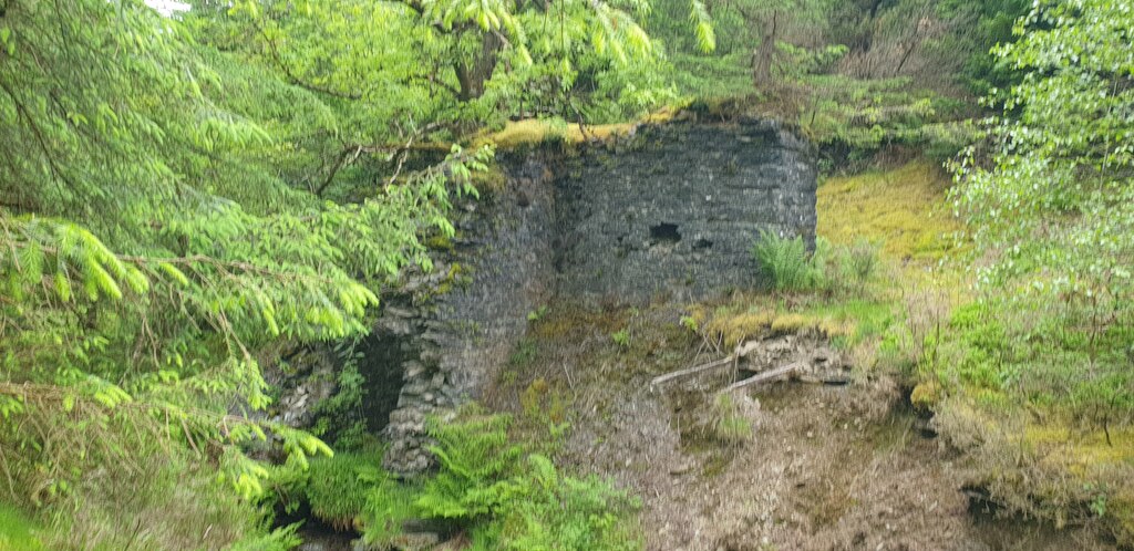
The workings are all still to be seen but lie under dense forestry. A roofless stone mine building, green with moss, stood among the conifers in 2022.
Two crusher houses, the sites of a 40-foot pumping and crushing wheel and a 30-foot pumping wheel, round buddles, an ore bin and washing floor, three settling tanks, and a range of buildings on the dressing floors that held the office and probably a smithy, stores and carpenter's shop.
Related mines
- Brynyfedwen Mine — Ceulan reached the eastward continuation of the main Brynyfedwen lode by a shaft and worked it within its own sett.
Nearby mines
- Brynyfedwen Mine — 0.5 miles (0.8 km) SW
- Llanerchyraur Mine — 0.6 miles (1.0 km) NE
- Cae Conroy Mine — 1.0 miles (1.6 km) E
- Rhoswydol Mine — 1.5 miles (2.4 km) W
- Dylife — 2.0 miles (3.2 km) SW
Straight-line distance, within 9 miles (15 km). Show on the map.
Further reading
The archaeological trust's field survey of 1992-93: the levels, shafts, tramways, wheels and dressing floors, each with a grid reference.
View sourceSources
- (secondary) Powys Metal Mines Survey: Ceulan mine (HER 8460) — Clwyd-Powys Archaeological Trust, Powys Metal Mines Survey
- (primary) Lead and Zinc: The Mining District of North Cardiganshire and West Montgomeryshire (Special Reports on the Mineral Resources of Great Britain, vol. XX), O. T. Jones, 1922 — Memoirs of the Geological Survey
- (observational) Mine building, Ceulan lead mine (Geograph photograph 7197259, 2022) — Geograph
Record created: 18 November 2026 · Last researched: 18 November 2026