 MineArchive
Devon United Mine
| Also known as | Devon United Mines, East Wheal Friendship, North Devon United Mine, Central Devon United Mine, South Devon United Mine, Wheal Anne, Mid Devon United Mine, South Devon United Mine Arsenic Works |
|---|---|
| Location | Cudliptown, Peter Tavy, Devon — 50.5964, -4.0911 (exact) |
| Commodities | Arsenic, Copper, Tin, Tungsten |
| Type | Metal |
| Worked | From about 1820–1923 |
| Maximum depth | South Devon United's Engine Shaft is said to be 50 fathoms, about 91 m; Central Devon United's shaft reached 26 fathoms below adit. |
| Operators | Contin Syndicate (?–1922) |
Overview
Three mines on the east bank of the Tavy under the western edge of Dartmoor — North, Central and South Devon United — worked from about 1820 for copper and later for tin and arsenic. Almost nothing is left above ground, but the dumps of the North mine are a geological Site of Special Scientific Interest and gave Britain its first recorded parkerite.
History
The Devon United mines lie on the south and east side of the River Tavy, strictly in the parish of Peter Tavy, half a mile east of Mary Tavy: North Devon United about 550 metres north of Cudliptown, Central Devon United about 550 metres south west of it, and South Devon United about 900 metres south west, east of the river.
North Devon United was also called East Wheal Friendship, and it began as a southern extension of one of Wheal Friendship's northern lodes. Work had started there before 1835, and in 1846 a London company took the property over; the sett was in two parts, 600 fathoms of it east of the river in Peter Tavy and a smaller 50-fathom piece to the west. About that time East Wheal Friendship was taken into the Devon United setts. Between 1846 and 1850 it returned 14,271 tons of copper ore from workings that consisted of an adit and two shafts on a lode said to average three metres wide.
South Devon United began separately as Wheal Anne in 1845 and closed in 1854. It sat on the Main South Lode and was worked from Engine Shaft, sixty-five metres from the river and said to be fifty fathoms deep, with an adit driven 290 fathoms east along the lode. Central Devon United worked a nearly vertical east-west lode called the Main Central from a shaft sunk near the river to twenty-six fathoms below adit.
The group started working copper about 1820 and was worked together with Wheal Friendship between 1842 and 1862 and again between 1882 and 1884. South Devon United reopened mainly for tin in 1904 and Central Devon United mainly for arsenic in 1909, and the two went on producing until 1922. The war of 1914 gave arsenic a push; the depression that followed closed the mines in 1923.
Their production is hard to pin down because the setts kept being amalgamated, with Wheal Friendship and at times with Wheal Jewell, so the returns run together. The figure usually given for the Devon United mines is 15,000 tons of copper ore, 1,500 tons of refined arsenic and 373 tons of tin concentrates.
Geology
The mines lie on the western side of the Dartmoor Granite, where the country rock is metamorphosed Carboniferous grits and shales — killas — heavily intruded by greenstones. All three worked east-west hydrothermal lodes of the main-stage mineralising event, at the boundary of the tin and copper zones: quartz and chlorite carrying arsenopyrite with cassiterite and bunches of chalcopyrite. The Main South Lode averaged nine metres wide in the last working; the Main Central was thirty to ninety centimetres.
What makes the small Mary Tavy and Peter Tavy field remarkable is how richly arsenopyrite developed alongside the copper ores. The Geological Conservation Review puts that on the same scale as Devon Great Consols and the Botallack area of Cornwall and nowhere else, and suggests the control is the presence of mafic intrusive rocks inside thermally metamorphosed sediments on the gently dipping flank of a granite. The same calcareous feldspars are the likely reason the tungsten here came up as scheelite rather than wolframite.
Geological setting: Veins and Lodes (well documented example)
Workings
North Devon United worked Bennetts Lode from an adit and two shafts. Central Devon United had a shaft near the river to twenty-six fathoms below adit, with the ten-fathom level running 140 fathoms and the twenty-six-fathom level ninety fathoms east of the shaft. South Devon United worked from Engine Shaft, said to be fifty fathoms deep, with adit level starting twenty-six fathoms west of the shaft and following the lode 290 fathoms east. A leat built to serve the mines still crosses the footpath from Horndon to the river.
Closure
The last working ended in 1922 and the mines closed in 1923, arsenic having been buoyed by the war of 1914 and then undone by the depression that followed. Wheal Friendship and the Devon United group were worked periodically until 1925.
What remains
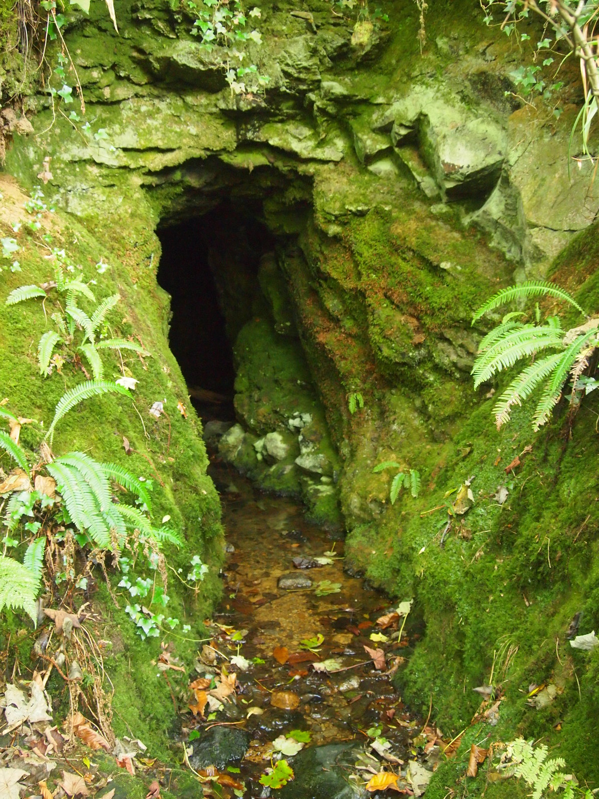
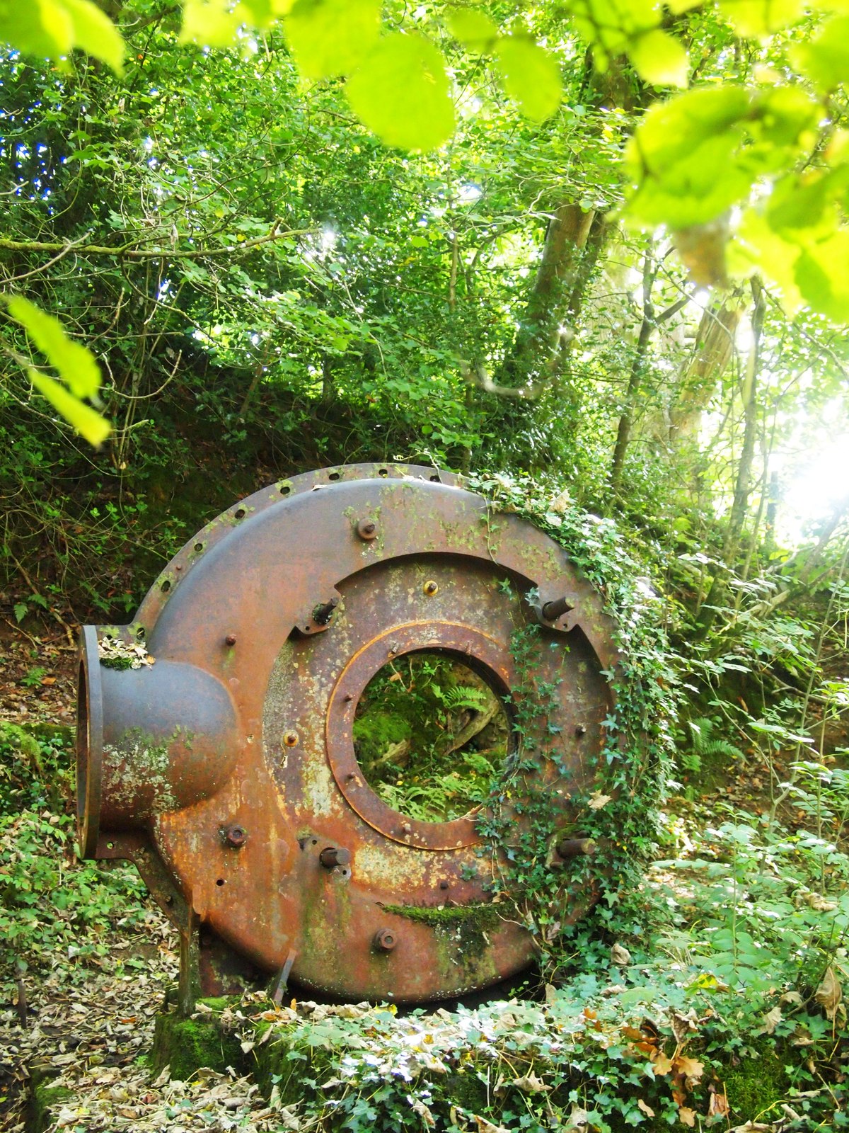
Virtually the entire infrastructure has long gone. What is left is dumps, overgrown, at several sites in the woods on the east bank of the river; an adit and the remains of a turbine can still be found. The dumps of the former North Devon United, in small woods near the river bank and the Horndon footbridge, are notified as a geological Site of Special Scientific Interest of 1.0 hectare, designated in 1987 and selected for the Geological Conservation Review.
Overgrown dumps in the woods on the east bank of the Tavy, an adit, the remains of a turbine, and the leat built to serve the mines.
Redevelopment
None: the ground is woodland and open moor edge, and part of it is an SSSI.
Related mines
- Devon Great Consols — The Geological Conservation Review names Devon Great Consols and the Botallack area as the only places where copper ores carry arsenopyrite on the scale seen at Devon United, and puts the same control behind all of them: mafic intrusives inside metamorphosed sediments on the flank of a granite.
- Wheal Betsy — The north-south cross-course that heaves the Wheal Friendship and Devon United lodes is believed to be the southerly extension of the Wheal Betsy structure, the lead lode proved for some 6.5 km at the north end of this orefield.
- Wheal Friendship — North Devon United began as East Wheal Friendship, a southern extension of one of Wheal Friendship's northern lodes, and the Devon United group was worked with Wheal Friendship between 1842 and 1862 and again between 1882 and 1884; the lodes are interconnected between the two banks of the Tavy and the setts share a common origin.
- Wheal Jewell — The Devon United setts were amalgamated at times with Wheal Jewell as well as with Wheal Friendship, which is one reason the production returns for all three run together.
Nearby mines
- Wheal Friendship — 1.0 miles (1.6 km) SW
- Wheal Jewell — 1.1 miles (1.8 km) W
- Merrivale Quarry — 3.1 miles (5.1 km) SE
- Wheal Betsy — 3.6 miles (5.8 km) SW
- Great and East Sortridge Consols — 4.5 miles (7.2 km) S
Straight-line distance, within 9 miles (15 km). Show on the map.
What's uncertain
Points where sources disagree or the record could not be settled; both accounts are kept. All open questions in the archive.
- Three figures are on record for the tin. The Historic Environment Record gives 367 tons of black tin for 1904-9 and 1912-22; the Geological Conservation Review gives 373 tons of tin concentrates for the group; Devon in Focus gives 387 tons of black tin for 1852 and 1905-13. (disputed) 2,5
Recorded claims
Individual factual claims, each attached to the source(s) that support it below. Where sources disagree, both are kept.
- The Devon United group comprised North Devon United, also known as East Wheal Friendship, Central Devon United and South Devon United, all on the south and east side of the River Tavy in the parish of Peter Tavy; they were worked initially for copper and later for tin and arsenic. 1,2
- North Devon United was developed as a southern extension of one of Wheal Friendship's northern lodes; work had started before 1835, a London company took the property in 1846, and the sett was then incorporated into the Devon United setts. Between 1846 and 1850 it returned 14,271 tons of copper ore from an adit and two shafts on a lode averaging three metres wide. 1
- South Devon United started as Wheal Anne in 1845 and closed in 1854; it worked the Main South Lode from Engine Shaft. 2
- The group started working copper about 1820 and was worked with Wheal Friendship between 1842 and 1862 and between 1882 and 1884; South Devon United reopened mainly for tin in 1904 and Central Devon United mainly for arsenic in 1909, the two producing until 1922, with the outbreak of war in 1914 giving arsenic added impetus and the subsequent depression leading to closure in 1923. 1
- Amalgamations with Wheal Friendship and Wheal Jewell make the returns confused, but the Devon United mines are believed to have produced 15,000 tons of copper ores, 1,500 tons of refined arsenic and 373 tons of tin concentrates. 1
- Virtually the entire infrastructure of the mines has long gone, leaving overgrown dumps in the woods on the east bank of the river; the dumps of the former North Devon United comprise the Geological Conservation Review site, and have yielded vein quartz with abundant scheelite, native bismuth and well-crystallized arsenopyrite. 1
- Rumsey and Savage reported in 2004 the first British occurrence of the rare nickel bismuth sulphide parkerite from dump specimens at this site. 1
- It has been suggested that scheelite developed rather than wolframite because of the calcareous nature of the feldspars associated with the greenstones and calc-flintas of Lower Carboniferous age. 1
- The outstanding feature of the small Mary Tavy and Peter Tavy mineral area is the rich development of arsenopyrite in association with the copper ores; similar mineralisation is relatively rare and is seen on a similar or greater scale only at Devon Great Consols and in the Botallack area of Cornwall. 1
- An adit and the remains of a turbine can still be found on the ground at the mines. 3
- Devon United Mine is a Site of Special Scientific Interest of 1.0 hectare, notified under section 28 of the Wildlife and Countryside Act 1981 in 1987 and notified to the Secretary of State on 13 November 1987. It lies in the Dartmoor National Park, and the local planning authorities are Devon County Council and the Dartmoor National Park. 4
- The citation describes a large dump in the wood on the south side of the River Tavy marking the site of the shaft of North Mine, whose veinstone contains mainly arsenopyrite and cassiterite, and says a smaller dump to the west is of far more interest: recent digging there had exposed quartz vein samples with abundant scheelite, native bismuth and crystalline arsenopyrite of excellent quality. 4
- South Devon United Mine was considered for scheduling under the Monuments Protection Programme, which ended before the list of sites was completed, and it is instead on the local list of Nationally Important Dartmoor sites and carries a SHINE designation as a nineteenth and twentieth century copper, tin and arsenic mine with remains of shafts, tramway, flat rods, smithy and arsenic condensing chamber. 5
- South Devon United was latterly worked by the Contin Syndicate and abandoned in 1922; at one time it was worked with South Wheal Friendship on the other side of the River Tavy. 5,6
- The South Devon United arsenic works date to between 1904 and 1922 and comprise two Brunton calciners, a reverberatory calciner, condensers and a flue. They stand within a tin-dressing floor but largely processed arsenic from the Mid Devon United mine. 5
- Mill concentrates were hauled back up the incline by a small friction hoist and trammed to the two Brunton calciners; after the arsenic was heated off, the burnt leavings went down to the adjoining tin floors to be ground in a Huntingdon mill and passed to a Wilfley table, three convex buddles, two slime tables, kieves and a magnetic separator. The plant ran on electricity from a six-foot water turbine, the buddles on a small waterwheel, with a steam-driven compressor as a backup in drought. 5
- The mineral processing for all three mines took place at the south mine. 5
- The South Devon United site is rich in archaeological remains, including the dressing floor with its arsenic works, a very late water wheelpit, and the rare survival of a turbine in situ. 5
- Three figures are on record for the tin. The Historic Environment Record gives 367 tons of black tin for 1904-9 and 1912-22; the Geological Conservation Review gives 373 tons of tin concentrates for the group; Devon in Focus gives 387 tons of black tin for 1852 and 1905-13. (disputed) 2,5
- Mindat records anatase and a monazite-group mineral from the Central mine, both self-collected in August 2009, and allophane and arsenolite from the South mine. 7,6
Photographs & further reading
The Joint Nature Conservation Committee's account of the site, published under the Open Government Licence: the three mines and their lodes and shafts, the production figures, the mineralogy of the dumps including the first British parkerite, and why this small area is so rich in arsenopyrite.
View sourceThe Mining in Devon Database entry, with the named lodes, Wheal Anne's separate life from 1845 to 1854, and production broken down by the names the setts returned under.
View sourceThe one-page notification of 13 November 1987, which is the document that made the North Mine dumps a protected site and says exactly what was found in them.
View sourceThe fullest account of the south mine: its protection status, the Contin Syndicate, the arsenic works and the whole dressing sequence from calciner to magnetic separator, with a bibliography running from the 1912 Geological Survey memoir to 2011.
View sourceThe mineral list for the central mine.
View sourceThe mineral list for the south mine, with a note that it was worked at some time with South Wheal Friendship and until 1922 predominantly for tin.
View sourceSources
- (secondary) Devon United Mine, Devon — Mineralization of England and Wales, Geological Conservation Review Series No. 36 — Joint Nature Conservation Committee
- (secondary) Devon United Mines, Mining in Devon Database — Devon in Focus
- (observational) Adit, Devon United Mine, Geograph 5120624 (Chris Andrews) — Geograph Britain and Ireland
- (primary) Devon United Mine SSSI citation, Natural England reference 1004273 — Natural England
- (secondary) South Devon United Mine, Devon & Dartmoor HER MDV4190 — Devon & Dartmoor Historic Environment Record
- (secondary) South Mine (Wheal Ann), Devon United Mines — Mindat
- (secondary) Central Mine, Devon United Mines — Mindat
- (observational) Remains of a turbine, Devon United Mine (Geograph) — Geograph Britain and Ireland, Chris Andrews
Record created: 9 September 2026 · Last researched: 11 September 2026