 MineArchive
Cwm Rheidol Mine
| Location | Ystumtuen, east of Aberystwyth, Ceredigion — 52.3886, -3.8852 (exact) |
|---|---|
| Commodities | Lead, Zinc, Silver |
| Type | Metal |
| Worked | 1698–1917 |
| Maximum depth | Unknown. |
Overview
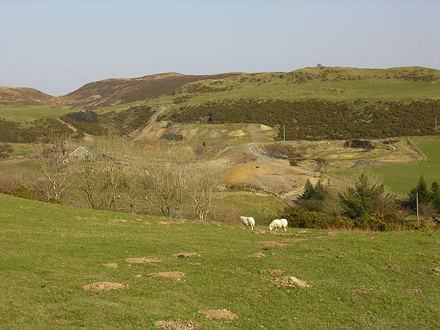
The Cwm Rheidol mining complex, in the hills above Ystumtuen east of Aberystwyth, was a group of four interconnected lead, zinc and silver mines — Ystumtuen, Penrhiw, Bwlchgwyn and Llwynteifi — worked intermittently from the late 17th century into the early 20th, whose acidic mine drainage remains an active water-quality problem in the Rheidol valley today.
History
The earliest definite record of mining at Ystumtuen dates from 1698; the mine was already active by 1705 and worked until 1727, before reopening in 1746 and being noted again in 1806, 1824 and 1839, under a succession of lessees. From 1844 attention shifted to a new adit mouth that became the Cwm Rheidol mine proper; by the late 19th century the four mines — Ystumtuen, Penrhiw, Bwlchgwyn and Llwynteifi — were all connected underground, with drainage carried out via the No. 6 and No. 9 adits into the River Rheidol. Ystumtuen itself appears to have closed around 1882, though later working centred on Cwm Rheidol continued to around 1917. A processing mill removed waste rock from the ore, which was then carried by aerial ropeway across the valley to the Vale of Rheidol Railway and on to Aberystwyth.
Geology
The mines exploit lead-zinc-silver veins typical of the Central Wales Orefield. Here they worked the Castell Lode within the mudstones and sandstones of the Llandovery Series of the Silurian, the mineralisation taking the form of quartz-cemented breccias carrying lead and zinc ores. The lode was followed from several separate setts on the mountain plateau above — Ystumtuen, Penrhiw, Bwlchgwyn and Llwynteifi — with the Cwm Rheidol workings in the valley below; by the late nineteenth century all four were connected underground.
Geological setting: Veins and Lodes (well documented example)
Workings
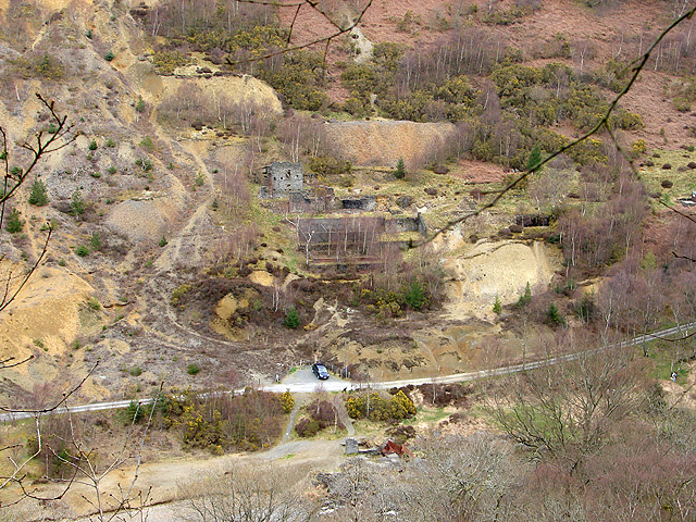
Drainage and access were by two adits driven into the steep valley slope above the River Rheidol: No. 6, driven in 1824, and No. 9, driven in 1874, the latter serving the Ystumtuen workings on the Castell Lode some 500 m distant. Once the four setts were connected underground the whole complex drained to the river through these two adits. At the valley floor a mill dressed the ore to remove waste rock, and an aerial ropeway then carried it across to the Vale of Rheidol Railway on the opposite side of the valley, and from there to Aberystwyth.
Closure
Working centred on Cwm Rheidol continued to around 1917, after Ystumtuen itself had closed around 1882.
What remains
The workings still drain from adits No. 6 and No. 9, and both discharges are strongly acidic — pH 3.9 and 3.0 respectively — carrying heavily elevated zinc, lead and cadmium. Between them they deliver roughly eight tonnes of metals into the River Rheidol each year, and the river fails Water Framework Directive standards for zinc and cadmium for 18 km downstream to its tidal limit. Ecological assessments have been equivocal: salmon in the Rheidol have shown surprising tolerance of zinc concentrations that average more than ten times the standard in places. Natural Resources Wales diverted a stream away from a shaft in 2007, drew down adit No. 9 in 2008 to reduce the risk of a catastrophic minewater blow-out, and in 2009 piped both discharges to a pilot vertical flow pond, running since September 2010, which has achieved removal rates up to 99 per cent though zinc removal averages nearer 60 per cent. Work has continued since: a roof collapse 15 m inside adit No. 9 prompted a detailed blow-out assessment that found 2,112 cubic metres of mine water trapped behind it. Reported in 2023, the response has included replacing deteriorated stream linings, gauging river flows, extending the blow-out lagoon and cutting a new blow-out channel from adit No. 9 to it, laid over two new pipes carrying mine water to the riverside filter beds; a permanent solution has been designed as an offline tunnel driven through spoil and bedrock to enter the adit 40 m behind the portal.
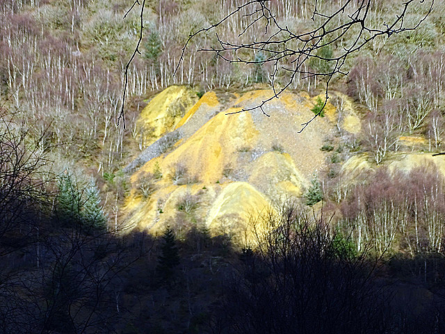
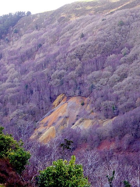
Spoil tips run down the steep valley side below the adits, and it is their erosion by the untreated discharges that the 2009 piping was meant to stop. The mill buildings survived in reasonable condition with corrugated iron roofs until the 1990s but are now ruinous. The pilot treatment plant, the blow-out lagoon and the piped adit discharges are themselves now the most prominent features of the site.
Related mines
- Penrhiw Mine — Penrhiw may have seen further use during Cwm Rheidol's neighbouring 1910-17 revival.
- Ystumtuen Mine — Activity shifted from Ystumtuen into an adit that developed into Cwm Rheidol mine from 1844, and Cwm Rheidol's 1910-17 revival may have reworked some of Ystumtuen's own ground.
Nearby mines
- Bwa-Drain Mine — 0.9 miles (1.4 km) NW
- Ystumtuen Mine — 1.0 miles (1.5 km) E
- Penrhiw Mine — 1.2 miles (1.9 km) E
- Bwlchgwyn Mine — 1.3 miles (2.1 km) E
- Llywernog Mine — 1.8 miles (2.9 km) NE
Straight-line distance, within 9 miles (15 km). Show on the map.
What's uncertain
Points where sources disagree or the record could not be settled; both accounts are kept. All open questions in the archive.
- The BGS mine-plans catalogue holds a BGS plan titled 'Rheidol Mine' (catalogue -, undated in the catalogue); the catalogue gives no location and the plan's details do not clearly tie it to this working, so it may belong to another of the same name. (uncertain) 5
Recorded claims
Individual factual claims, each attached to the source(s) that support it below. Where sources disagree, both are kept.
- The earliest definite record of mining at Ystumtuen dates from 1698; the site was worked until 1727, reopened in 1746, and recorded again in 1806, 1824 and 1839. 1
- By the late 19th century, Ystumtuen, Penrhiw, Bwlchgwyn and Llwynteifi were all connected underground, draining via the No. 6 and No. 9 adits into the River Rheidol. 2
- Drainage from the old Cwm Rheidol workings remains highly acidic, with elevated concentrations of zinc, lead and cadmium causing an 18km stretch of the River Rheidol downstream to fail Water Framework Directive standards for zinc and cadmium. 2
- Remediation work since 2007 has included diverting surface streams away from mine shafts, reducing drainage through the No. 9 adit to prevent a catastrophic release of stored mine water, and installing capture piping to control erosion and metal mobilisation. 2
- The Cwm Rheidol complex lies 15 km east of Aberystwyth and comprises the mines of Ystumtuen, Penrhiw, Bwlchgwyn and Llwynteifi, all connected underground by the late nineteenth century and draining to the River Rheidol through adits No. 6 and No. 9. 3,4
- Adit No. 6 was driven in 1824 and adit No. 9 in 1874, the latter to work the Castell Lode some 500 m distant. 4
- Adit No. 6 discharges at 8.3 L/s and pH 3.9 with 13 mg/L zinc; adit No. 9 at 0.6 L/s and pH 3.0 with 81 mg/L zinc and 101 mg/L iron. Together they carry roughly 8 tonnes of harmful metals into the River Rheidol each year. 3
- A roof collapse 15 m inside adit No. 9 triggered a blow-out assessment which found 2,112 cubic metres of trapped mine water. Intervention has included an extended blow-out lagoon and a new channel from the adit, with a permanent offline drainage tunnel designed to enter the adit 40 m behind the portal. 4
- The pilot vertical flow pond, running since September 2010 on a substrate of manure, woodchip and digested sewage sludge with shells, has achieved removal rates of up to 99 per cent for zinc, lead and cadmium, though zinc removal fluctuates and averages about 60 per cent. 3
- The BGS mine-plans catalogue holds a BGS plan titled 'Rheidol Mine' (catalogue -, undated in the catalogue); the catalogue gives no location and the plan's details do not clearly tie it to this working, so it may belong to another of the same name. (uncertain) 5
Photographs & further reading
A Coal Authority and Natural Resources Wales paper setting out what was found behind the adit No. 9 roof collapse — 2,112 cubic metres of impounded mine water — and the engineering designed to drain it safely and permanently.
View sourceSources
- (secondary) Ystumtuen — Wikipedia
- (primary) Cwm Rheidol Lead & Zinc Mine — case study — Natural Resources Wales
- (primary) Abandoned Mine Case Study: Cwm Rheidol Lead & Zinc Mine, June 2016 — Natural Resources Wales
- (primary) Preventative methods to avoid Blow-out at Cwm Rheidol Adit 9, Ystumtuen Mine Sett (IMWA 2023) — Terry, Leyland, Mason, Williams, Jones, Carline & Stanley — The Coal Authority / Natural Resources Wales, International Mine Water Association
- (primary) BGS / Mining Remediation Authority mine plans: RHEIDOL MINE — British Geological Survey / Mining Remediation Authority
Record created: 19 August 2026 · Last researched: 4 September 2026