 MineArchive
Gellireirin Mine
| Also known as | Gelli Mine, Gellirheiron Mine, Gelli'reirin Mine |
|---|---|
| Location | Rheidol valley, about 3 miles below Devil's Bridge, Ceredigion — 52.3978, -3.9056 (approximate) |
| Commodity | Lead |
| Type | Metal |
| Worked | About 1800–1864 |
| Maximum depth | At least 20 fathoms below Bonsall's level |
Gellireirin, or Gelli, was a lead mine beside the road and the River Rheidol, about three miles below Devil's Bridge in Ceredigion. Its workings and tips made the pale scar on the valley side known as the Stag. The best of the ore, said to have been an almost solid vein six feet wide, was taken about 1800. A deep adit was begun about 1835, the mine was worked again from 1856 to 1864, and it has returned 706 tons of lead ore since 1845.
Location
Approximate location. The large pin is this mine; the small round markers are the nearest mines on record. Click one for its page. View on full map
History
The ore was found on the hillside near the head of the Stag, the stag-shaped scar that the mine left on the north side of the valley. It is said to have formed an almost solid vein of galena six feet wide. Bonsall's level, driven northward under what are now the forefeet of the Stag, cut the lode, and the ore was worked from there up to the surface and for at least 20 fathoms below, along a length of about 60 fathoms. That was about 1800, and the mine's chief returns belong to those years.
About 1835 a deep adit was started towards the lode from near the roadside, west of the old workings. It seems to have taken many years to finish. More work was done between 1856 and 1864, when 200 to 300 tons of ore are said to have been picked back out of the old waste heaps. The recorded returns, which begin in 1845, come to 706 tons of lead ore, with a best year of 209 tons in 1859.
Geology
The lode, where first found, is said to have been an almost solid vein of galena six feet wide; the ore body was about 60 fathoms long.
Geological setting: Veins and Lodes (historical documentary reference)
Workings
Bonsall's level, at about 530 feet above sea level, was driven north to the lode, which was worked from it to the surface and for at least 20 fathoms beneath. The deep adit, at about 210 feet, runs towards the lode from near the roadside west of the old workings.
Closure
The last recorded working was between 1856 and 1864.
What remains
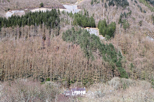
The Stag is still plain to see across the valley: in 2021 its pale tips showed through the forestry on the hillside above a white house by the road.
The waste tips that make up the Stag.
Nearby mines
- Bwa-Drain Mine — 0.5 miles (0.7 km) E
- Tyllwyd Mine — 0.4 miles (0.7 km) W
- Cwmbrwyno Mine — 0.9 miles (1.4 km) NE
- Caegynon Mine — 1.1 miles (1.7 km) SE
- Cwm Rheidol Mine — 1.1 miles (1.7 km) SE
Straight-line distance, within 9 miles (15 km). Show on the map.
Further reading
The catalogue entry for the mine's location notes of 1857, held by the British Geological Survey.
View sourceSources
- (primary) Lead and Zinc: The Mining District of North Cardiganshire and West Montgomeryshire (Special Reports on the Mineral Resources of Great Britain, vol. XX), O. T. Jones, 1922 — Memoirs of the Geological Survey
- (observational) The 'Stag' viewed from Coed Pant-mawr (Geograph photograph 7052874, 2021) — Geograph
- (primary) Mine plan: Gellireiron Mine or Gelli Mine, location and notes, 1857 (KP16969) — British Geological Survey
Record created: 18 November 2026 · Last researched: 18 November 2026