 MineArchive
Caegynon Mine
| Also known as | Cae Gynon Mine, Caegynon Lead Mine |
|---|---|
| Location | North side of Cwm Rheidol, Melindwr, Ceredigion — 52.3886, -3.8852 (exact) |
| Commodities | Lead, Zinc |
| Type | Metal |
| Worked | 1850–1939 |
| Maximum depth | 70 fathoms below the deep adit (about 128 m) |
Caegynon was a lead and zinc mine on the north side of the Rheidol valley, beside the road three-quarters of a mile below the Cwm Rheidol mine. Its engine shaft was sunk between 1850 and 1853 and it worked in three short spells to 1875, returning 371 tons of lead ore. It was taken up again in the early twentieth century, and its last plan was deposited as abandoned in 1939.
Location
Recorded location. The large pin is this mine; the small round markers are the nearest mines on record. Click one for its page. View on full map
History
The engine shaft was sunk between 1850 and 1853. A 25-foot waterwheel pumped the mine and drove a crushing mill, and a second wheel of 20 feet worked a drawing machine. Work went on from 1850 to 1856, in 1858 and 1859, and again from 1871 to 1875, and lead ore was returned in ten of those years: 371 tons in all, giving 277 tons of lead.
Two lodes were worked, 15 to 20 fathoms apart. The northern one carried galena and the southern mainly blende, and it was the lead that was followed; the blende lode was never worked to any great extent. The shaft went down between the two on the underlie and reached 70 fathoms below the deep adit.
The site was worked over again in the early twentieth century, which left corrugated-iron buildings on concrete bases among the older remains. A plan of the mine was deposited as abandoned in 1939.
Geology
Both lodes dip south at 60 to 65 degrees. Where one is exposed near the shallow adit it is a shattered belt several yards wide, its many fractures carrying blende, or blende with galena, and some iron pyrites; the waste heaps hold blende with marcasite. It closely resembles the Castell lode at Ystumtuen. The strike here is somewhat north of west, which suggests the mine sits on one of the swerves that carry that lode north of its usual course. On the north lode the ore lay mainly west of the shaft, in a nearly vertical shoot.
Geological setting: Veins and Lodes (well documented example)
Workings
An inclined shaft was sunk between the two lodes, which were reached from it by cross-cuts north and south. Two adits drained the ground: a shallow one driven east from the top of the shaft, and a deep adit from the roadside that drains the workings to about 10 fathoms. The shaft goes 70 fathoms below the deep adit. Plans of 1875 and 1899 survive, though their compass bearings cannot be trusted.
Closure
The nineteenth-century mine last returned ore in 1875. The early twentieth-century reworking ended with a plan deposited as abandoned in 1939.
What remains
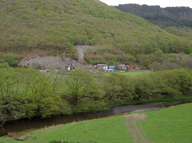
The bare grey tips still stand out on the valley side, where the lead has kept the vegetation off them, and the houses on the site are lived in. A cottage there may be the old mine office.
An open shaft, the entrances to levels, the spoil tips and some early twentieth-century buildings of corrugated iron on concrete bases.
Nearby mines
- Cwm Rheidol Mine — 0.0 miles (0.0 km) SW
- Bwa-Drain Mine — 0.9 miles (1.4 km) NW
- Ystumtuen Mine — 1.0 miles (1.5 km) E
- Gellireirin Mine — 1.1 miles (1.7 km) NW
- Penrhiw Mine — 1.2 miles (1.9 km) E
Straight-line distance, within 9 miles (15 km). Show on the map.
Further reading
The Royal Commission's site record, with aerial photographs of 1992 and views of the mine buildings.
View sourceSources
- (primary) Caegynon Mine, Cwm Rheidol (NPRN 91749) — Coflein, Royal Commission on the Ancient and Historical Monuments of Wales
- (primary) Lead and Zinc: The Mining District of North Cardiganshire and West Montgomeryshire (Special Reports on the Mineral Resources of Great Britain, vol. XX), O. T. Jones, 1922 — Memoirs of the Geological Survey
- (primary) Mine plan: Caegynon Lead Mine, abandoned 1939 (MP23329) — British Geological Survey
- (observational) Caegynon mine, Cwm Rheidol (Geograph photograph 4607568, 2015) — Geograph
Record created: 18 November 2026 · Last researched: 18 November 2026