 MineArchive
Underlie
| Category | Prospecting & Exploration |
|---|
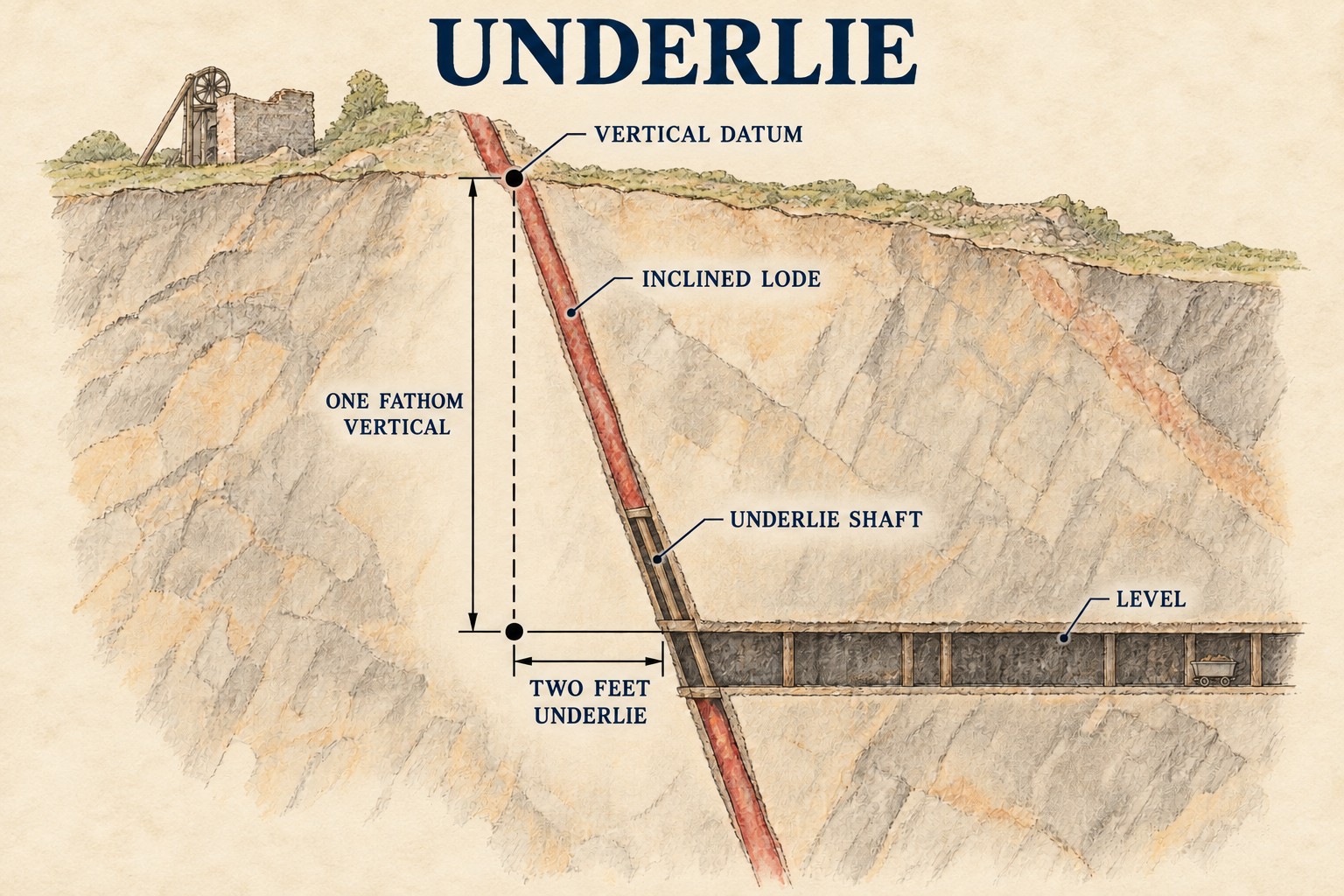
The old British convention for describing how far a vein or lode departs from vertical, expressed not as an angle in degrees but as a horizontal distance -- inches or feet -- per fathom of vertical depth.
Historical usage
The convention is recorded across 19th-century mine surveys nationwide, from Cornwall to the Yorkshire Dales: an 1856 survey recorded Dolcoath's main lode as running close to east-west and dipping 2 feet south in the fathom, and Condurow's as dipping 18 inches in the fathom; contemporary reports on the Grassington and Craven Moor lead mines in Yorkshire likewise describe veins whose 'underlie' changed unpredictably with depth.
How it worked
A vein's underlie was established by survey and reported alongside its strike (the compass bearing of the vein at surface), together telling a mine captain exactly how far a shaft or level would need to deviate from a straight vertical or horizontal line to stay within the ore as workings went deeper.
Why it was used
A vertical shaft sunk straight down, or a level driven straight in, would drift away from an inclined vein as depth increased; knowing the underlie let engineers plan a shaft's angle, or an 'underlie shaft' following the vein's own incline, so that workings continued to intersect the ore rather than losing it.
Risks & limitations
A vein's underlie could change abruptly and unpredictably with depth -- as recorded at several Yorkshire Dales mines, where an increased or reversed underlie could throw out workings planned on an earlier survey, sometimes requiring a new shaft to be sunk to recover the lost ground.
Regional variation
The same measurement is expressed today as dip, conventionally given in degrees from horizontal rather than as a distance per fathom -- the Strike and Dip geology record covers the modern convention and the underlying geometry it describes.
Related terminology
Mines associated with this term
5 examples chosen from 8 linked records — the term page is not an index.
- Wheal Mary Ann — Cornwall (well documented example)
The mine's own recorded workings give a precise underlie for the worked lode -- an average of about 15 inches east per fathom. - Cherry Hinton Pit — Cambridgeshire (well documented example)
Named in this record’s geology: “The pits cut the Cretaceous Chalk that underlies much of south-east England, here on the edge of the Gog Magog Hills.…” - Emmer Green (Hanover) Chalk Mine — Berkshire (well documented example)
Named in this record’s history: “…distinct sets of accessible workings. The two northern mines partly underlie land managed by the Scout Association and are connected underground;…” - Glenchass Mine — Isle of Man (well documented example)
Named in this record’s geology: “A lode running N 18-20 degrees W with an easterly underlie, intersected by the cliff in the recess known as Cotlooway, carrying…” - Kinneil Colliery — Falkirk (well documented example)
Named in this record’s geology: “…and Lochgelly Splint among them — in the Carboniferous sequence that underlies the Forth valley and continues uninterrupted beneath the firth…”
Sources
- (primary) Memoirs 1965: Extracts from Old Editions of the Mining Journal — Northern Cavern & Mine Research Society
- (secondary) A Cornish mining glossary — Cornish Mining World Heritage Site (UNESCO)
Record created: 2 September 2026 · Last researched: 2 September 2026