 MineArchive
Cambois Colliery
| Location | Cambois, north of Blyth, Northumberland — 55.1539, -1.5261 (approximate) |
|---|---|
| Commodity | Coal |
| Type | Coal |
| Worked | About 1862–20 April 1968 |
| Maximum depth | Unknown. |
| Operators | Cowpen & North Seaton Coal Co. (1862–1889), Cowpen Coal Co. Ltd (1890–1946), National Coal Board (1947–1968) |
Overview
The colliery that made Cambois, on the north bank of the Blyth, working steam coal for the Cowpen companies from about 1862 and later for the National Coal Board. Its coal went by a Coal Board line two miles down to staithes on the river. The village kept a Miners' Welfare Institute, rebuilt in 1929 after a fire and reopened in 2023 as an arts centre, and the colliery closed in the week ending 20 April 1968. A pit wheel monument and some pithead buildings still stand.
History
Cambois was a township of Bedlingtonshire, part of County Durham until 1844, and a coal mining village from 1862 until the colliery closed in the week ending 20 April 1968. The Durham Mining Museum's returns show the Cowpen and North Seaton Coal Company as owners in the 1860s and the Cowpen Coal Company Limited from the 1890s, with coal and fireclay in the early returns and steam coal from 1894; the National Coal Board took the colliery over in 1947 and closed it on 20 April 1968. The museum names 111 men and boys killed at the colliery and records no disaster of five or more. The pit stood on the north bank of the Blyth, and a National Coal Board railway about two miles long carried its coal to staithes on the east bank of the river. The village's social centre was the Miners' Welfare Institute in Ridley Terrace; the present building, the fourth, dates from 1929 and was built after an earlier institute burned down. Unused for more than a decade, it reopened in 2023 as an arts centre and community hub called The Tute.
Geology
Steam coal of the Northumberland coalfield on the coast north of Blyth, with fireclay raised in the earlier returns; the Low Main seam was abandoned in 1926.
Geological setting: Sedimentary Beds and Seams (historical documentary reference)
Workings
Shaft workings on the north bank of the Blyth, served by a colliery railway about two miles long running to staithes on the east bank of the river.
Closure
The colliery closed in the week ending 20 April 1968 under the National Coal Board, ending a century of mining at Cambois.
What remains
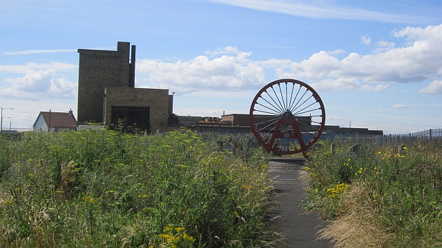
A pit wheel monument stands on the site among rough grass, and some of the pithead buildings survive in use as industrial premises.
A mining monument with a red-painted pit wheel, and surviving pithead buildings now used as industrial premises.
Redevelopment
Industrial premises in the former pithead buildings.
Nearby mines
- Bates Colliery — 3.0 km S
- Bomarsund Colliery — 3.2 km SW
- Choppington 'B' Pit — 3.3 km W
- Bebside Colliery — 3.5 km SW
- Choppington 'A' Pit — 3.5 km W
Straight-line distance, within 15 km. Show on the map.
Recorded claims
Individual factual claims, each attached to the source(s) that support it below. Where sources disagree, both are kept.
- Cambois was a coal mining village from 1862 until the colliery closed in the week ending 20 April 1968. 1,2
- The Cowpen and North Seaton Coal Company owned the colliery in the 1860s and the Cowpen Coal Company Limited from the 1890s, with the National Coal Board taking over in 1947. 1
- The returns record coal and fireclay in the early years and steam coal from 1894; the Low Main seam was abandoned in 1926. 1
- A National Coal Board railway about two miles long linked the colliery to staithes on the east bank of the Blyth. 2
- The village's social centre was the Miners' Welfare Institute in Ridley Terrace, the present building being the fourth, of 1929, put up after an earlier institute was destroyed by fire; it reopened in 2023 as an arts centre called The Tute. 2
- The Durham Mining Museum names 111 men and boys killed at Cambois Colliery and records no disaster of five or more. 1
Photographs & further reading
Owners, output and employment by year, seam abandonments and the names of 111 men killed at the colliery.
View sourceSources
- (secondary) Cambois Colliery — Durham Mining Museum
- (secondary) Cambois — Wikipedia
Record created: 20 September 2026 · Last researched: 20 September 2026