 MineArchive
West Sleekburn Colliery
| Also known as | Sleekburn Colliery, The Winning, Bedlington 'E' |
|---|---|
| Location | West Sleekburn, between Stakeford and Cambois, near Bedlington, Northumberland — 55.1563, -1.5613 (approximate) |
| Commodity | Coal |
| Type | Coal |
| Worked | 1859–1962 |
| Maximum depth | 706 feet (shaft section) |
| Operators | Bedlington Coal Co. Ltd |
Overview
The Bedlington Coal Company's colliery between Stakeford and Cambois, sunk from 1859 and known as the Winning or Bedlington 'E'. A modest pit with a large workforce, nearly a thousand in the 1920s, it closed in 1962.
History
West Sleekburn Colliery, known as the Winning and as Bedlington 'E', was begun in 1859 between Stakeford and Cambois, near Bedlington, and belonged to the Bedlington Coal Company from the 1860s. It was connected to the Blyth and Tyne Railway by two spurs, north and south, towards North Blyth, and three sets of colliery rows were built around the pit for the miners and their families. A gazetteer of 1894-95 called it an extensive colliery, with the people of both Sleekburns chiefly miners, Wesleyan and Primitive Methodist chapels, and a post office named Sleekburn Colliery. The shaft was sunk to about 706 feet.
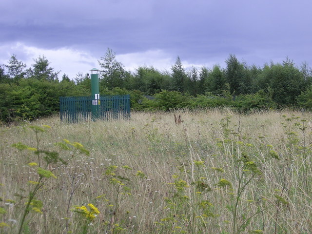
The workforce, 625 in 1894, rose to 782 in 1910 and to between 900 and 984 from 1924 to 1945: just under a thousand in the 1920s, a large number for so modest a working. It worked the Bensham, Low Main and Yard, and from 1921 the Plessey, with the Main by 1935. Plans for the Five Quarter and Main were deposited as abandoned in November 1952 and for the Yard in March 1959 and March 1962, when the colliery closed. A ventilation pipe over a capped shaft is all that remains.
Geology
Northumberland Coal Measures: the Bensham, Low Main, Yard, Plessey, Main and Five Quarter.
Workings
One winding pit, the Winning, with spurs north and south to the Blyth and Tyne Railway.
Closure
Closed in 1962; the last Yard seam plans were abandoned on 16 March 1962.
What remains
The site is open grassland and scrub; a vent pipe marks the old shaft.
A ventilation pipe over the capped shaft.
Redevelopment
Unknown.
Related mines
- Bedlington 'D' Colliery — Lettered pits of the Bedlington Coal Company: West Sleekburn was Bedlington 'E'.
- Bomarsund Colliery — Both Bedlington Coal Company collieries in the Bedlington group.
Nearby mines
- Choppington 'A' Pit — 1.0 miles (1.6 km) SW
- Choppington 'B' Pit — 1.0 miles (1.6 km) SW
- Bomarsund Colliery — 1.1 miles (1.7 km) SW
- Cambois Colliery — 1.4 miles (2.3 km) E
- Bebside Colliery — 2.0 miles (3.3 km) S
Straight-line distance, within 9 miles (15 km). Show on the map.
Recorded claims
Individual factual claims, each attached to the source(s) that support it below. Where sources disagree, both are kept.
- West Sleekburn Colliery was begun in 1859. 1
- The colliery was connected to the Blyth and Tyne Railway by two spurs, with three sets of colliery rows around the pit. 2
- Just under a thousand worked at the colliery in the 1920s; 984 were employed in 1927. 1,2
- In 1894-95 West Sleekburn had an extensive colliery, and the inhabitants were chiefly miners. 3
- The colliery closed in 1962; its last Yard seam plans were abandoned on 16 March 1962. 1,4
Photographs & further reading
Owners, employment, seams and those killed at the colliery.
View sourceThe pit, its railway spurs and colliery rows.
View sourceSources
- (primary) West Sleekburn Colliery — Durham Mining Museum
- (secondary) West Sleekburn Colliery (Coals Archive) — North East Heritage Library
- (secondary) East and West Sleekburn, Northumberland — UK Genealogy Archives (from the Comprehensive Gazetteer of England & Wales, 1894-5)
- (primary) BGS mine plan: Bedlington 'E' or West Sleekburn or The Winning, Yard, abandoned 1962 — BGS / Mining Remediation Authority mine plans
Record created: 4 October 2026 · Last researched: 4 October 2026