 MineArchive
Choppington 'A' Pit
| Location | Choppington, Northumberland — 55.1460, -1.5800 (approximate) |
|---|---|
| Commodity | Coal |
| Type | Coal |
| Worked | 1857–1966 |
| Maximum depth | Shaft sunk to 63 fathoms. |
| Operators | Lambert, Nicholson & Co. (1860–1880), Bebside Coal Co. (1880–1885), Bebside & Choppington Coal Co. (1885–1930), Choppington Collieries Ltd. (1930–1947), National Coal Board (1947–1966) |
Overview
A Northumberland colliery opened in 1857 alongside the Blyth & Tyne railway, passing through five owners over more than a century before closing in 1966; its former spoil heap is now Choppington Community Woodland.
History
Choppington 'A' Pit was opened in 1857, linked to the Morpeth branch of the Blyth & Tyne railway for shipping coal down to the Tyne, with a shaft sunk to 63 fathoms. Over more than a century of working the colliery passed through five distinct owners: Lambert, Nicholson & Co. in the 1860s, the Bebside Coal Co. in the 1880s, the Bebside & Choppington Coal Co. also in the 1880s, Choppington Collieries Ltd. from the 1930s, and the National Coal Board following nationalisation in 1947. By the 1890s the surrounding settlement had grown large enough to house close to 500 workers across both the 'A' and 'B' pits. The colliery finally closed on 16 July 1966. The former spoil heap has since been removed and landscaped, and the site of the shaft now lies within Choppington Community Woodland, renamed Choppington Woods. The Bensham seam was given up across the A, B, C and D pits in September 1959, seven years before the A pit closed.
Geology
Coal of the Northumberland field; the seams worked are not recorded.
Workings
A single shaft sunk to 63 fathoms in 1857, linked to the Blyth & Tyne railway's Morpeth branch for shipping coal to the Tyne.
Closure
Closed on 16 July 1966; the former spoil heap has since been removed and the site landscaped.
What remains
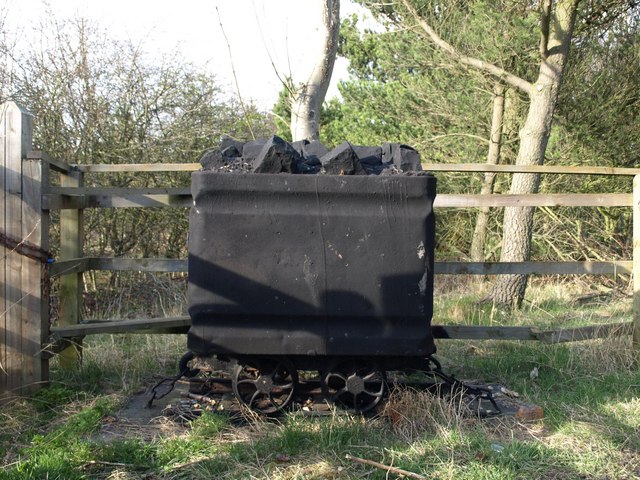
The site of the shaft now lies within Choppington Community Woodland (renamed Choppington Woods after the spoil heap's removal); a memorial coal tub marks the former pit.
A memorial coal tub, within what is now Choppington Community Woodland.
Related mines
- Bebside Colliery — Both collieries were worked by the same companies — the Bebside & Choppington Coal Co. in the 1880s and the Bebside Coal Co. from the 1890s — which took their name from the two places.
- Choppington 'B' Pit — Companion shafts sharing the same five owners and linked by wagonway.
Nearby mines
- Choppington 'B' Pit — 0.2 miles (0.3 km) SE
- Bomarsund Colliery — 0.4 miles (0.7 km) SE
- Bedlington 'A' Colliery — 0.5 miles (0.8 km) SE
- West Sleekburn Colliery — 1.0 miles (1.6 km) NE
- Bedlington 'D' Colliery — 1.1 miles (1.7 km) SW
Straight-line distance, within 9 miles (15 km). Show on the map.
Culture
- Thomas Burt (Labour)
Burt was elected in 1864 to represent Choppington's own miners as their delegate on the Northumberland and Durham Miners' Association -- linked to 'A' Pit as the only pit operating in Choppington during his 1860-65 residence there, though no source names the specific pit he himself worked at.
Recorded claims
Individual factual claims, each attached to the source(s) that support it below. Where sources disagree, both are kept.
- Choppington 'A' Pit opened in 1857 with a shaft sunk to 63 fathoms, linked to the Blyth & Tyne railway's Morpeth branch; it passed through five owners -- Lambert Nicholson & Co., Bebside Coal Co., Bebside & Choppington Coal Co., Choppington Collieries Ltd. and the National Coal Board -- before closing on 16 July 1966. 1
- By the 1890s the settlement around the 'A' and 'B' pits housed close to 500 workers; the site of the shaft now lies within Choppington Community Woodland after the spoil heap's removal. 2
- The Mining Remediation Authority holds abandonment plan NC345 for the Bensham seam of Choppington's A, B, C and D pits, abandoned on 26 September 1959. 3
Photographs & further reading
A fuller history of the colliery and its ownership chain.
View sourceSources
- (secondary) Choppington Colliery A Pit — North East Heritage Library
- (secondary) Choppington Colliery (1857-1966) — Co-Curate (Newcastle University)
- (primary) CHOPPINGTON "A" "B" "C" "D" (Mine Remediation Authority abandonment plan NC345, BGS mine plans catalogue) — British Geological Survey / Mining Remediation Authority
Record created: 31 August 2026 · Last researched: 24 September 2026