 MineArchive
North Seaton Colliery
| Location | North Seaton, between Ashington and Newbiggin-by-the-Sea, Northumberland — 55.1652, -1.5430 (approximate) |
|---|---|
| Commodity | Coal |
| Type | Coal |
| Worked | 1859–20 January 1961 |
| Maximum depth | About 742 feet (1859 sinking, below the Low Main) |
| Operators | Cowpen & North Seaton Coal Co. (1859–1889), Cowpen Coal Co. Ltd (1890–1946), National Coal Board (1947–1961) |
Overview
A steam-coal colliery at North Seaton, near Ashington, sunk in 1859 by the Cowpen and North Seaton Coal Company, which employed over a thousand in the 1910s-20s and closed under the National Coal Board in January 1961.
History
North Seaton Colliery lay at North Seaton, between Ashington and Newbiggin-by-the-Sea. Its shaft was sunk in 1859 from a surface about 70 feet above sea level, passing the Yard seam at 423 feet and reaching the six-foot Low Main at 730 feet. The Cowpen and North Seaton Coal Company owned it in the 1860s. The 1866 Ordnance Survey map shows an engine house, a reservoir and a powder house, with two terraced rows, later Fourth Single Row and Saw Mill Road, running towards the colliery village; by 1898 the village had spread west and the colliery was linked to the Newbiggin branch railway by a mineral line.
From the 1890s the Cowpen Coal Company Ltd owned it, working steam coal from the Low Main, Main, Yard and Low Low Main seams. It employed 890 in 1894 and 1,180 in 1921, its largest workforce, under managers who included Thomas Moore in the 1880s, R. B. Dormand in the 1900s and Isaac Brown in the 1920s. The Low Main was abandoned in 1926. Over 110 deaths are recorded at the colliery between 1859 and 1959; on 26 November 1905 an explosion killed a stoneman and a timberer.
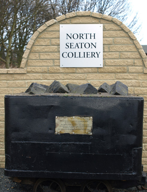
The National Coal Board took it over in 1947, when it employed 876 and raised 314,000 tons; there were 952 men in 1950, working the Main and later the Top and Bottom Main and Five Quarter. The colliery closed on 20 January 1961, and its Top Main plans were closed in April. Demolition of the colliery and its terraces was under way in 1971, the land was reclaimed in 1978, and a coal tub was set up in 1987 to commemorate the colliery; the site has since been built over.
Geology
The 1859 sinking passed the Yard seam (3 feet 5 inches at 423 feet) and reached the Low Main (6 feet at 730 feet), with coals below; the Main, Low Low Main, Top and Bottom Main and Five Quarter were also worked.
Workings
A shaft of 1859 with an engine house, reservoir and powder house; linked to the Newbiggin branch railway by a mineral line by 1898.
Closure
Closed on 20 January 1961; the Top Main workings were abandoned in April 1961.
What remains
The site was cleared by the mid-1970s, reclaimed in 1978 and has since been developed; a commemorative coal tub was placed there in 1987.
Some below-ground remains may survive; a commemorative coal tub was placed in 1987.
Redevelopment
The land was reclaimed in 1978 and has since been built over.
Nearby mines
- West Sleekburn Colliery — 0.9 miles (1.5 km) SW
- Cambois Colliery — 1.0 miles (1.7 km) SE
- Woodhorn Colliery — 1.7 miles (2.7 km) N
- Choppington 'B' Pit — 1.9 miles (3.1 km) SW
- Bomarsund Colliery — 2.0 miles (3.2 km) SW
Straight-line distance, within 9 miles (15 km). Show on the map.
Recorded claims
Individual factual claims, each attached to the source(s) that support it below. Where sources disagree, both are kept.
- Sunk in 1859, reaching the Low Main seam, six feet thick, at 730 feet. 1,2
- The 1866 Ordnance Survey map shows an engine house, a reservoir and a powder house. 3
- Employed 1,180 people in 1921. 1
- Employed 876 people and raised 314,000 tons in 1947. 1
- Thomas Moore was manager from 1882 to 1890. 4
- Closed on 20 January 1961. 5,1
- The Top Main workings were abandoned in April 1961. 6
- Demolition was under way in 1971, and the site has since been developed. 3
- The land was reclaimed in 1978 and a commemorative coal tub placed in 1987. 7
Photographs & further reading
The Northumberland historic environment record for the colliery and its village.
View sourceSources
- (primary) North Seaton Colliery — Durham Mining Museum
- (primary) Account of Strata sunk through at North Seaton Colliery, 1859 (An Account of the strata of Northumberland & Durham as proved by Borings & Sinkings, Vol. L-R, 1887, no. 1475) — North of England Institute of Mining & Mechanical Engineers, via the Durham Mining Museum
- (secondary) North Seaton Colliery (Ashington) (HER N18091) — Keys to the Past (Durham and Northumberland HER)
- (primary) North Seaton Colliery: Colliery Management (prior to 1970) — Durham Mining Museum
- (secondary) NCB Collieries - England (Northern Mine Research Society) — Northern Mine Research Society
- (primary) North Seaton Mine Plans (Mining Remediation Authority plan NC409, Top Main, abandoned April 1961) — British Geological Survey / Mining Remediation Authority
- (observational) Coal Tub At North Seaton (Geograph 742395, Kevin Richardson, 2008) — Geograph Britain and Ireland
Record created: 9 October 2026 · Last researched: 9 October 2026